


Convert big data into fleet management information
Last updated on March 8, 2023 in Productivity by Edward Kulperger | 3 minute read
Table of contents
- Geotab is collecting large amounts of data, at approximately:
- Where does all this data go and how is it used?
- How do I know what data is relevant to my needs?
- Should a delivery vehicle and driver on a country road be measured using the same variables as a vehicle driving in a big city?
- Is relevant information standardized across all businesses?
Collecting data is the just the beginning. Read about some important considerations for using their fleet management information in a Big Data project.
[Update: As of June 2016, Geotab nows collects 900 million points of data daily.]
Many firms are looking to define what is the true meaning of Big Data in the telematics industry. In today’s data-driven economy, companies are wirelessly collecting huge volumes of data. However, collecting data is the just the beginning and the easy part – the key differentiator is ensuring that useful and relevant data is available.
Geotab is collecting large amounts of data, at approximately:
- 120 million data points per day
- 3.5 billion data points per month
- 44 billion records per year
And to top this even further...these numbers are continuously evolving as Geotab adds approximately 10,000 new vehicle subscriptions per month!
A key question for any business or manager is – will the data collected today be used in the same manner 1-10 years down the road? The answer is probably not. Therefore, it is absolutely critical to maintain this data in a structure that will guarantee its usage and continual benefit even down the road.
Where does all this data go and how is it used?
Geotab stores the data for one year and then securely archives it. This is a large consideration that not many telematics companies have invested in, yet it is critical for GPS fleet management. Despite the fact that what is relevant today may not be relevant tomorrow, one must consider the fact that specific relevant information may need to be used in a few months or even years down the road. While customers can choose to hold onto their data, the option for customers to purge the data also exists.
How do I know what data is relevant to my needs?
The term “relevant information” is often defined as “data which is applicable to the situation or issue at hand that can help solve a problem or contribute to a solution” (Canadian Business Dictionary). An inherent issue for fleet owners and operators is to understand and ensure that the vehicles are being operated in a safe and efficient manner. In this particular situation, accelerometer data could be deemed relevant information as it can be utilized in an effort to achieve this safety and efficiency solution.
However, accelerometer data is only a small part of this solution. Additional variables that may be included to determine safe and efficient driver and vehicle performance are:
- RPM
- Idling
- Fuel usage
- Actual speed vs posted speed
- Tailgating
- Lane departures
- & other engine data sets
Should a delivery vehicle and driver on a country road be measured using the same variables as a vehicle driving in a big city?
One can anticipate much more harsh braking behavior on a vehicle driving in the city as that environment potentially dictates that behavior in order to keep safe. Fleets should have the ability to configure their solution according to their criteria and environment.
The data must not only be available to solve the problem, but it must be configurable in order to determine the correct solution. A vehicle or fleet owner must be able to ‘fine-tune’ the data in its reports to provide relevant information. This means that not only can one fine-tune reports, but one should be able to look retroactively at historical data. For example, if a fleet were to implement a new idling rule between the hours of 8 and 10 AM, through the use of Geotab solutions the company can implement the new rule as well as study the historical idling activity in those hours. This additional analysis will provide a baseline to measure the new rule against. One can then post process the data to be relevant information.
Is relevant information standardized across all businesses?
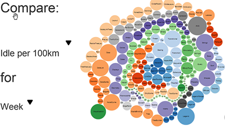
What is relevant to one business may be irrelevant to another. Even within a business, information is used in different means. For example, a fleet owner may want to see how his fleet is performing from a macro level while a regional operator may want to see how his subset of vehicles are performing. Therefore the information must be configurable to not only the business, but to regions or groups of people with the same goals and objectives.
One way to facilitate manageable views of the same data is a configurable graphical representation, as seen below. The different colors represent different regions and each bubble symbolizes a driver – safe and efficient drivers may be identified and rewarded while outliers may be proactively coached within their region or globally.
What's the telematics big data end game? The ultimate goal of telematics Big Data is to ensure safe and efficient roads and vehicles. This means zero fatalities while eliminating traffic congestion and limiting carbon output. These efforts can all be accomplished through the application of Big Data in Geotab solutions.
Geotab servers are structured in a unique way – one that ensures the data collected from vehicles is secure, available, and entirely configurable. Vehicle operators need this assurance, as do the owners of multiple vehicles and fleets. It is important to note that not all telematics companies are architected to ensure their data can be applied for further usage and customization.
Click here to read more about how to get started with big data.
If you liked this post, let us know!

Disclaimer
Geotab's blog posts are intended to provide information and encourage discussion on topics of interest to the telematics community at large. Geotab is not providing technical, professional or legal advice through these blog posts. While every effort has been made to ensure the information in this blog post is timely and accurate, errors and omissions may occur, and the information presented here may become out-of-date with the passage of time.
Get industry tips and insights
Sign up for monthly news and tips from our award-winning fleet management blog. You can unsubscribe at any time.
Republish this article for free
Other posts you might like

ELD self-certification: What you need to know
April 10, 2024

Geotab 2024 discussion recap: A Data-Driven Journey in Fleet Maintenance
March 11, 2024

Routes to riches – Geotab Routing and Optimization drives operational efficiency and cost management
February 15, 2024

What is ADAS?
January 12, 2024