What is GPS?
From GPS navigation to fleet GPS tracking, this technology shapes how Southeast Asia moves. See how a GPS tracking system can cut costs and improve safety for your fleet.

By Geotab Team
Aug 13, 2026
Key Insights
- GPS stands for Global Positioning System — a network of satellites that provides real-time location, speed and time data to GPS devices anywhere on Earth.
- GPS works through trilateration, using signals from at least four satellites to calculate an exact position in three dimensions.
- There are five main uses of GPS: location, navigation, tracking, mapping and timing.
- GPS tracking uses GPS technology to monitor the real-time movement of vehicles, assets or people — and is widely used in fleet management across Southeast Asia.
- A GPS tracking system combines a GPS device, cellular connectivity and fleet management software to give managers live visibility into every vehicle in their fleet.
- GPS navigation systems help drivers find routes; GPS tracking systems help fleet managers monitor how vehicles are being used, even when they are not in the vehicle.
- GNSS devices — which access multiple satellite networks including GPS and GLONASS — are more accurate than basic GPS-only devices, particularly in urban areas.
- GPS technology continues to improve: next-generation satellites will deliver accuracy to within 1–3 metres and greater resistance to signal interference.
GPS, or the Global Positioning System, is a satellite navigation system that provides real-time location, velocity and time data. Today, GPS is the backbone of GPS tracking systems used across transportation, logistics and fleet management — from smartphone navigation apps to vehicle tracking devices installed in commercial fleets across Malaysia, Philippines and Southeast Asia. Read on to learn how GPS works, how accurate it is, and how GPS tracking helps fleet businesses operate more efficiently.
See also: Telematics glossary: 100+ terms to know
What is GPS and how does it work?
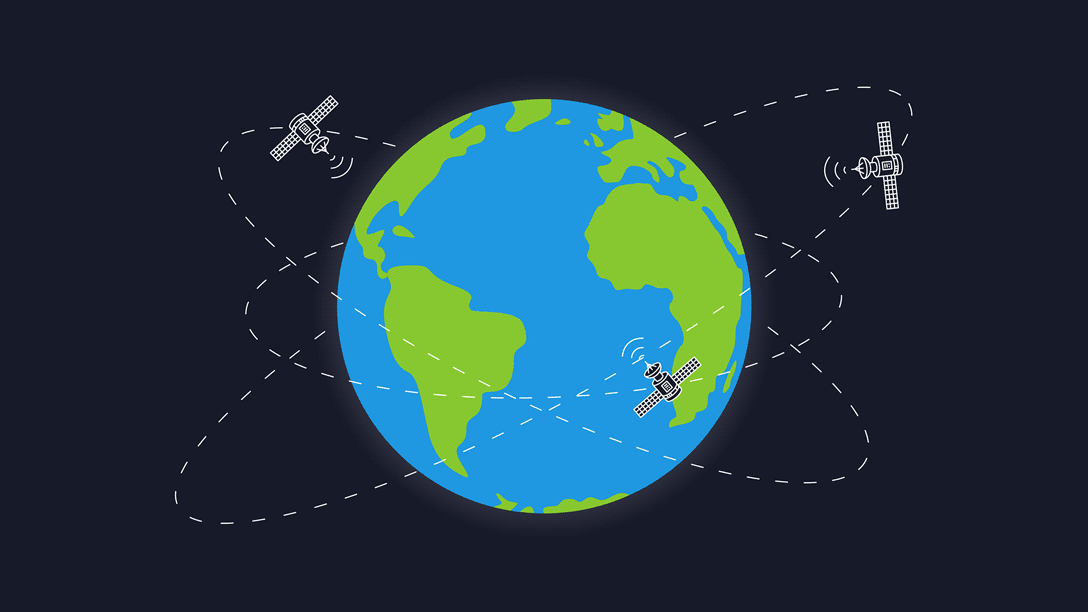
The Global Positioning System (GPS) is a navigation system using satellites, a receiver and algorithms to synchronise location, velocity and time data for air, sea and land travel.
The satellite system consists of a constellation of 24 satellites in six Earth-centered orbital planes, each with four satellites, orbiting at 13,000 miles (20,000 km) above Earth and traveling at a speed of 8,700 mph (14,000 km/h).
While we only need three satellites to produce a location on earth’s surface, a fourth satellite is often used to validate the information from the other three. The fourth satellite also moves us into the third-dimension and allows us to calculate the altitude of a device.
What are the three elements of GPS?
GPS is made up of three different components, called segments, that work together to provide location information.
The three segments of GPS are:
- Space (Satellites) — The satellites circling the Earth, transmitting signals to users on geographical position and time of day.
- Ground control — The Control Segment is made up of Earth-based monitor stations, master control stations and ground antenna. Control activities include tracking and operating the satellites in space and monitoring transmissions. There are monitoring stations on almost every continent in the world, including North and South America, Africa, Europe, Asia and Australia.
- User equipment — GPS receivers and transmitters including items like watches, smartphones and telematic devices.
How does GPS technology work?
GPS works through a technique called trilateration. Used to calculate location, velocity and elevation, trilateration collects signals from satellites to output location information. It is often mistaken for triangulation, which is used to measure angles, not distances.
Satellites orbiting the earth send signals to be read and interpreted by a GPS device, situated on or near the earth’s surface. To calculate location, a GPS device must be able to read the signal from at least four satellites.
Each satellite in the network circles the earth twice a day, and each satellite sends a unique signal, orbital parameters and time. At any given moment, a GPS device can read the signals from six or more satellites.
A single satellite broadcasts a microwave signal which is picked up by a GPS device and used to calculate the distance from the GPS device to the satellite. Since a GPS device only gives information about the distance from a satellite, a single satellite cannot provide much location information. Satellites do not give off information about angles, so the location of a GPS device could be anywhere on a sphere’s surface area.
When a satellite sends a signal, it creates a circle with a radius measured from the GPS device to the satellite.
When we add a second satellite, it creates a second circle, and the location is narrowed down to one of two points where the circles intersect.
With a third satellite, the device’s location can finally be determined, as the device is at the intersection of all three circles.
That said, we live in a three-dimensional world, which means that each satellite produces a sphere, not a circle. The intersection of three spheres produces two points of intersection, so the point nearest Earth is chosen.
Here is an illustration of satellite ranging:
.png)
As a device moves, the radius (distance to the satellite) changes. When the radius changes, new spheres are produced, giving us a new position. We can use that data, combined with the time from the satellite, to determine velocity, calculate the distance to our destination and the ETA.
What are the uses of GPS?
GPS is a powerful and dependable tool for businesses and organisations in many different industries. Surveyors, scientists, pilots, boat captains, first responders, and workers in mining and agriculture, are just some of the people who use GPS on a daily basis for work. They use GPS information for preparing accurate surveys and maps, taking precise time measurements, tracking position or location, and for navigation. GPS works at all times and in almost all weather conditions.
There are five main uses of GPS:
- Location — Determining a position.
- Navigation — Getting from one location to another.
- Tracking — Monitoring object or personal movement. GPS tracking is widely used in fleet management to monitor vehicle location in real time, improve route efficiency, and reduce fuel consumption. Fleet managers in Malaysia, the Philippines and across Southeast Asia rely on GPS tracking systems to manage drivers and vehicles remotely.
- Mapping — Creating maps of the world.
- Timing — Making it possible to take precise time measurements.
Some specific examples of GPS use cases include:
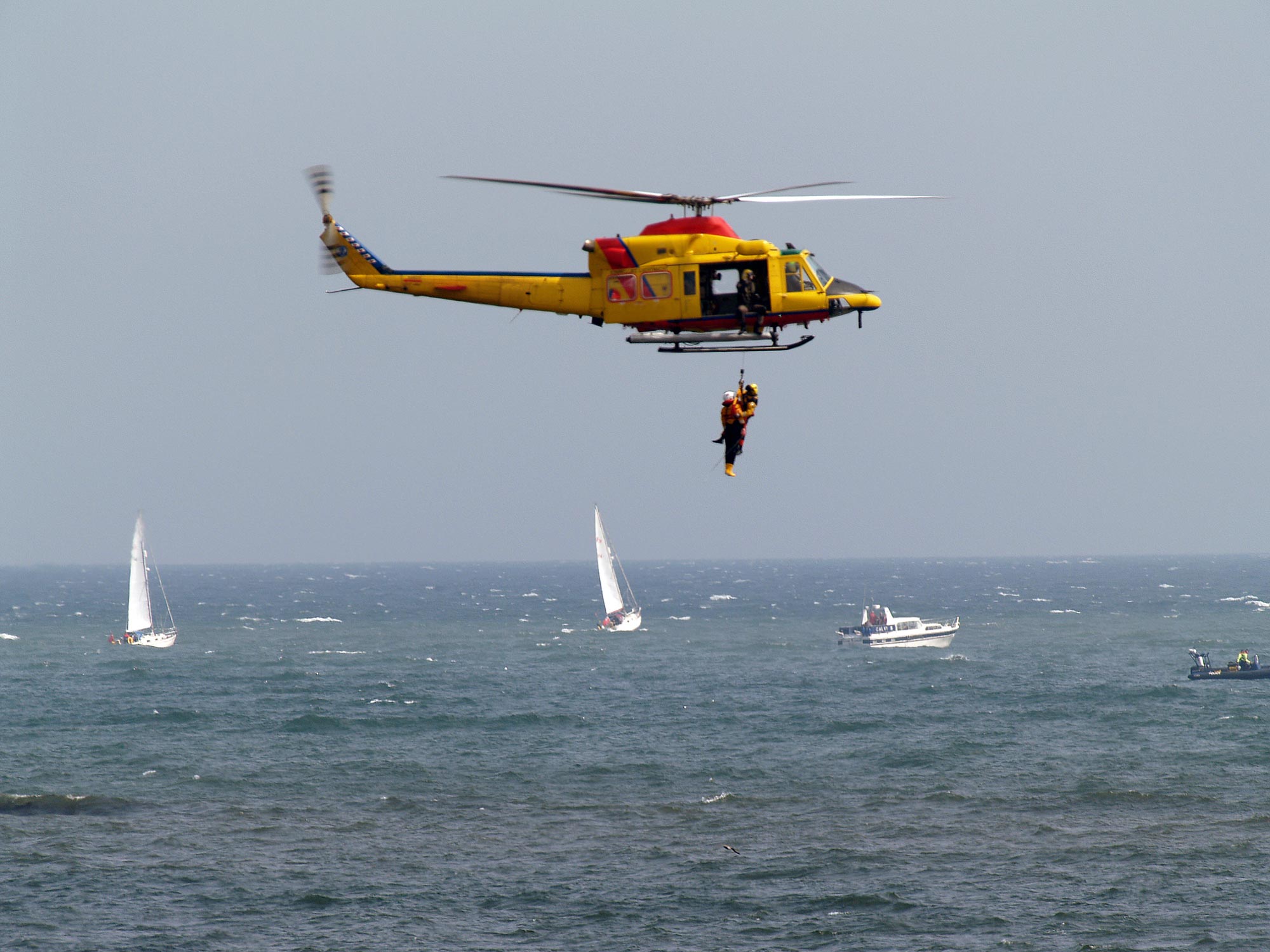
- Emergency Response: During an emergency or natural disaster, first responders use GPS for mapping, following and predicting weather, and keeping track of emergency personnel. In the EU and Russia, the eCall regulation relies on GLONASS technology (a GPS alternative) and telematics to send data to emergency services in the case of a vehicle crash, reducing response time. Read more about GPS tracking for first responders.
- Entertainment: GPS can be incorporated into games and activities like Pokémon Go and Geocaching.
- Health and fitness: Smartwatches and wearable technology can track fitness activity (such as running distance) and benchmark it against a similar demographic.
- Construction, mining and off-road trucking: From locating equipment, to measuring and improving asset allocation, GPS enables companies to increase return on their assets. Check out our posts on construction vehicle tracking and off-road equipment tracking.
- Transportation: Logistics companies implement telematics systems to improve driver productivity and safety. A truck tracker can be used to support route optimisation, fuel efficiency, driver safety and compliance.
Other industries where GPS is used include: agriculture, autonomous vehicles, sales and services, the military, mobile communications, security, and fishing.
What is GPS tracking for fleet management?
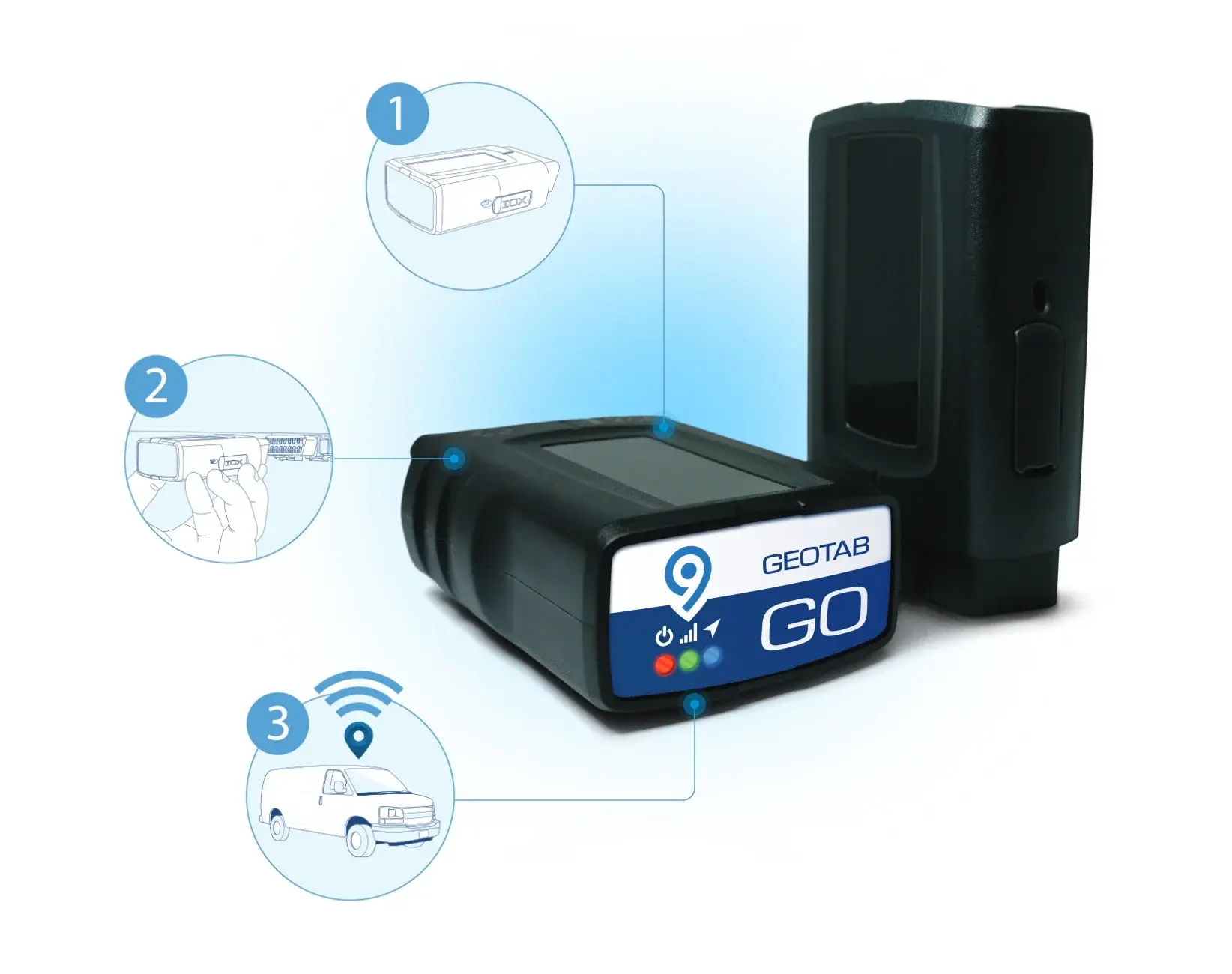
GPS tracking is the use of the Global Positioning System to monitor the real-time location, speed and movement of vehicles, assets or people. For fleet businesses, GPS tracking means installing a small GPS tracking device — also called a vehicle telematics device — into each vehicle. The device communicates with GPS satellites to calculate the vehicle's position and transmits that data back to a cloud-based fleet management platform.
Fleet managers can then view every vehicle on a live map, receive alerts for speeding or harsh braking, replay historical trip data, and generate reports on driver behaviour and fuel usage — all from a single dashboard.
GPS tracking systems are used by fleet businesses of all sizes in Malaysia, the Philippines and across Southeast Asia to:
- Reduce fuel costs by optimising routes and reducing idling time
- Improve driver safety by monitoring harsh braking, speeding and fatigue
- Increase vehicle utilisation by identifying underused assets
- Meet compliance requirements for hours of service and vehicle maintenance
- Protect vehicles against theft with real-time location monitoring
GPS tracking systems for business in Southeast Asia
A GPS tracking system for business combines GPS hardware, cellular data connectivity and fleet management software into one solution. The hardware — a GPS tracking device — is installed in each vehicle and captures data including location, speed, engine status and driver behaviour. That data is transmitted in real time to a web-based or mobile dashboard accessible by fleet managers anywhere.
Geotab's GPS tracking system is used by over 100,000 customers globally, including logistics operators, construction companies, utilities and government fleets. In Southeast Asia, Geotab works with local resellers across Malaysia, the Philippines, Singapore, Thailand and Indonesia to provide GPS tracking solutions tailored to local road conditions, compliance requirements and fleet sizes.
Key features of a GPS tracking system for business:
- Real-time GPS tracking: See every vehicle's exact location on a live map, updated every few seconds
- Route history and replay: Review where each vehicle has been, with timestamps and speed data
- Driver behaviour monitoring: Identify harsh braking, rapid acceleration and speeding events
- Fuel monitoring: Track fuel consumption across the fleet and identify waste
- Maintenance alerts: Set up automatic reminders based on mileage or engine hours
- Integration-ready: Connect GPS tracking data with existing ERP, dispatch and HR systems
How accurate is GPS?
GPS device accuracy depends on many variables, such as the number of satellites available, the ionosphere, the urban environment and more.
Some factors that can hinder GPS accuracy include:
- Physical obstructions: Arrival time measurements can be skewed by large masses like mountains, buildings, trees and more.
- Atmospheric effects: Ionospheric delays, heavy storm cover and solar storms can all affect GPS devices.
- Ephemeris: The orbital model within a satellite could be incorrect or out-of-date, although this is becoming increasingly rare.
- Numerical miscalculations: This might be a factor when the device hardware is not designed to specifications.
- Artificial interference: These include GPS jamming devices or spoofs.
Accuracy tends to be higher in open areas with no adjacent tall buildings that can block signals. This effect is known as an urban canyon. When a device is surrounded by large buildings, like in downtown Manhattan or Toronto, the satellite signal is first blocked, and then bounced off a building, where it is finally read by the device. This can result in miscalculations of the satellite distance.
A brief history of GPS
Humans have been practicing navigation for thousands of years using the sun, moon, stars, and later, the sextant. GPS was an advancement of the 20th century made possible by space-age technology.
GPS technology has been used globally throughout history. The launch of Russia’s Sputnik I satellite in 1957 ushered in the possibility of geolocation capabilities and soon after, the U.S. Department of Defense began using it for submarine navigation.
In 1983, the U.S. government made GPS publically available, but still kept control of the available data. It wasn’t until 2000 that companies and the general public gained full access to the use of GPS, eventually paving the way for greater GPS advancement.
For more on the history and development of GPS, see our post on the History of GPS satellites and commercial GPS tracking.
Global Navigation Satellite Systems (GNSS)
A GPS is considered to be a Global Navigation Satellite System (GNSS) — meaning it is a satellite navigation system with global coverage. As of 2020, there are two fully operational global navigation satellite systems: the U.S. navigation signal timing and ranging (NAVSTAR) GPS and Russia’s Global Navigation Satellite System (GLONASS). The NAVSTAR GPS consists of 32 satellites owned by the U.S. and is the best-known and most widely-utilised satellite system. Russia’s GLONASS consists of 24 operational satellites with three remaining as spares or in testing.
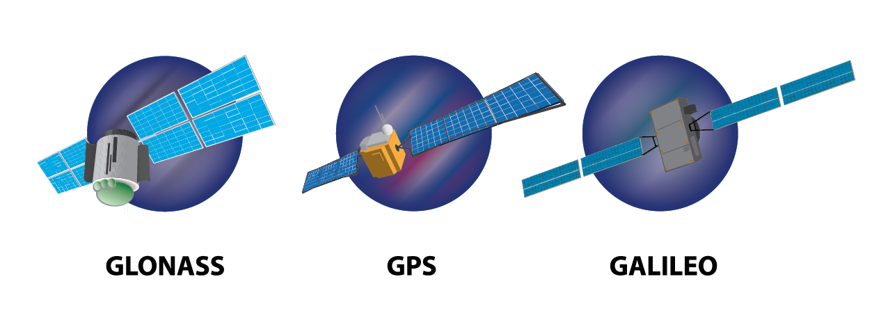
Illustration of GLONASS, GPS and Galileo Satellites.
Other countries are also racing to catch up. The EU, for example, has been working on Galileo, which is expected to reach full operation capacity by the end of 2020. China is also building the BeiDou Navigation Satellite System, with 35 satellites planned to be in orbit by May 2020. Japan and India are also well on their way with their own regional systems, the Quasi-Zenith Satellite System (QZSS) and the Indian Regional Navigation Satellite System (IRNSS), respectively.
GPS vs GNSS Devices
Though GPS is a subset of GNSS, receivers are differentiated as GPS (meaning GPS-only) or GNSS. A GPS receiver is only capable of reading information from satellites in the GPS satellite network, while the typical GNSS device can receive information from both GPS and GLONASS (or more than these two systems) at a time.
A GNSS receiver has 60 satellites available for viewing. While a device only needs three satellites to determine its location, accuracy is improved with a larger number of satellites. The chart below shows an example of the number of satellites available (shown in green), along with its signal strength (height of the column), to a GPS receiver. In this case, 12 satellites are available.
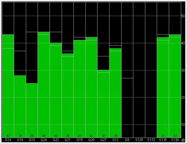
Typical GPS-only test board showing 12 satellite signals (green), using U-Center software.
A GNSS device can see more satellites, which helps improve device accuracy. In the chart below, there are 17 available satellites. Green bars are part of GPS and blue bars are part of GLONASS.
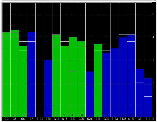
Typical GNSS test board showing 17 satellite signals (GPS = green; GLONASS = blue), using U-Center software.
A larger number of satellites providing information to a receiver enables the GPS device to calculate location with greater precision. More satellites give a device a better chance of getting a positional fix when the receiver has calculated the location of the user.
That being said, GNSS receivers have some drawbacks:
- The cost of GNSS chips are higher than those of GPS devices.
- GNSS uses a wider bandwidth (1559-1610 MHz) than GPS (1559-1591 MHz).This means standard GPS radio frequency components, such as antennas, filters and amplifiers, cannot be used for GNSS receivers, resulting in a greater cost impact.
- Power consumption would be slightly higher than with GPS receivers as it connects to more satellites and runs the calculations to determine location.
The future of GPS
Countries continue to build and make improvements to their GPS systems. Efforts worldwide are being made to increase accuracyand improve reliability and GPS capabilities.
For example:
- GNSS receivers are expected to become smaller, more accurate and more efficient, and GNSS technology is set to penetrate even the most cost-sensitive GPS applications.
- Scientists and rescue workers are finding new ways to use GPS technology in natural disaster prevention and analysis in the event of an earthquake, volcanic eruption, sinkhole or avalanche. For the COVID-19 pandemic, researchers are looking at using cellphone location data to assist with contact tracing in order to slow down the spread of the virus.
- The launch of new GPS III satellites will refine GPS accuracy to 1-3 metres, improve navigation abilities, and longer-lasting components as early as 2023. By broadcasting on the L1C civilian signal for interoperability with other satellite systems.
- The next generation of GPS satellites will include better signal protection, decreased susceptibility to signal jamming and more maneuverability to cover dead zones.
- The National Aeronautics and Space Administration’s (NASA) Deep Space Atomic Clock is set to use a powerful onboard GPS satellite to help provide better consistency in time for future astronauts embarking on deep space journeys.
The future of GPS tracking will likely be far more accurate and effective for both personal and business use.
Ready to set up GPS tracking for your fleet?
Geotab's GPS tracking system gives fleet managers in Malaysia, the Philippines and across Southeast Asia real-time visibility into every vehicle — from location and speed to driver behaviour and fuel use.
Frequently Asked Questions
GPS tracking is the use of the Global Positioning System (GPS) to monitor the real-time location, speed and movement of a vehicle, asset or person. A GPS tracking device installed in the vehicle communicates with orbiting satellites to calculate its exact position, then transmits that data to a cloud platform that fleet managers can access via web or mobile app.
A GPS tracking system is a combination of GPS hardware, cellular connectivity and fleet management software that allows businesses to monitor their vehicles and assets in real time. The system captures location, speed, route history and driver behaviour data, and presents it on a web-based dashboard. GPS tracking systems are used by logistics companies, utilities, construction firms and government fleets across Malaysia, the Philippines and Southeast Asia.
A GPS navigation system helps a driver find routes and directions from point A to point B — think of the GPS navigation app on your smartphone. A GPS tracking system is designed for fleet managers rather than drivers: it monitors where vehicles are, how they are being driven, and how efficiently routes are completed — even when the manager is not in the vehicle. Most commercial GPS tracking systems include navigation features as well.
A small GPS tracking device is installed in each vehicle in the fleet. The device receives signals from GPS satellites to calculate its position, then transmits that location data over a cellular network to a cloud server. Fleet managers log in to a dashboard — such as MyGeotab — to see all vehicles on a live map, set up alerts, review trip history and generate reports on fuel use, driver safety and vehicle health.
GPS tracking helps fleet businesses in Malaysia, Thailand, Singapore, Indonesia and Philippines reduce fuel costs through route optimisation and idle time reduction, improve driver safety by identifying harsh braking and speeding events, increase vehicle utilisation by showing which assets are underused, and protect vehicles from theft with real-time location monitoring. Many businesses report a return on investment within six to twelve months of deploying a GPS tracking system.
The Geotab Team write about company news.
Table of Contents
- What is GPS and how does it work?
- What are the three elements of GPS?
- How does GPS technology work?
- What are the uses of GPS?
- What is GPS tracking for fleet management?
- GPS tracking systems for business in Southeast Asia
- How accurate is GPS?
- A brief history of GPS
- Global Navigation Satellite Systems (GNSS)
- GPS vs GNSS Devices
- The future of GPS
- Ready to set up GPS tracking for your fleet?
Related posts
What Is ADAS? A Guide to Driver Assistance Systems for Philippine Fleets
October 21, 2026
5 minute read
What Is a GPS Jammer? Detection and Protection in the Philippines
October 20, 2026
5 minute read


How to maximise vehicle utilisation with a fleet management system in Southeast Asia
October 1, 2026
3 minute read


Building the Future of Fleet Management: Key Highlights from the SEA Partner Summit 2026
July 21, 2026
2 minute read