What is Geofencing? How Fleet Managers Can Use Location Boundaries to Cut Costs and Reduce Liability
Geofencing creates virtual boundaries around real-world locations, triggering alerts and reports when a tracked vehicle enters, exits or dwells in a zone.
July 21, 2026
•5 minute read
Definition
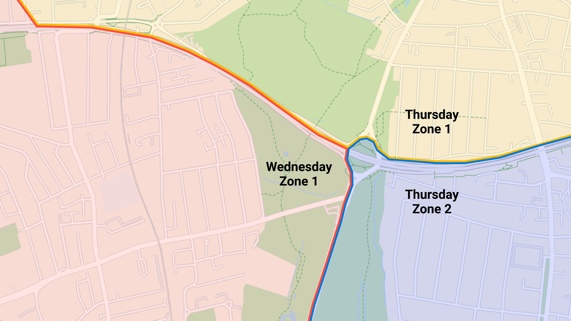
Geofencing is a location-based technology that uses GPS coordinates to create virtual boundaries around a physical area. In fleet management, a geofence triggers an alert, notification or report when a tracked vehicle enters, exits or remains within the defined zone.
What is geofencing?
Geofencing is a location-based technology that uses GPS coordinates to create virtual boundaries around any physical area. Geofences become operationally useful when they’re used with conditional logic rules in fleet management software. These rules can trigger specific actions, such as an alert or notification, when a tracked vehicle or asset enters, exits or remains within the defined area for a specified period.
Unlike standard GPS tracking, which shows fleet managers where a vehicle is, geofencing helps them identify when a location-based event requires action.
How do fleet managers use geofencing to optimise their fleet operations?
With geofencing, users can draw virtual perimeters around defined areas of work, customers’ sites, service stations, national borders, clean air zones, homes, and other operationally significant locations.
When combined with event reporting and notifications, geofencing can help fleets to:
- Monitor vehicle activity and route adherence
- Track and safeguard high-value assets
- Improve productivity and asset utilisation
- Comply with restricted zones
- Automate customer updates and operational reporting
Geofences help fleet managers monitor vehicle activity
With standard GPS tracking, fleet managers need to keep a constant eye on the map to check where vehicles are and whether drivers are following their planned routes.
Geofences remove much of this manual work. Fleet managers can establish zones around important locations and receive an alert only when a predefined event occurs, such as a vehicle leaving its route, entering an unauthorised area or remaining at a location longer than expected.
Creating geofences around customer locations also allows arrival and departure times to be recorded automatically. This can reduce reliance on manual timesheets, improve the accuracy of job records and reveal recurring delays for further investigation.
Geofencing protects high-value assets
Rental operators can use geofences to identify when vehicles cross national borders or leave an agreed operating area. Where a rental contract restricts the vehicle to a particular country or region, a near-real-time alert allows the operator to investigate the movement promptly and establish whether the vehicle is being used without authorisation.
Construction companies can use the same principle to protect mobile plant, trailers and other valuable equipment. A geofence around a construction site can trigger an alert if a tracked asset leaves the site unexpectedly, allowing the business to respond quickly to potential theft or inappropriate movement.
While geofencing doesn’t prevent theft by itself, it can considerably shorten the time between an unauthorised movement and the operator becoming aware of it.
Geofences improve productivity and asset utilisation
Fleet managers can create alerts when vehicles remain within a defined location for longer than an agreed period. This can identify extended stops at service stations, excessive time at customer premises or vehicles stuck at repair centres for longer than expected.
These insights provide the context needed to investigate the cause. A long stop might indicate an extended break, congestion at a customer site, or inefficient loading processes.
Home zones can also help fleets identify out-of-hours vehicle use or vehicles starting and finishing outside agreed working times. However, because home-based geofences relate closely to an employee’s private life, their use requires particular care under data protection law.
Geofences around depots can provide further event reporting, highlighting vehicles that leave late, return unexpectedly early or remain unused when they were scheduled for work.
Geofencing for compliance with restricted zones
Seven English cities currently operate charging Clean Air Zones (CAZ), while London has separate Ultra Low Emission and Low Emission Zones (ULEZ and LEZ). Scotland also operates Low Emission Zones in Aberdeen, Dundee, Edinburgh and Glasgow.
Managing the different vehicle classifications, emissions requirements and payment arrangements can create a significant administrative burden for fleets operating across several cities.
In London, for example, the ULEZ charge must be paid by midnight on the third day following the journey. If the payment is missed, the vehicle keeper risks receiving a Penalty Charge Notice.
By creating geofences around charging zones and linking them to vehicle emission standards, fleet teams can generate reports or alerts when a non-compliant vehicle enters a zone. Administrative teams can then confirm whether a payment is required and complete it within the permitted timeframe.
Geofences can also support access control at customer sites, construction projects and hazardous locations. An alert can notify managers when a vehicle enters a restricted area, allowing them to confirm that the driver and vehicle meet the relevant site requirements.
Geofences streamline customer reporting
Dispatch teams can use geofences to trigger automated customer notifications as a delivery vehicle approaches or arrives at a site.
This reduces the time spent providing manual progress updates and gives customers greater visibility of expected arrival times. Recorded entry and exit times can also support proof of attendance, service-level reporting and the resolution of disputes.
Geofencing vs basic GPS tracking — what's the difference?
GPS tracking provides the location data that geofencing relies upon. Geofencing then adds a management layer by applying rules to that data and notifying the relevant team when action may be required. Below is a summary of how the two differ:
| Geofencing | Basic GPS tracking | |
|---|---|---|
| Creates alerts when location-based rules are broken | ✓ | X |
| Reduces the need for continuous manual monitoring | ✓ | X |
| Triggers automated arrival or departure notifications | ✓ | X |
| Identifies vehicles entering restricted or charging zones | ✓ | X |
| Reports when a vehicle remains at a location beyond an agreed time | ✓ | X |
| Supports automated proof of attendance at customer sites | ✓ | X |
| Detects unauthorised out-of-hours or cross-border movement | ✓ | X |
Geofencing helps Tarmac to increase vehicle utilisation and reduce costs
Tarmac is a leading UK supplier of construction and building materials. Its fleet management team uses geofencing to help with two specific fleet management processes:
1) The operations team established geofences around their manufacturers’ dealerships, creating a notification if a vehicle doesn’t move for more than 48 hours. This alerts the fleet management team if a vehicle is off the road awaiting repairs and the garage isn’t working on it. By following up on these instances with the dealerships, the team has improved fleet utilisation rates.
2) Geofences are also utilised for the UK’s clean air zones, including London’s ULEZ and LEZ, with a customised rule triggering a daily summary report of all non-conforming vehicles that have entered these zones, so the admin team can make payments promptly and avoid the risk of fines.
What are the UK GDPR considerations for geofencing and vehicle tracking?
Geofencing relies on GPS location data. Where that information can be linked to an identifiable driver, it is likely to constitute personal data and must be handled in accordance with the UK GDPR and the Data Protection Act 2018.
Employers must have a clear and lawful reason for collecting location data and should only monitor vehicles to the extent necessary for the stated purpose. Legitimate uses may include protecting company assets, confirming service delivery, improving driver safety or managing the authorised use of company vehicles.
Drivers should be informed what information is collected, why it is needed, when tracking operates, who can view the information and how long the data will be retained. Access should be restricted to authorised users, and retention periods should reflect the purpose for which the data was collected.
Particular care should be taken when employees are allowed to use vehicles privately or take them home. A geofence around a home address can reveal more than whether a vehicle has arrived or departed. Over time, it may expose patterns relating to an employee’s movements, working hours and private life. Fleets should therefore consider whether the same objective can be achieved through less intrusive means and prevent unnecessary visibility of location data during authorised personal use.
A Data Protection Impact Assessment (DPIA) may be required where the planned monitoring is likely to create a high risk to individuals. Even when it is not mandatory, completing an assessment can help an organisation to document why the monitoring is necessary, proportionate and appropriately controlled.
How Geotab helps fleets optimise operations with geofences
MyGeotab combines vehicle location data with configurable zones, rules, reports and notifications, allowing fleet teams to manage by events, rather than continually monitor vehicles on a map.
Operators can create geofences and then define the event that should trigger action. Notifications can be issued when a vehicle enters or exits a zone, remains within it for too long, or moves outside an authorised area. This allows fleets to automate arrival reporting, identify avoidable delays, protect valuable assets and respond quickly to unauthorised use.
Geotab’s rules engine also helps turn location events into repeatable workflows. Fleet teams can receive alerts and notifications, produce event reports and combine zone activity with other vehicle information to understand not only where an event occurred, but whether it requires intervention.
For vehicles that are available for authorised personal use, Personal Mode provides an additional privacy control. Drivers or authorised users can enable Personal Mode for designated periods through the Geotab Drive app or MyGeotab. While enabled, GPS-derived information such as vehicle position, trips and speed profiles is not displayed.
Learn how Geotab’s fleet routing and dispatch solutions provide more ways to optimise your fleet’s performance
Frequently Asked Questions
Geofencing is the use of virtual boundaries around real-world locations. When a tracked vehicle enters, leaves or remains within one of these areas, fleet management software can trigger an alert, notification or report. This allows fleet teams to monitor events without continually watching vehicle locations.
Geofencing needs four things for it to work for vehicle management: 1. Creation of a virtual boundary for a specific physical location, the geofence. 2. A GPS tracking device in the vehicle that uses cellular data. 3. A fleet management system that continuously monitors the position of the device or asset in relation to the boundary. 4. Pre-defined actions that are triggered when the monitoring system detects a device or asset crossing the virtual boundary and any other custom rule.
Yes. By creating a geofence around all of the UK’s Low Emission Zones (LEZ) and Clean Air Zones (CAZ), and then triggering alerts or reports when certain vehicles enter these zones, fleet management teams can keep on top of paying the daily charges and avoid costly Penalty Charge Notices.
GPS tracking shows where a vehicle is or has travelled. Geofencing applies rules to that location data and triggers an action when the vehicle enters, exits or remains within a defined area. This turns passive location visibility into an event-based management tool, reducing the need for fleet teams to continuously monitor vehicles.
Geofencing and GPS vehicle tracking can be lawful in the UK and Europe, but their use must comply with the applicable data protection and employment rules. Organisations need a valid lawful basis, a clear and legitimate purpose, and monitoring that is necessary and proportionate. Drivers should be told what data is collected, why it is used, when tracking operates, who can access it and how long it will be retained. Employers should take particular care with vehicles used privately or parked at employees’ homes, because continuous tracking may intrude into private life. Privacy controls that conceal location data during authorised personal journeys can help, but the exact legal requirements and employment rules vary between European countries.
Table of contents
- What is geofencing?
- How do fleet managers use geofencing to optimise their fleet operations?
- Geofencing vs basic GPS tracking — what's the difference?
- Geofencing helps Tarmac to increase vehicle utilisation and reduce costs
- What are the UK GDPR considerations for geofencing and vehicle tracking?
- How Geotab helps fleets optimise operations with geofences
Other Stories
August 5, 2025
5 minute read
A Guide to the Estimated Time of Arrival (ETA)
October 7, 2024
2 minute read
Guide to digital tachograph cards
October 7, 2024
3 minute read