What’s new in MyGeotab — Version 2002
Welcome to our latest summary of updates in MyGeotab.
Jul 12, 2023
Geotab Users: To verify your version: go to MyGeotab > Administration > About, and check the build number, (e.g. 5.7.2002.xxx release).
Resellers: Review this post for important changes affecting your customers and note any recommendations.
Sign up for Geotab news
Stay up to date on what’s new. Please subscribe to the Geotab newsletter to get these update posts emailed to you.
✱ END OF LIFE NOTICE: Please take note, starting with our next release of MyGeotab, i.e. version 2003, we will no longer support Internet Explorer 10. This notice follows the Microsoft announcement which ended support for Internet Explorer 10 and older, earlier this year.
Users
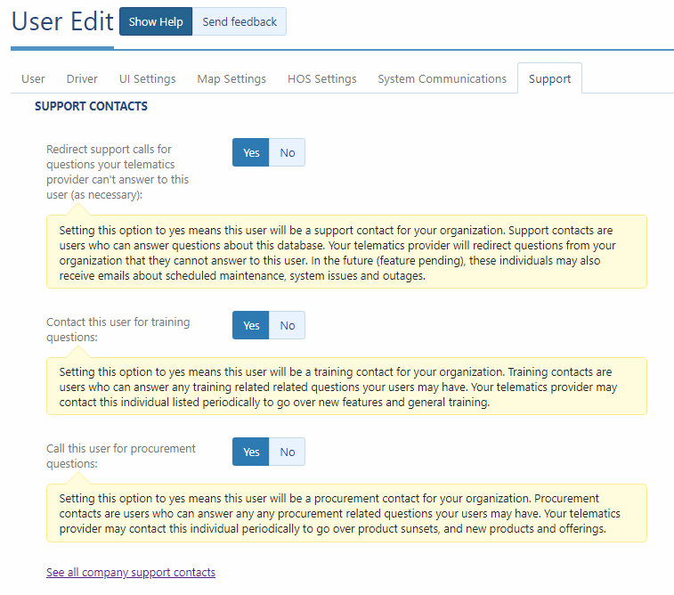
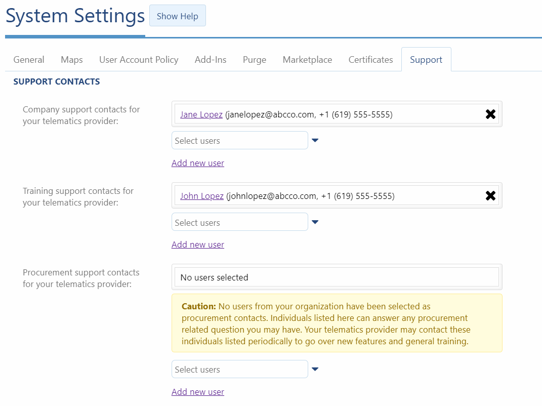
Designate your support, training and procurement contacts for your organisation
Assign key experts from your organisation who can answer questions and solve problems! As professionals in areas of training, procurement and technical support, these individuals can share knowledge and identify tools to help meet your needs in the Fleet Management Application. They can also receive important updates about new features, and other areas we are working on to support your business.
✱ NOTE: Individuals designated as support contacts must provide a phone number, since we may redirect calls if we cannot assist a user from your organisation who needs help.
✱ NOTE: The Contacts feature is an optional setting, and not required to be enabled.
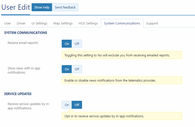
New System Communications tab on User Edit page
We added a new System Communications tab which combines email reports, in-app notifications and service updates, into one convenient view! Use in-app notifications (formerly called: news notifications) to stay up-to-date with service updates and other news, all without leaving the Fleet Management Application.
Added a field for phone number on the User Edit page
You now have the option to include a phone number on the User Edit page.
Note: For users designated as Support Contacts, a phone number is required.

Choose any day as the “start of week”
You can now choose any day to start your work week. Previously, this was limited to Saturday, Sunday and Monday. Fleets who start their work week on days other than Saturday, Sunday or Monday will find this feature useful.
Change authentication types for your users
In today’s world, business can be done from anywhere. The authentication game is changing and so are we! Currently, we support three authentication types:
- Basic — HTTP-based authentication using the HTTPS/SSL security methods.
- SAML— Single sign-on (SSO) authentication.
- MyAdmin — Uses your MyAdmin credentials for access to MyGeotab.
Users can now transition between three authentication types:
✔ SAML > Basic
✔ Basic > SAML
✔ MyAdmin > Basic
✘ Basic > MyAdmin *You cannot transition from Basic to MyAdmin authentication type.
Map
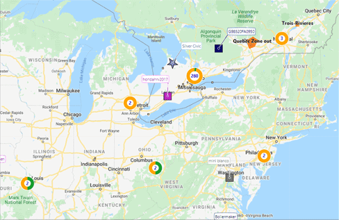
Display up to 10,000 vehicles using our new clustered Map view (Feature Preview)
Large fleets can now display up to 10,000 vehicles at a time in one convenient view on the Map. Using a clustered approach, we added tools to show you where your vehicles are, which vehicles have stopped (indicated in orange), and which vehicles are driving (indicated in green). If you have 500 vehicles or more, use the Select all feature to summarize your fleet using easy-to-read pie charts.
We want your feedback! Please use Rate & Review to tell us how we did.
Updated pop-up when assigning a driver to a vehicle on the Map
Previously, when assigning a driver to a vehicle on the Map, users had the option to assign a default driver to the vehicle. We understand that this may have been confusing, giving users the false impression that the default driver would remain assigned to the vehicle indefinitely. To simplify, we revised our labels to better reflect available options for driver assignments.
The driver will be assigned to the vehicle for all trips until:
- The driver is assigned to another vehicle.
- Another driver is assigned to this vehicle.
- The driver is unassigned from this vehicle.
Assigning a new driver to this vehicle, will remove the current driver of this vehicle. If the new driver is assigned to another vehicle, they are likewise, removed from that vehicle, and assigned all trips associated with this vehicle.
.png)
Updated information pop-up when assigning a driver to a vehicle on the Map
The live Map now displays new drivers as soon as they are assigned to a vehicle. Previously, new drivers were only updated when the next trip occurred.
Messages
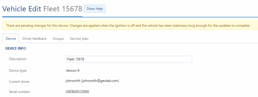
New “pending changes” message
When device settings are updated on the Vehicle Edit page (e.g. turning on “Periodically wake GPS”), users will now see a message across the top of the on the page explaining that changes are pending. When the device has been updated and changes are made, the message disappears.
Updated system notices
We streamlined our system notices when changes are made to users settings. Previously, users who subscribed to system notices received an email with “before and after” values when user properties were modified. The new notifications will simply display the date, and the properties that were modified.
Note: This change has also been implemented on the existing Geotab build 5.7.2001.xxx for security considerations.
Added a message about billing when removing a device
To help prevent unnecessary billing issues, we added a new note when removing devices from your database. You will now be prompted to contact your Reseller when removing a device to ensure your billing is updated appropriately.
Added Diagnostic Code to all notification templates
The Diagnostic Code is now available as a token to give users greater insight into their fleets. Users can use this token in combination with the existing diagnostic token for a complete picture of the engine diagnostic.
Electric Vehicles
EV Charging Report is out of Feature Preview
The EV Charging report is now available by default for everyone. Thanks to the great feedback we received during the Beta phase, we feel confident in adding this report to our built-in suite of default reporting options.
EV Charging Activity on the live map is out of Feature Preview
EV Charging Activity is now available on the live Map by default for everyone. This feature supports real-time battery charge % (or state of charge) while driving and charging, and displays indications of whether an EV is actively charging for supported EVs. Thanks to the great feedback we received during the Beta phase, we feel confident in adding this feature to the default Map options for all users.
Reports
New columns available on the Device Excel report
AutomaticVehicleManagement and HosSettings are now available columns on both standard and advanced Device reports. You can find these new columns in the Data tab of these reports.
General Improvements
Added a Rate Plan column in the Vehicle page (Feature Preview)
For quick and convenient access to all available options, we have added a Rate Plan column to the Vehicles page.
Known Issues list has been removed
The Known Issues list has been removed from MyGeotab. If you have an issue or need help, you can always visit the Geotab Community or create your own post. Keep an eye on upcoming releases, as we may revisit this feature in the future.
UI updates and bug fixes
- Added raw data points to all graphs.
- Updated the Engine Faults page to show the checkbox by default, so users understand they can dismiss faults.
- Updated the list of Audit Log types to ensure all types can be searched.
MyGeotab SDK updates
The following updates and properties have been added to the software SDK.
NuGet
! IMPORTANT: A bug has been identified with NuGet packages older than version 5.7.2002, which can lead to serialization errors when a previous version received a new device plan value. Please update to the latest NuGet package to establish compatibility.
Map Add-In
Users can now create a Map Add-In without using the view panel on the right. For quick tasks such as adding icons or text to the Map, simply use the “noView”:true parameter in your configuration file. e.
{
"page": "map",
"noView": true,
"title"": "Some title",
"mapScript"": {
"script": "..."
}
}
You can now hide Vehicle State & Groups information from the tooltip when hovering or selecting vehicles on the Map. See the example below.
service.tooltip.setConfig({
device: { state: false, groups: false }
});
StatusData and LogRecord
In the 2001 release and earlier, we interpolate between points when using status data and log record API. When a date is requested that is less than or greater than the data, we return the last value with the date of the time requested. To minimize confusion, we now return the last value with the correct dateTime.
Users
- Added the IsExemptHOSEnabled property to indicate whether the user is allowed to use HOS Personal Conveyance.
- Added CompanyName, CompanyAddress, and CarrierNumber properties to store company and carrier information.
- Added CountryCode, PhoneNumber, and PhoneNumberExtension properties to assign a phone number to a selected user.
DutyStatusLog
- Added the PC_Exempted property to indicate the status of a driver.
- Added DeferralStatus, and DeferralMinutes properties to define the duty status deferral and deferral minutes.
DVIRLog
- Most DVIRs are performed as either Pre or Post-trip inspections. To include middle-of-the day scenarios such as discovering new defects, or performing additional inspections, we have added a new In-trip inspection type.
- Added LogType and DefectList properties.
Rules
- Added HosEnabled and HosDisabled to recipientType to automate HosEnabled/HosDisabled duty status logs using rule notifications. For example, when an exception event occurs, add an HosEnabled or HosDisabled duty status log at the same time as the event for an unidentified driver.
- Added NoPreDVIRCheck and NoPostDVIRCheck to ConditionType when no Pre or Post-trip DVIR is performed between work days.
- Added SpeedLimitAsMeasurement property to the ConditionType to create rules that only apply to posted road speeds that are greater than, or less than a specified value. For example, it may be more important to alert the driver when the vehicle is travelling less than 10mph, or greater than 10mph on a highway, than it is on a city street.
- The NoDVIRCheck ConditionType is obsolete and will be removed in a future version. Please use NoPreDVIRCheck and NoPostDVIRCheck.
Drivers
- Added LicenseProvince and LicenseNumber properties.
- Added RestBreakNeeded, OffDutyNeeded, DaySummaries, WorkdaySummaries and CycleSummaries properties to DriverRegulation.
SecurityIdentifier
Added the SystemSettings property.
Zones
Added the ZoneTypes property for enumeration of zone types for a given zone.
GO9
Added the ObdAlertEnabled property to allow users to enable/disable OBD alerts on their vehicles.
GoDevice
- Added the ParameterVersionOnDevice property to track the current parameter version on the device. The current ParameterVersion property communicates the parameter version to the device; however, parameter updates are not always immediate.
- To prevent mismatches based on system clock settings, we have prevented activeFrom from being greater than activeTo when adding a device.
Generator Add-In version 3.0
We have modernized the Add-In scaffolding, development and packaging tool to use more current techniques and features:
- Now using webpack.
- Now using Puppeteer for browser testing.
- UI now shows a collapsible navbar.
- Can now toggle multi-language support.
- Can now toggle blur and focus events to simulate leaving and re-visiting the Add-In page.
For more information visit GitHub at https://github.com/Geotab/generator-addin
Mg-api-js version 2.0
This major release merges the API wrappers mg-api-js (previously browser only version) and mg-api-node (previously Nodejs only version) into a single project:
- Uses single js library for nodejs or browser.
- Supports Async promises and legacy callback behavior.
- Simplifies authentication process, no more hard-to-understand callbacks.
- Optional lower-level control over http response.
For more information visit GitHub: https://github.com/Geotab/mg-api-js
Other SDK Updates
Search by DeviceSearch.Groups property using BinaryDataSearch.
- Removed the DiagnosticCategory object from the SDK reference page. This is a legacy object that is no longer in use.
- Updated the ExternalDeviceShutdownDelay object to display values in minutes rather than seconds.
- Added a sample for getting fuel tax details using the API runner.
- Feature preview items now marked as Beta.
- Added a hardware Add-On Data Types section to the SDK.
Contributors:
Vik Sridhar, Product Engineering Manager, MyGeotab, Inshaal Badar, Senior Content Writer, Technical Writing Team.
See also: What’s new in MyGeotab — Version 2101
The MyGeotab and Technical Writing Teams write about MyGeotab updates for Geotab.
Related posts

Geotab AI-powered dash cams: Compare GO Focus Plus and GO Focus Pro
July 12, 2026
6 minute read

Geotab GO Focus Plus Camera Rules, Thresholds, and Event Buffers
February 24, 2026
1 minute read
Sustainability Centre: central hub for sustainable fleet management
January 28, 2025
2 minute read