What’s new in MyGeotab — Version 2103
Welcome to our latest summary of updates in MyGeotab.
Sep 1, 2022
Geotab Users: To verify your version: go to MyGeotab > Administration > About, and check the build number, (e.g. 5.7.2103.xxx release).
Resellers: Review this post for important changes affecting your customers and note any recommendations. If you have suggestions for improvement, please leave a comment below.
Sign up for Geotab news
Stay up to date on what’s new. Please subscribe to the Geotab newsletter to get these update posts emailed to you.
✱ NOTE: The images shown here are for illustration purposes only, and may appear different in the software as we approach the final release.
Do you have questions about this blog post? Are you interested in providing us with feedback? We’d love to hear from you, please email us at mygproduct@geotab.com.
General
Odometer and distance calculation improvements
Odometer is used throughout your MyGeotab database in Trips History, Assets, Rules, Reporting and more. Geotab has overhauled how odometer and distance is calculated and stored with the end goal of improving the speed and accuracy of our odometer reporting everywhere in the application, including within HOS (Hours of Service). These changes will start rolling out in this release, and continue in subsequent releases.
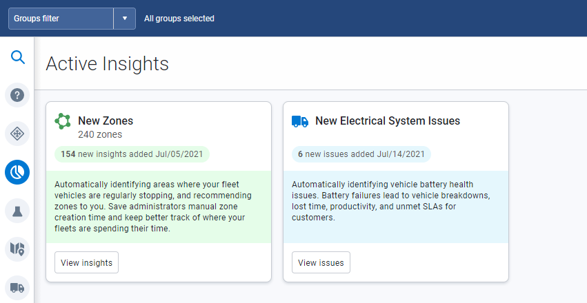
Active Insights now available to all users (Feature Preview)
For fleet managers with limited resources, Active Insights utilizes Geotab's rich data resources to provide clear and compelling insights into your business. Using our data analysis and AI models, Active Insights helps turn your data into measurable cost savings, with recommendations on what you can do to optimize your fleet. Visit the Active Insights page to start your data story today! In this release, we are introducing two powerful Insights, with more to come!
- Intelligent Zones — Automatically creates and manages new zones in MyGeotab. This Insight uses vehicle stop history to locate and recommend new zones. Users of MyGeotab can save time by importing recommended zones instead of creating them manually.
- Electrical System Rating (ESR) — Measures the health of your vehicle’s electrical system to provide an Electrical System Rating (ESR) on a scale from 0 to 100. ESR scale is based on four status categories; Good, Fair, Caution, and Poor. Caution indicates that maintenance should be scheduled for the vehicle; while Poor indicates that the battery is likely to fail. The ESR score is calculated daily for every vehicle in the fleet, and can be viewed on the Engine Diagnostics page.
For more information on how ESR is calculated, and the criteria involved, see our Electrical Systems Rating Summary presentation.
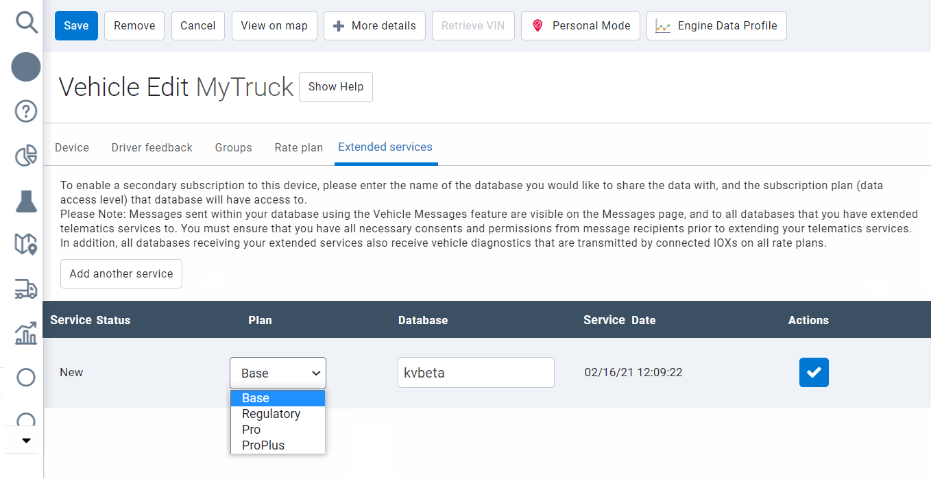
Extendable Services now out of Feature Preview
Extendable Services is out of Feature Preview and now available to all users! Extendable Services is a secured data sharing technology that allows users to collaborate with trusted business partners by extending their telematics data to other MyGeotab users. For example, users can extend safety and performance-driven data to insurance providers to save on coverage, or extend engine diagnostic data with maintenance providers to save on repairs. Extendable Services starts with a transaction between two MyGeotab users; a user from a Primary Database who makes a request to extend telematics services to a user from a Target Database, who accepts or rejects the request based on the needs of their business.
To learn more about Extendable Services, please refer to our User Guide.
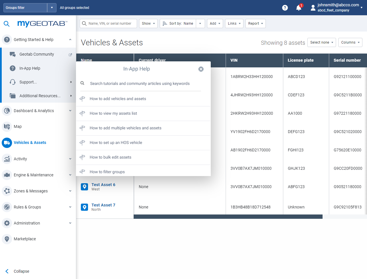
In-App help
In-App Help is a self-serve, self-supporting help and onboarding center, where users can view how-to videos, search Geotab Knowledge Base articles, and follow guided tutorials — all without leaving the application. Need help adding new assets or using compliance tools? In-App Help uses live features to walk you through each step. Growing your business? Let In-App Help onboard your Customers while you manage your fleet. At Geotab, empowering our users is what we do. So go ahead, try it out, and tell us what you think. We’re excited, and we hope you are too.
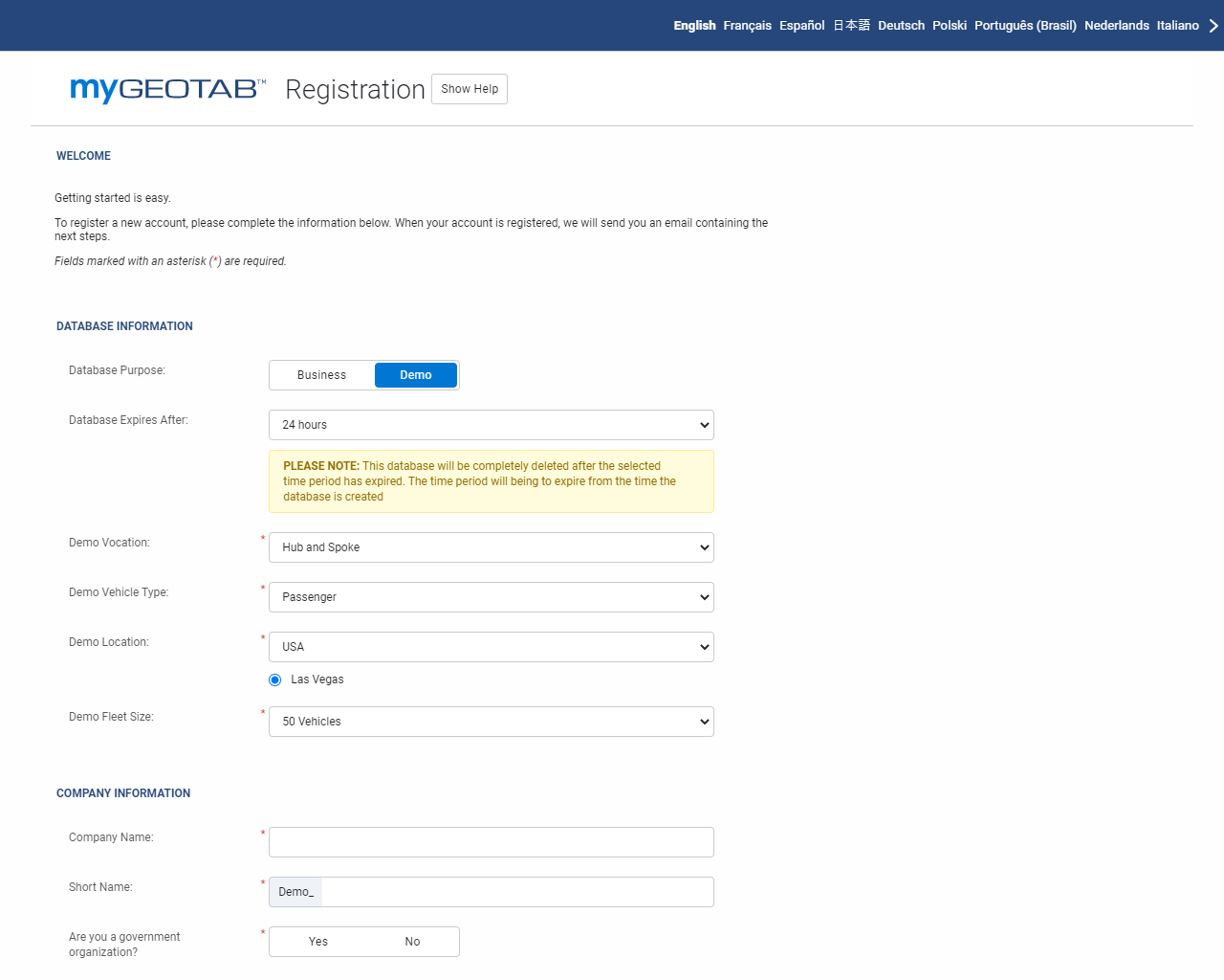
New MyDemo Database
Introducing MyDemo! MyDemo is an on-demand demo database for Geotab Partners and Integrators with 24/7 access, and real-time data. Partners can use MyDemo to prospect for customers, and build opportunities; while Integrators can use MyDemo to test new solutions and integrate their services. Setup is easy, just visit the MyPreview Registration page, choose a dataset, and set an expiry period. When the expiry period is reached, the database is deleted automatically. Need a new one? Simply return to the Registration page and start again!
Pagination for Assets and Zones
We've removed the maximum limit for fleets with over 500 assets, users or zones. Users can now view all entities without limits by navigating through pages using the forward or back arrows. We still recommend that you use Groups to manage your fleet, and filter your lists to display preferred assets.

Welcome message for new users
New users to MyGeotab will now see a special message from Neil Cawse, Geotab CEO, about Geotab’s mission, and how we can help you make the most out of your Geotab experience. Stick around after the message for an interactive tour on how to find what you're looking for using our easy navigation features.

Vehicles & Assets
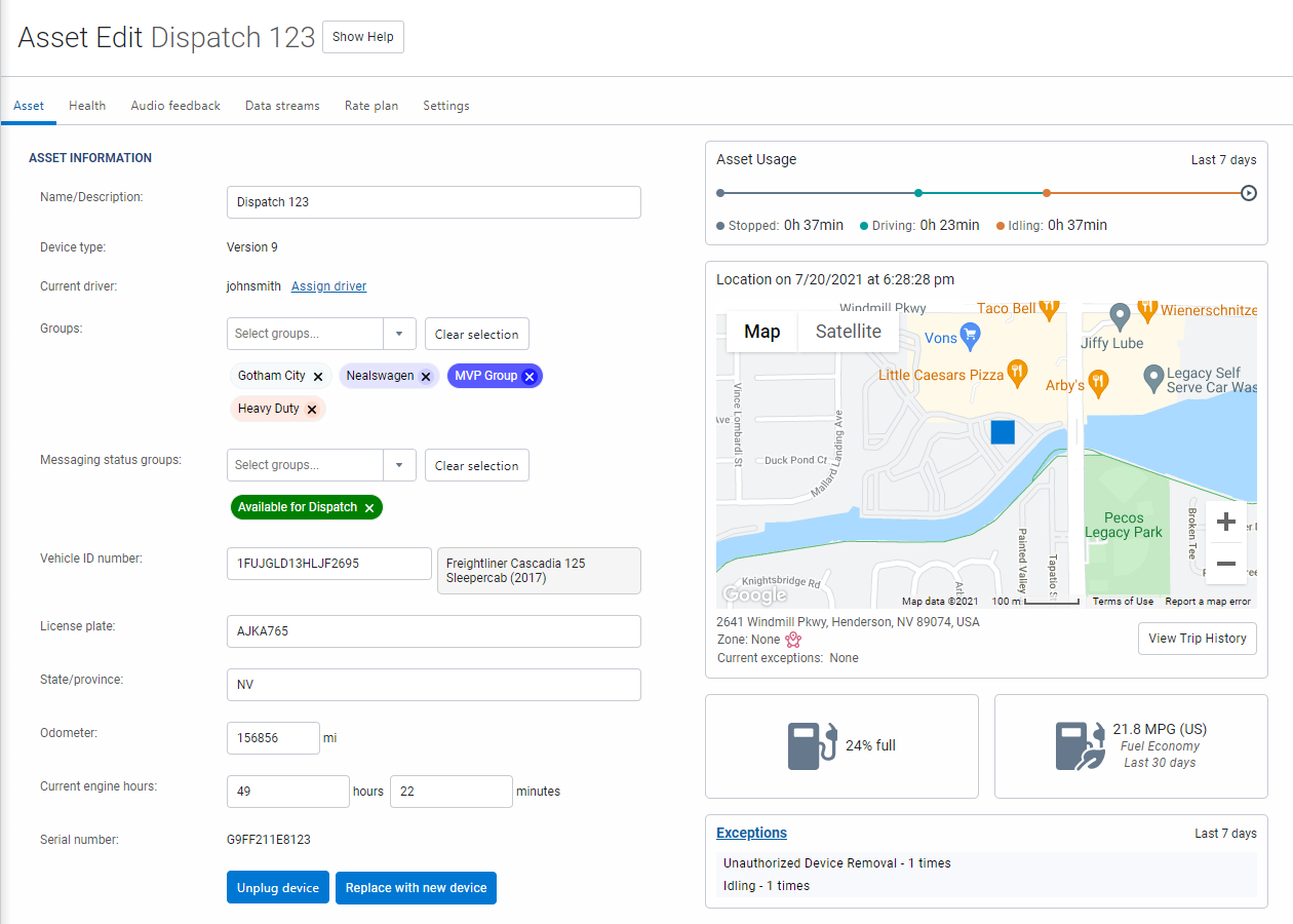
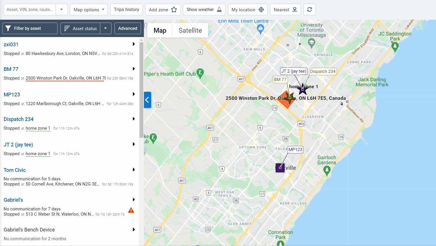
New Asset Edit page (Feature preview)
For busy users looking for faster ways to manage their assets, we've updated our Asset Edit page to provide a more compact and complete view of your assets. By consolidating important information into one page, navigation is reduced, so you can take action faster.
The tabs on the Asset Edit page include the following information:
- Asset: Includes a quick summary of the asset, the current driver, how it’s being used, its current location, groups, fuel consumption and more.
- Health: Reports on the health of the asset, including active faults, maintenance history, upcoming events, inspection logs and more.
- Audio feedback: Previously called Driver feedback, Audio feedback now includes GOTALK settings, and other usability improvements that better display what options are available.
- Driver Identification Reminder Duration: Available on GO9 devices and newer. The duration of the Driver Identification Reminder can be set under the Audio Feedback tab.
- Extendable services and Rate plan: No changes.
- Settings: Groups settings under one tab versus multiple tabs and More buttons.
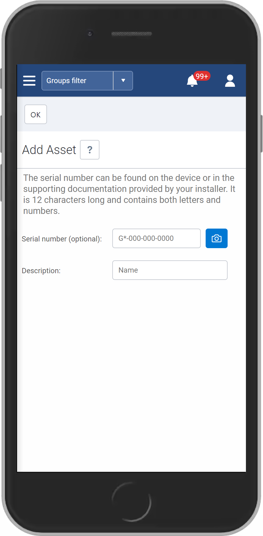
Barcode scanning for faster entry of serial number
You can now use the camera on your mobile phone to scan the serial number on your GO device.
Rules & Exceptions
OEM devices
To better capture OEM acceleration data, we have improved our OEM data collection and processing capabilities to more accurately reflect OEM acceleration events.
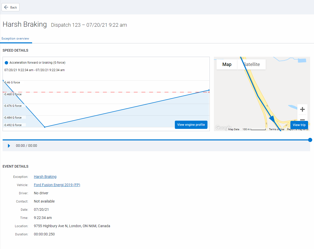
New Exceptions page (Feature Preview)
We've added a new Exceptions page with flexible tools and visualizations designed to provide meaningful insights into your business. Click an event to view details such as location, duration and driver contact info. Additional features such as event status, and the ability to include images, PDF files, and annotations will be introduced in a future release.
Map
Clustered map view
Clustered Map view is out of Feature Preview now available for fleets of all sizes! While in preview, we set limits of 500 assets or more. Due to popular demand, fleets of all sizes can now enjoy additional insights using the Clustered Map view.
Nearest assets
MyGeotab now uses real-time traffic data to calculate the distance between a selected location and the assets nearest to that location. Nearest assets technology uses a routing service to locate up to five of the closest assets within a 50-mile radius, then calculates the distance and the estimated time of arrival based on live road conditions. Users will notice a significant improvement over previous functionality, which calculated nearest assets using simple straight line distance. 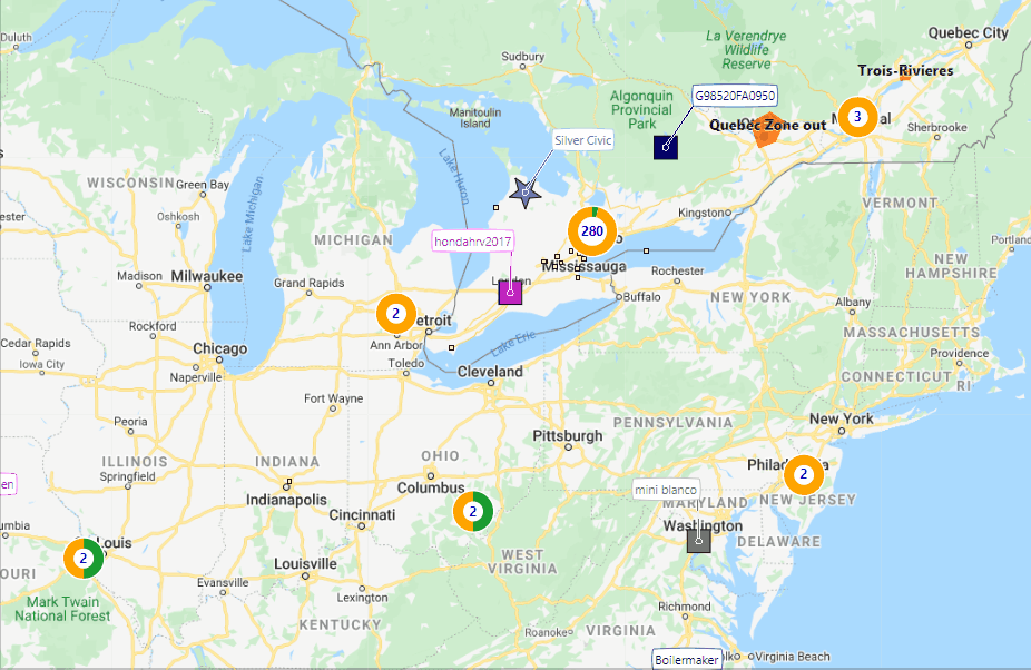
Area Activity feature
The Area Activity feature is out of Feature Preview and now available by default. Use the Area Activity feature to create a timeline of activity including the locations you have visited, and the routes you have travelled. Just zoom in to an area, click a location, select Area Activity, and enter a date and time. Use the Area Activity feature to investigate pick-up or delivery disputes, fleet activity over time, or simply to track day-to-day operations.
✱ NOTE: You may need to adjust your zoom level before the Area Activity feature is visible. You can search for a period of up to 72 hours from a particular date and time.
Maintenance
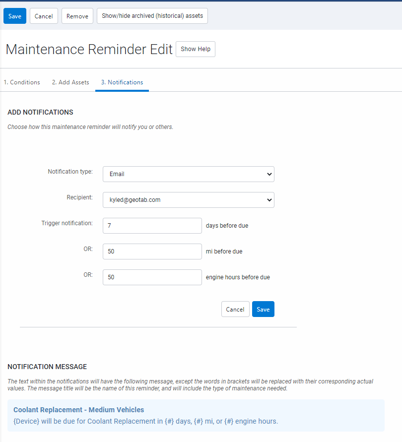
Maintenance reminders now available to all users
At Geotab, we work hard to create simple and efficient tools that make sense for your business, and your feedback is an essential part of that process. Over the past year, we have heard from a lot of you as we worked to improve our maintenance features. Now, with your endorsement, Maintenance Reminders is out of Feature Preview and available to all users by default.
Notable highlights include:
- Improved user experience.
- Addition of costs and multi-currency support.
- Support for ad-hoc maintenance logs.
- Bulk import of previous maintenance logs.
- Automatic notifications when approaching maintenance due dates.
Installation
Revamped Device Installation History page
For faster access to installation details, we have added new filter options to the Device Installation History page. Users can now filter on date range, refine results, and show/hide columns.
The Standard and Advanced Excel reports have also been updated to contain the following options:
- Asset serial number
- Date of installation
- Asset name
- License plate
- VIN
- Make/model
- Service performed
- Installer
- Installation company
- Work reference
- Harness (only in Advanced)
- IOX (only in Advanced)
- Auxiliary port(s)
- Comment or additional harness
- Odometer
- Engine hours
- Last device communication
- Last valid GPS record
- Last valid engine record
- SIM active
- Engine protocol
- Possible issues
- Result comments
- Installation comments
- Installation photo 1 (only in Advanced)
- Installation photo 2 (only in Advanced)
- Installation photo 3 (only in Advanced)
- Installation photo 4 (only in Advanced)
Reporting
Interactive Charts (Feature Preview)
Interactive Charts lets you visualize, create and display interactive widgets from Excel reports. Widgets, such as the Watchdog Report, can be displayed on your Dashboard, then actioned in Vehicles & Assets, just a few clicks away. Monitoring the health of your assets is important, and with Interactive Charts, it's now easier than ever.
The report types below will now have a new Interactive Chart option in the settings:
- Device Report
- Exceptions summary
- Trips detail
- Risk management
Audit log types for Dashboard and Email Reports
To prevent users from having to add manual filters to Excel reporting output, we have added Audit type filters on scheduled Email and Dashboard Reports. For added usability, this also reduces file size.

Improved engine status reporting
As promised in our 2102 release blog, We continue to customize our Engine Measurements feature, with new reporting options for regional units of measurements. Based on user profile settings, Excel reporting output will feature data in the regional units selected, no conversion required!
New custom column for Fuel and EV Energy Usage Report
We have added a new custom EngineStatusStatisticsGpsDistance column to the Fuel and EV Energy Usage report. To add the new column, go into the data sheet in the Excel report, and add the column header: “EngineStatusStatisticsGpsDistance”. The EngineStatusStatisticsGpsDistance column will now populate the total GPS distance of all vehicles in the fleet. To share your feedback with us, contact mygproduct@geotab.com.
Other
- For databases on the Brazilian platform, a new EULA is now available
- Changed sender name for automated emails from noreply@geotab.com to MyGeotab
- Renamed Links button to Installations on Vehicles & Assets page
- Enhanced audit log capability to include both original values, and new values set by drivers when editing NFC fields
- Users must select a jurisdiction when registering a new database
- Updated state of charge notification token value to be a whole number without decimals
- Added AiModel Source to the Diagnostics page
- Added LEVC (London Electric Vehicle Company) OEM faults to MyGeotab
- Added support for Shapefiles in Public Works Route Completions. The Shapefile option replaces the Excel option in Route Import, as the default
MyGeotab/Geotab Drive SDK and Add-In updates
Add/Set<FuelTransaction
Fuel transactions must be unique when comparing all fields (excluding sourceData) against existing transactions.
CompanyDetails
Added “jurisdiction” property.
CreateDatabase
The CreateDatabase API now requires user-selected jurisdiction. The jurisdiction is the place of residency for Customer data, maintenance hours, and other information (e.g.U.S., EU). This was previously inferred from the selected timezone. To maintain backwards compatibility, timezone can still be used to infer jurisdiction. However, all users are encouraged to provide a jurisdiction as part of the CompanyDetails provided to the CreateDatabase API.
CustomVehicleDevice
Added "fuelTankCapacity" property.
DiagnosticType
Added "LevcFault".
takePicture
The Drive App Add-in can now access the device camera to take a photo. Users can also upload photos from the mobile device.
DriverRegulation
Added "CurrentDutyStatus" representing the latest "DutyStatusLogType" affecting availability or violations.
DutyStatusViolationType
Added "EwdRest", "EwdWork", and "EwdWorkExemption" (formerly "Work" and "WorkExemption").
DVIRLogSearch
Added "LogTypes" property for searching by list of DVIRLogType.
ExceptionEvent
Exception events can be deleted when new data arrives from a device that, when evaluated against the same rule conditions, invalidates the previous state of the exception. For example, a speeding exception is generated for a street with a 40mph speed limit beside a highway. As more GPS data arrives, it becomes clear the vehicle is on the highway, not the service road, so the exception is invalidated. This is a problem for users who continuously request ExceptionEvent data because they are unaware when an exception is invalidated, and deleted at a later date.
To resolve this issue, two new properties have been added to ExceptionEvent; "lastModifiedDate" and "state". These properties determine if the exception event is invalidated instead of deleted. This means that when a new GetFeed request is made, the user sees the updated record and can adjust their records accordingly. Invalidated exceptions will no longer be removed immediately.
✱ NOTE: This feature is not enabled by default. You must pass the search parameter "includeInvalidated" in the request to Get or GetFeed to return invalidated exception events. The "state" of these exceptions will be "Invalid".
ExceptionEventSearch
Added "includeInvalidated" property.
ExceptionEventState
New object representing the state of the exception event. Possible states are "Valid" and "Invalid".
Generator Add-in
Generator-addin updated to mock drive add-in camera API features.
Group
Group objects in some instances had "color" and "children" properties partially populated when nested in another object (ex device.groups). This is fixed, so they are no longer populated when groups are nested in group linked entities.
HosRuleSet
Added "CaliforniaPropertyShortHaul" and "CaliforniaPropertyShortHaulWithRest" to HosRuleSet.
Jurisdiction
New enumeration representing the Jurisdiction of a database.
MediaType
Added "Application" media file type. This is to support PDF file types in MediaFiles.
RadioDownloader, RadioData and related objects are removed
All Radio Downloader related objects are removed as Geotab deprecates all RF functionality.
SecurityIdentifier
- Added "ViewDeviceDataPrivacyChangeData" and "EditDeviceDataPrivacyChangeData"
- Added "ViewSharedDevice"
- Added "AdministerPropertySet", "ViewPropertySet", "AdministerProperty", and "ViewProperty"
- Added "ViewActiveInsights"
- Added "IgnoreHOSLogs"
- Added "ViewShareableLink", "CreateShareableLink", and "DeleteShareableLink"
TripSearch
Added "SearchArea" property to allow searching for trips within a rectangular BoundingBox geographic area.
Authors:
Vik Sridhar, Senior Product Manager, MyGeotab, Heather Holmes, Senior Technical Writer, Julia Nowaczyk Merker, Technical Writer, Inshaal Badar, Senior Content Specialist
See Also: What is MyGeotab SDK?
Subscribe to get industry tips and insights
The MyGeotab and Technical Writing Teams write about MyGeotab updates for Geotab.
Table of Contents
Subscribe to get industry tips and insights
Related posts

The plug-and-play rental fleet: Upgrade your technology without missing a single booking
April 27, 2026
5 minute read

The Evolution of Product Updates: Welcome to Your New Centralized Hub
December 15, 2025
2 minute read