What’s new in MyGeotab — August 2025
Welcome to our latest summary of updates to MyGeotab.
Aug 22, 2025

New User In-App Onboarding and Dashboard updates
To help every user unlock the full potential of MyGeotab from day one, we’ve launched a new, intelligent onboarding process. Previously limited to new users on databases created after January 2024, we’re expanding it to all users as of August 20, 2025.
This experience personalizes MyGeotab for each user's unique role and is paired with an upgraded, data-rich dashboard to deliver immediate insights.
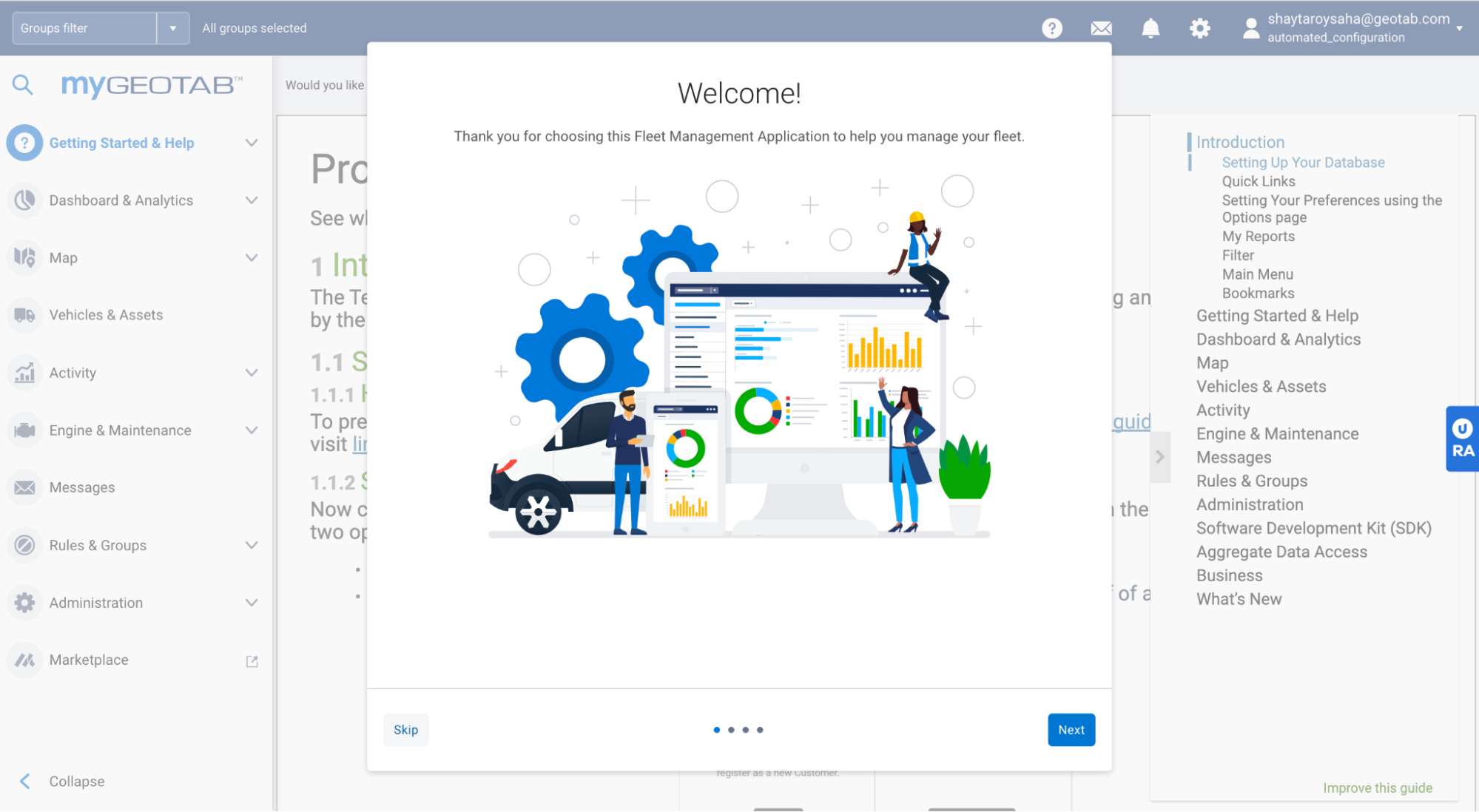
What's new: Personalized onboarding
When a new user logs in for the first time, they are now greeted with a setup guide that asks them a series of questions.
Based on their answers, our system intelligently sets their default landing page and launches a personalized Quick Start Guide with step-by-step tutorials and resources tailored to their role.
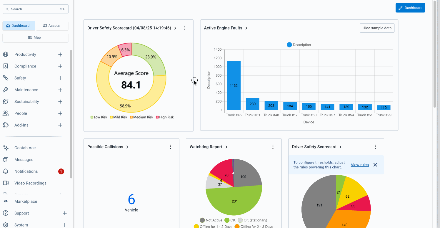
What's new: Upgraded Dashboard experience
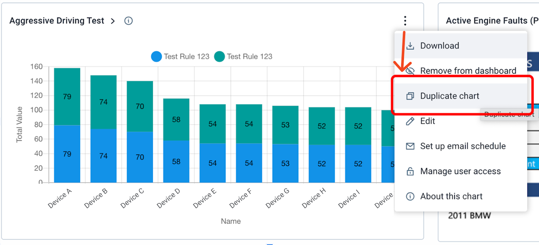
- Pre-loaded charts: Dashboards are now pre-loaded with meaningful, interactive charts relevant to the user's role, providing instant visibility of key metrics.
- Chart management from your Dashboard: The new Dashboard menu allows you to discover and add other interactive, categorized charts to your dashboard.
- Duplicate and edit charts: Any chart can be easily duplicated or edited using its options menu. This allows you to create new, customized versions of a chart to monitor specific data, such as tracking idling metrics across different regional groups.
Why it matters
This update is designed to significantly reduce setup time and flatten the learning curve for new users. By tailoring the initial experience, users are immediately directed to the features that are most relevant to their responsibilities, eliminating the confusion of initial setup and helping users start making data driven decisions from their very first session
Availability
These updates are currently available to any user on a Database created after January 2024. All other users will be migrated to this experience starting August 20, 2025.
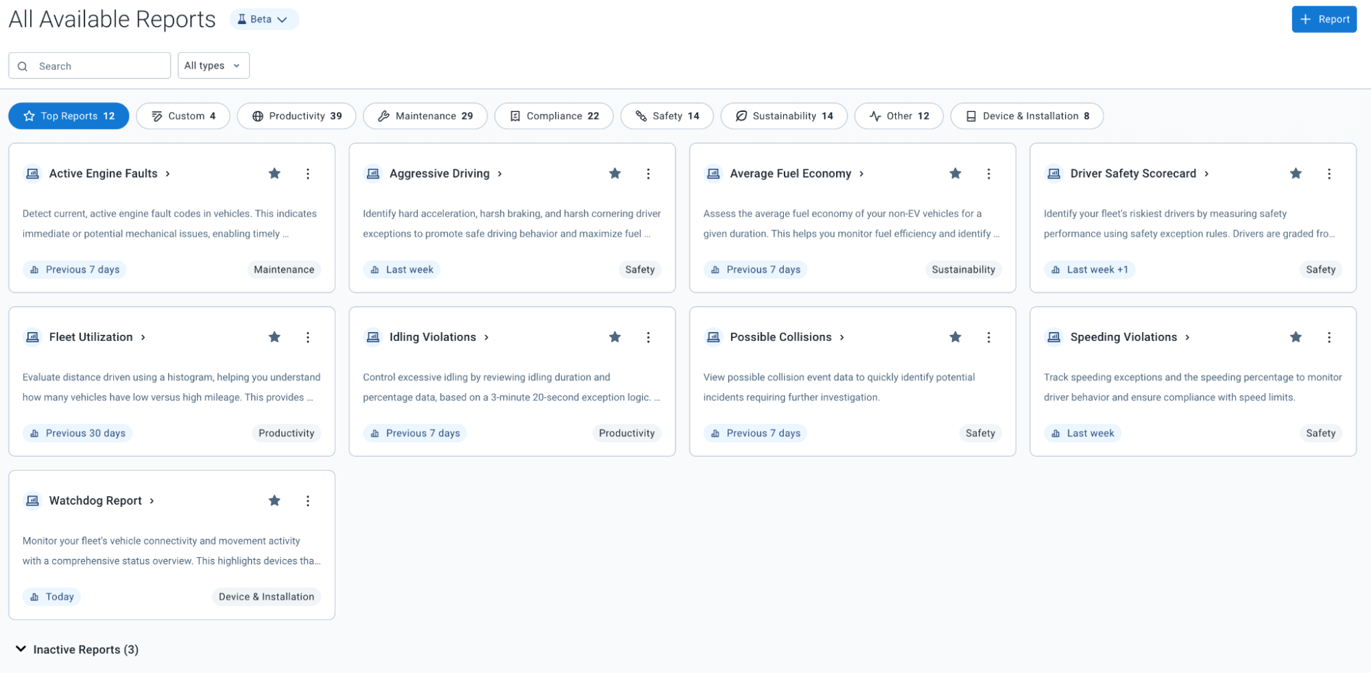
New Report Setup Beta: All Available Reports
The Report Setup page is getting a brand new look and feel, and has been rebranded as the All Available Reports page (Beta). This update aims to reduce the overwhelming experience of sifting through numerous reports to find what you need, and introduces key changes to improve the overall efficiency of the Reports feature.
What’s new?
The new redesign for the page introduces several improvements:
- Improved navigation with smart categories: Reports are now organized into intuitive categories, such as Productivity and Safety, that align with our pillars to allow for quicker filtering.
- Clear report descriptions and search: We now provide descriptions of the data included in each report for better visibility and search
- Highlighted top reports: The top 10 most valuable reports are now highlighted for new customers. Existing users can also favorite reports to create a personalized Top Reports section.
Enhanced custom report management: Custom reports are now prominently displayed for existing users, with the added ability to include your own descriptions for better organization.
Availability
To enable this feature, navigate to Account > Options > Beta Features and toggle the New Report Setup page option to On.
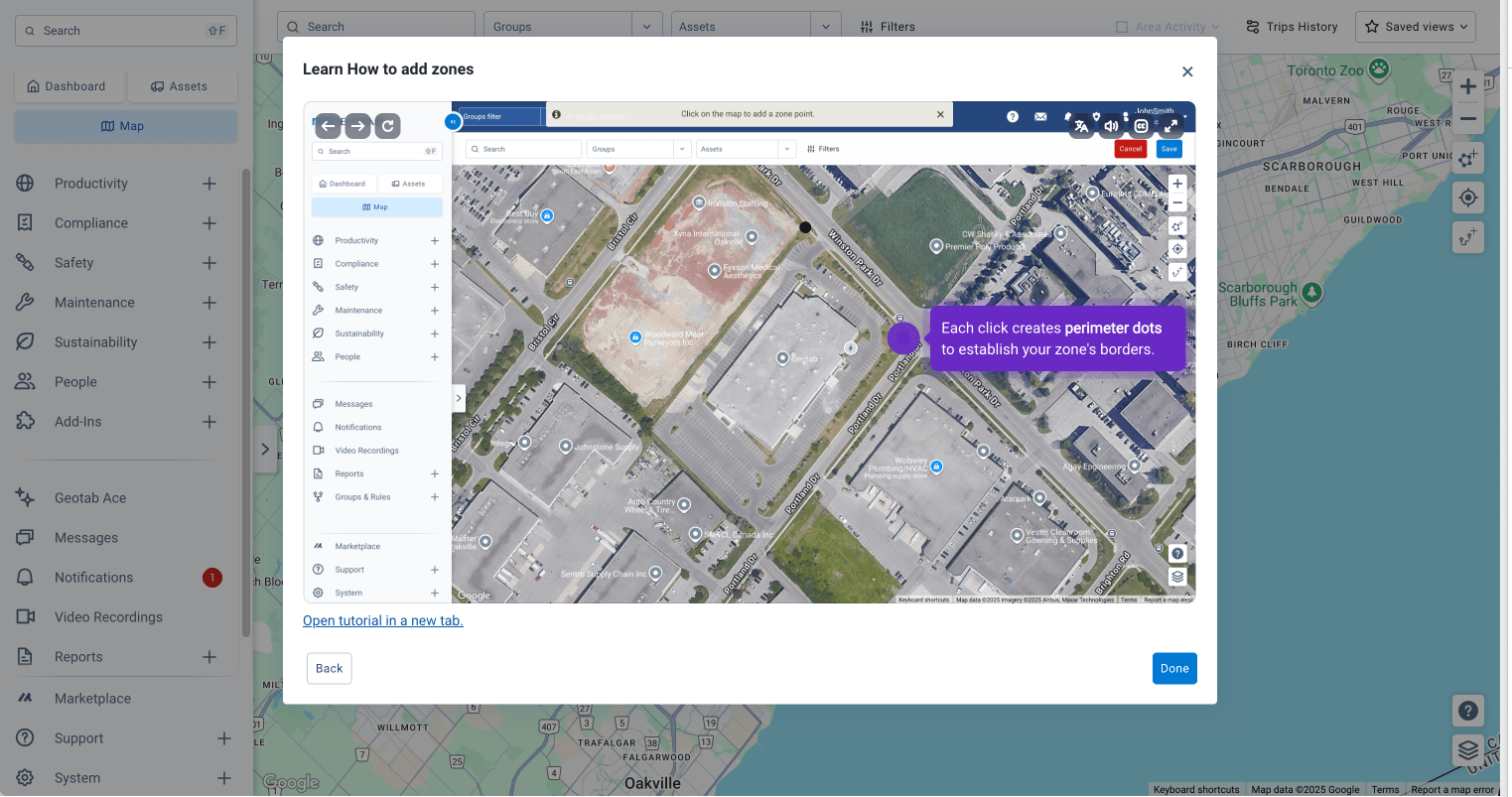
Area activity is now a part of Trips History (Beta)
Many of you already rely on the Area activity feature on the Map to find vehicle activity by location. As we continue to improve our platform, we’re excited to announce that we have integrated this essential feature with the new Trips History page (Beta).
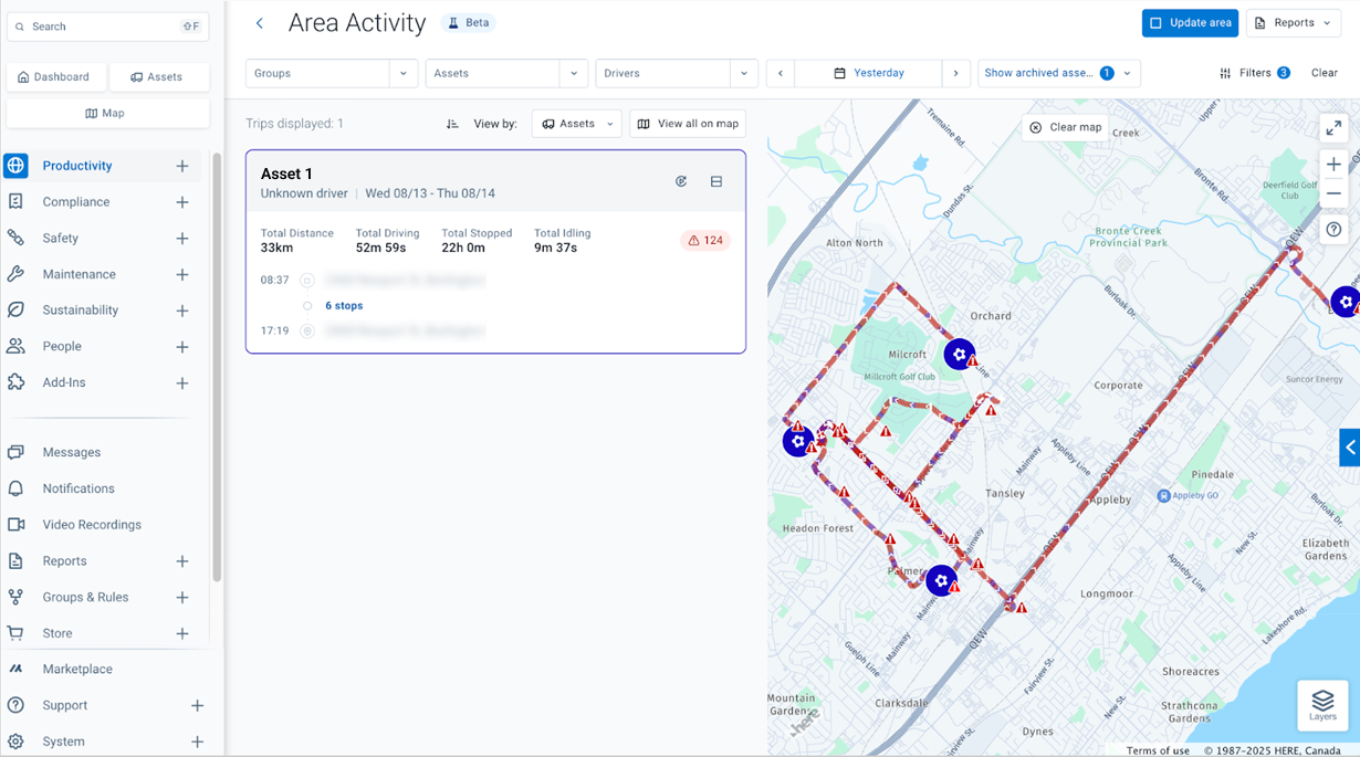
What's new?
You can now filter trip data by a specific, self-defined geographical area without ever leaving the Trips History (Beta) page. This means you can add a location-based filter on top of your other searches, like date ranges or specific vehicles, all in one place.
To use it, navigate to the Trips History page, zoom in on an area on the map, and select Area activity. You can also update your selected area at any time by selecting Update area.

Availability
These updates are being gradually rolled out to Beta users beginning mid-August. To enable the Trips History (Beta), navigate to Account > Options > Beta Features and toggle the Trips History option to On.
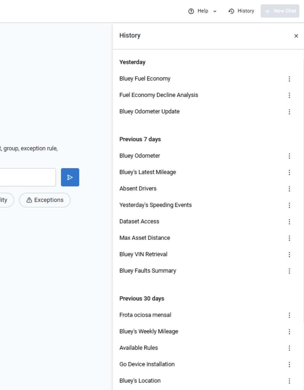
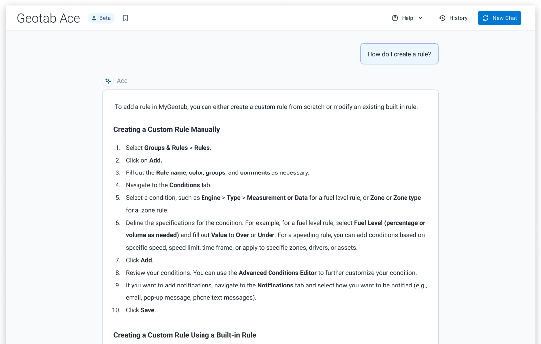
Geotab Ace (Beta) is now smarter and more accessible
This month, we've rolled out a couple of powerful enhancements to our AI assistant, Geotab Ace (Beta). We’ve focused on giving Ace a better memory and expanding its global reach.
View or continue past conversations with Ace
This new panel keeps a running log of your previous chats, allowing you to revisit key findings or pick up where you left off in a previous conversation.
Expanded global access
We've launched Ace in Brazil, Australia, and Asia, empowering international teams with the same powerful AI tools for standardized global operations.
Availability
These updates are available immediately to all users globally. To enable Geotab Ace (Beta), navigate to Account > Options > Beta Features and toggle the Geotab Ace option to On.
Coming soon: Pull answers directly from our Knowledge Base
Pulling answers directly from our Knowledge Base is right around the corner. Ace will soon be integrated with the Knowledge base, giving you immediate support without interrupting your workflow.
Improvements to the MyGeotab Video experience
With the launch of our native GO Focus camera, our commitment to creating a seamless video experience is stronger than ever. This month we’ve released several key updates focused on improving clarity, streamlining workflows, and making video management more intuitive.
What’s new?
We’ve already rolled out several quality-of-life improvements designed to save you time and provide greater clarity.
- Simplified camera management: You can now add a new camera directly from the Asset details view, streamlining the setup process and getting your vehicles equipped and on the road faster.
- More efficient video retrieval: When making a custom video request from the Trips History page, you can now select shorter 10 or 20-second clips. This update helps reduce cellular data consumption and speeds up the retrieval process for quick check-ins.
- Improved user interface clarity: The Video recordings option is now hidden from the main menu for users who do not have "View video" permissions. We’ve also updated the camera lens selector for the GO Focus camera to make switching between views more intuitive.
- Direct video access in notifications: The email template for video events has been updated to include a direct link to the footage, allowing you to review critical events straight from your inbox.
- Smarter AI Clarification: For partners using SmarterAI cameras, we’ve added a note in the Rules settings to clarify that video clip length is determined automatically by the AI, so manual duration settings won't apply.
Coming soon
Towards the beginning of September, you will notice updates to the naming conventions for our video features in MyGeotab. This initiative will standardize language around the core terms "video" and "camera" to provide greater clarity between the footage itself and the hardware that captures it. This change will create a more consistent and user-friendly experience as you navigate the platform.
Notice: Deprecating the Device Installation Wizard (DIW) tool
We are targeting October 15, 2025, to officially retire the legacy Device Installation Wizard (DIW) tool.
All of its features for validating IOX-COLD and IOX-UREADER installations have been fully integrated into our comprehensive MyInstall platform. Going forward, installers will be required to use MyInstall for these validations.
✱ NOTE: Access to MyInstall requires a secure MyAdmin login. For installers a partner installer account can be created following MyInstall User Guide [PUB].
Why it matters
This transition is a key step in providing a more powerful and streamlined workflow for our installation partners and offers several significant advantages:
- A unified experience: By moving these features into MyInstall, we reduce the need to switch between different applications.
- Enhanced security: Standardizing on the MyInstall platform, which requires a MyAdmin login, adds a layer of security and accountability to the installation and validation process.
What you need to do
We encourage all partners and installers to begin using MyInstall for their IOX validations to ensure a smooth transition before the October 15th retirement of the DIW tool.
Email subscriptions for Known Issues
Staying on top of issues with Geotab products and services is key to managing your operations effectively. To help you do just that, we’re making it easier to get the latest information directly from our Known Issues page.
What’s new?
We introduced email subscriptions for the Known Issues page. Opt-in to receive automatic email updates when a Priority 3 or 4 issue is added, updated, or resolved. This allows you to stay current without having to manually check the website for changes.
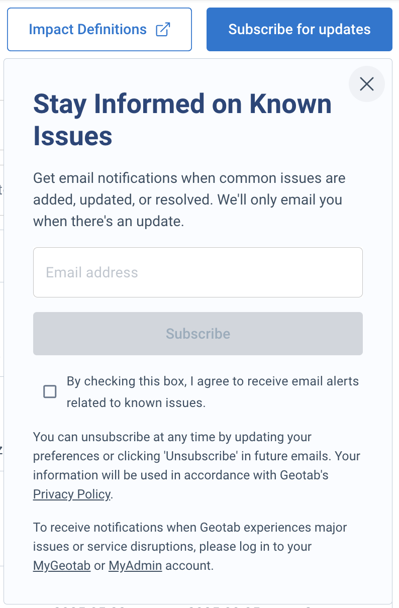
✱ NOTE: Major issues and service disruptions will continue to be communicated using existing methods.
- Customers can update their support contacts from within MyGeotab communications settings.
- Partners can update their communications preferences in MyAdmin.
Why it matters
This feature helps you receive important, non-critical updates, saving you time and helping to keep you in the loop. The key benefits include:
- Time-saving: Updates arrive directly in your inbox, so you no longer need to remember to visit a specific page and scan for new information.
- Timely awareness: You are immediately notified of new or updated issues, ensuring you are always operating with the most current information for troubleshooting or workarounds.
Availability
Anyone can navigate to the Known Issues page and Subscribe for updates.
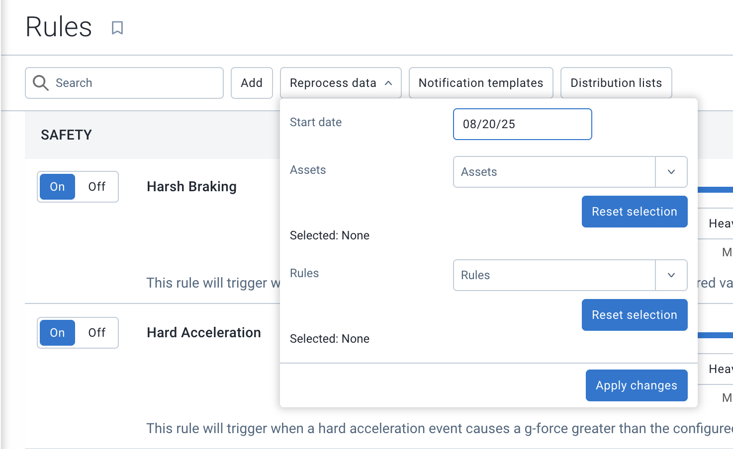
Updates to Data reprocessing
To ensure high performance and stability for all our users, we're updating the self-serve data reprocessing feature. This feature allows you to apply a new or updated rule to your historical data, recalculating all exceptions from a new start date you specify.
Effective September 2025, the maximum look back period for this feature will be updated from 13 months to 6 months. This change applies to reprocessing jobs started through both the user interface and the API. It addresses an issue where extremely large, 13-month reprocessing jobs were impacting platform performance, and ensures a faster, more reliable experience for everyone.
Why it matters
This adjustment is a data-driven decision designed to ensure a faster, more reliable platform for everyone.
- A faster platform for all: This change prevents a single large job from slowing down core functions like maps, reports, and alerts for everyone. It ensures the daily tools you rely on remain fast and responsive.
- Aligning with actual use: Our data shows that over 99% of all reprocessing requests are for data within the last six months. This update aligns the feature's limits with how our customers overwhelmingly use it.
- A more reliable process: For the vast majority of reprocessing jobs, this new guardrail will lead to a faster, more dependable, and successful process, improving the experience for the user running the job.
What if I need to reprocess older data?
While the self-serve option will be limited to six months, we still have a path to support these requests. For critical, well-defined needs to reprocess older data, please contact your Partner or our Support team. These requests will be handled on a case-by-case basis through a support-assisted process.
Release Notes
MyGeotab/Geotab Drive Release Notes
To learn more about all the latest improvements and fixes we’ve deployed as well as any SDK/Add-in updates, read through our Release Notes webpage.
Firmware Release Notes
To stay up to date with our latest firmware releases, read through our Firmware Release Notes.
Got feedback?
If you would like to submit feedback regarding new features, you can do so at any time through the Feedback Hub or your Partner.
Sign up for Geotab news
Stay up to date on what’s new and subscribe to the Geotab newsletter to get these update posts emailed to you.
Subscribe to get industry tips and insights
The MyGeotab and Technical Writing Teams write about MyGeotab updates for Geotab.
Table of Contents
- New User In-App Onboarding and Dashboard updates
- New Report Setup Beta: All Available Reports
- Area activity is now a part of Trips History (Beta)
- Geotab Ace (Beta) is now smarter and more accessible
- Improvements to the MyGeotab Video experience
- Notice: Deprecating the Device Installation Wizard (DIW) tool
- Email subscriptions for Known Issues
- Updates to Data reprocessing
- Release Notes
- Got feedback?
- Sign up for Geotab news