What’s new in MyGeotab — May 2025
Welcome to our latest summary of updates to MyGeotab.
May 26, 2025

Geotab Camera Add-In deprecation
The Camera Add-In is being deprecated in June 2025 as these functionalities are now integrated directly into MyGeotab. As part of this change, camera and video users are reminded to ensure that their security clearances have been updated appropriately to use the new integrated features.
Timeline for the transition
The new native video features were announced in February as an upcoming change, and users were advised that they needed to update user security clearances by mid-May 2025 to facilitate the transition to the new features.
As part of this process, the Camera Add-In will be permanently deprecated in June 2025. The Cameras & Video submenu will be removed from the Safety menu in the two weeks following June 2, 2025. When the Add-In is deprecated at the end of June, users will no longer be able to access their recordings through the Add-In and will need to use the native video features in MyGeotab.
Required actions
If you have not already done so, you will need to:
- Update your security clearances. If you have not updated your clearances, MyGeotab will display a popup notification when you access the new integrated video features.
- Update your bookmarks. Your old bookmarks will no longer work when the Add-In is deprecated. Update them to direct to the new Video Recordings and Camera pages in MyGeotab.
Improvements to Restricted Data Mode (Beta) trip calculations
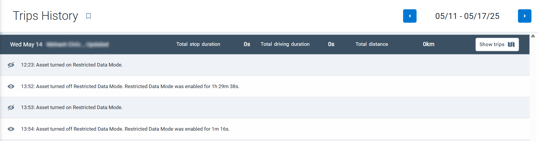
We’ve updated MyGeotab’s trip calculations to give you a better experience using Restricted Data Mode! You can now view individual trip stop and start times for assets both in and out of Restricted Data Mode.
✱ NOTE: Restricted Data Mode is currently available as Beta feature in MyGeotab. For more information on enabling and using Beta features, refer to the Product Guide.
What’s changed?
Previously, when an asset was in Restricted Data Mode, all driving activity during that period was recorded as a single continuous trip, regardless of stops or driver changes. This made it difficult to get insight into asset metrics governed by non-restricted data.
With this new update, the logic for creating individual trips has been refined. Now, even in Restricted Data Mode, individual trip start and stop times will be determined by non-restricted data, such as ignition activity. This means you'll see separate, distinct trips as opposed to a single, lengthy one.
Key benefits for users
This change directly addresses a key pain point for customers using Restricted Data Mode. It ensures that the software's behavior more closely aligns with its default operation when GPS data is fully available.
More importantly, it allows you to gain access to more useful metrics per trip. You'll be able to see detailed information like fuel usage and trip summary data for each individual segment, even when GPS data is restricted. Additionally, other system functionalities that don't rely on GPS, such as productivity metrics, fuel usage, and engine fault reporting, will continue to work as expected.
✱ NOTE: When your database is updated to include this feature, any ongoing Restricted Data Mode trips will immediately end and a new trip will be started. Any trips recorded in Restricted Data Mode from that point forward will follow the default trips logic.
Improved Public Works with new IOX-WRKS Firmware
We’ve released the new IOX-WRKS firmware v28, bringing significant improvements to controller reporting, data accuracy, and overall system performance. This update is designed to help you manage your resources more efficiently and enhance operational control.
What's new in Firmware v28?
This firmware release addresses several key challenges faced by public works users, including faster reporting times, enhanced data accuracy, reduced diagnostic messaging, and expanded controller support. Key updates include:
- Marwis improvements: Parsing issues from Marwis devices for parameters such as Road Condition, Freezing Temperature, and Humidity at Road Temperature have been corrected.
- DICKEY-john Control Point controller updates: An issue that caused DICKEY-john controllers to display highly variable and inaccurate readings for both Total Solid Material and Total Prewet Material has been resolved.
For more details on the improvements included in Firmware v28, see the Release Note.
Availability
This new IOX-WRKS firmware v28 is available now in the Early Access Channel.
Enhancements to Advanced Routing & Optimization
We’ve made some updates to the Advanced Routing & Optimization solution, focusing on providing greater flexibility and enhanced planning capabilities.
New Administration features
We’ve added two new Administration enhancements:
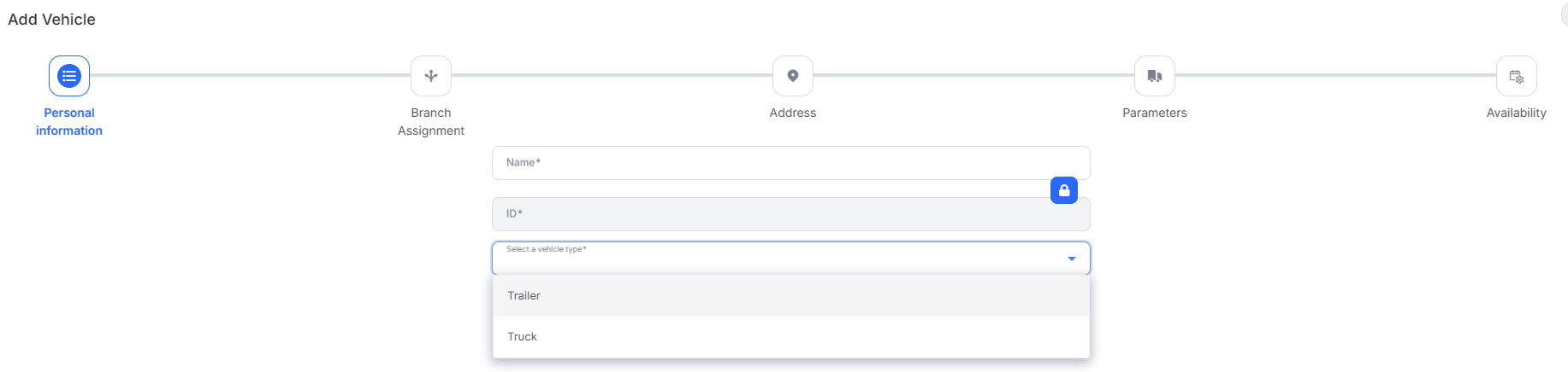
- Resource Profiles: Administrators can now create customizable profiles containing various routing parameters. These profiles allow for specifying rulesets related to distance, cost, and time, and can be assigned to individual resources, allowing for more tailored route optimization.
- Resource Types: Resources can be configured as either a Driver or a Vehicle (Truck or Trailer). The Vehicle type includes parameters for dimensions and volume, and enables consideration of capacity when planning routes, a feature slated for future implementation.
Route, Dispatch, and Mobile Updates
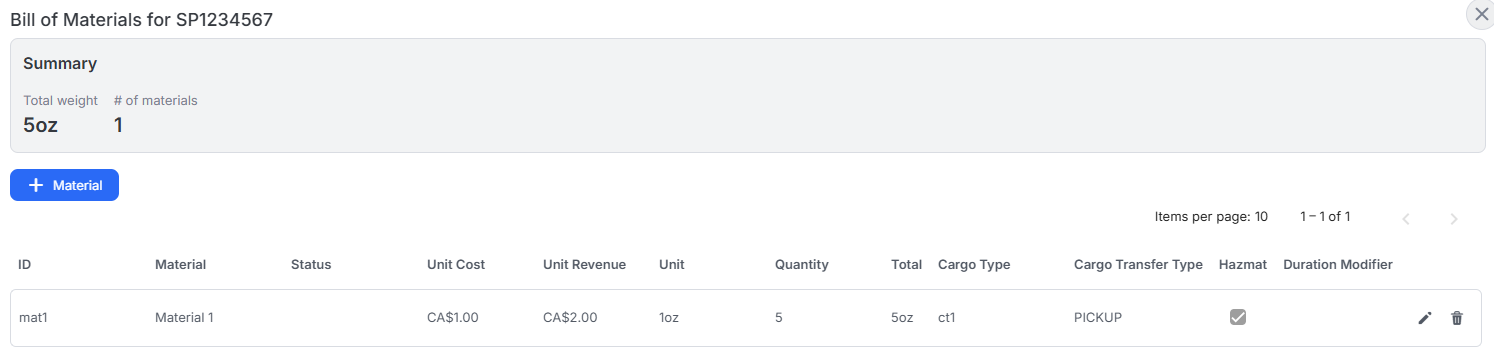
We’ve added a new Bill of Materials feature. The Bill of Materials is a dataset associated with a specific appointment, defining the included material parameters. While this function is intended to be part of the future vehicle capacity planning feature, users can add and view bills of materials in several ways currently:
- In Route, users can upload a CSV file (using a downloadable template) to add a bill of materials to appointments.
- In Route and Dispatch, users can view and edit individual appointment bills of materials in the Schedule Board.
- In Dispatch, users can add a bill of materials to a new same-day appointment upon creation.
- In Mobile, users can view individual appointment bills of materials.
Improved accuracy with Snap2Road 2.0 feature
We’ve enhanced our GPS data mapping capabilities with the new Snap2Road 2.0 algorithm. This update addresses limitations in the previous Snap2Road functionality.
What is Snap2Road 2.0?
The new Snap2Road 2.0 algorithm is an improved version of the original Snap2Road algorithm. It’s designed to address issues with inaccurate mapping of GPS data to road segments, a problem that contributes to incorrect speeding events in MyGeotab.
The limitations of the original Snap2Road algorithm were exposed by this issue, which prompted the creation of the new Snap2Road 2.0 enhancements. The new algorithm provides more precise mapping of GPS data to roads and has been tested with more than 1000 customers to demonstrate its enhanced accuracy.
Key benefits for users
The enhancements provided by Snap2Road 2.0 allow for improved speeding event detection, a reduction in false positives, and the capture of speeding events that may have been missed before, giving you greater insight into your fleet’s driving habits.
Availability
Snap2Road 2.0 will be rolled out to all customer databases in the coming weeks, with some exceptions.
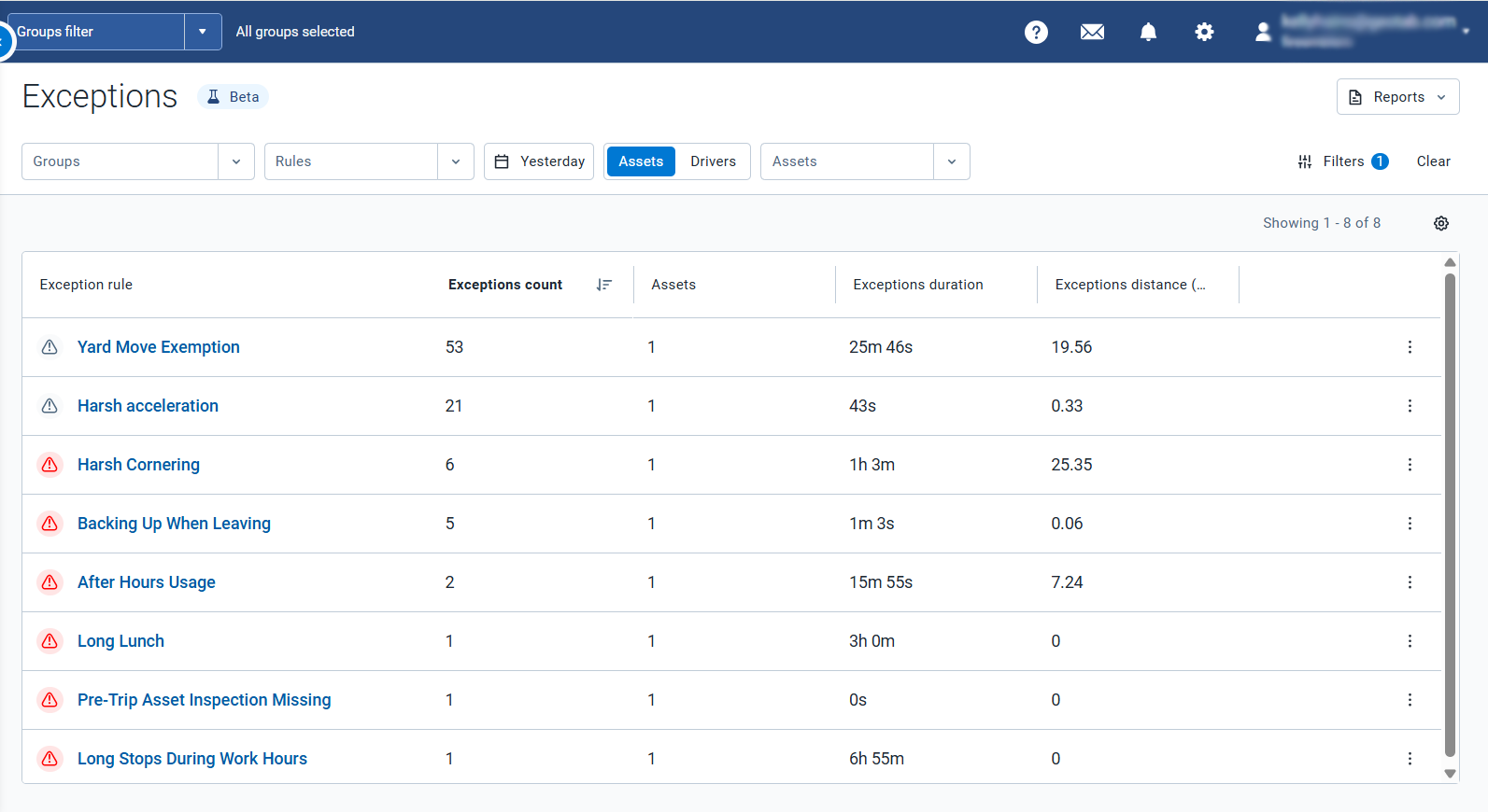
New Exceptions page redesign in MyGeotab (Beta)
We’re excited to introduce a redesigned Exceptions page in MyGeotab! This update provides a more streamlined and efficient way to explore and manage your fleet's exceptions.
✱ NOTE: The new Exceptions page is currently available as Beta feature in MyGeotab. For more information on enabling and using Beta features, refer to the Product Guide.
What’s New?
The new Exceptions page (Beta) includes a redesigned interface with smoother transitions, making it easier than ever to navigate from summarized views to specific event details. These improvements significantly reduce loading times, especially for users managing a high volume of exceptions. Furthermore, to improve clarity and consistency, all event timestamps are now displayed in the corresponding device or driver’s local time zone.
Ultimately, this update offers a more improved and efficient experience for all users.
You can learn more about the redesign in the Exceptions Page and Report Enhancements guide.
Risk Analytics now available in the Drive App
We’re excited to announce that Risk Analytics, a powerful tool previously only available in MyGeotab, is now accessible to drivers through the Geotab Drive App! This update empowers drivers with unprecedented access to safety insights.
 | 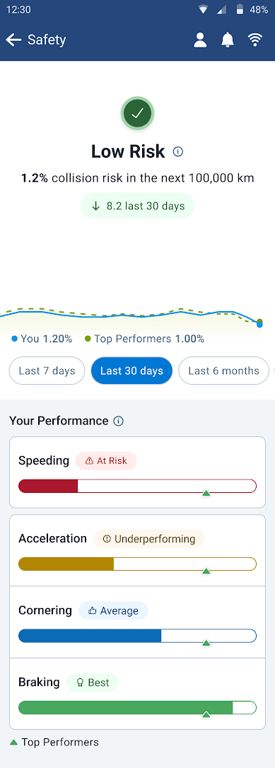 |
What is Risk Analytics?
Risk Analytics provides data-driven insights into collision risk. It calculates the probability of a collision over the next 100,000 km or miles for both the overall fleet and individual vehicles. These analytics are based on standardized exceptions developed by Geotab’s DNA team, analyzing data from over 4.7 million assets and tailored to specific asset types.
Key benefits for users
By providing drivers with direct access to Risk Analytics, Geotab aims to:
- Promote improved driver and roadway safety by proactively identifying potential issues based on past driving behavior.
- Eliminate the need for drivers to use multiple tools and manage multiple passwords to understand their safety performance, reducing cognitive load.
- Improve communication between fleet managers and drivers by providing a shared understanding of safety data.
Availability
Risk Analytics in the Drive App is available now. While the feature is enabled by default for all databases, driver safety profiles are initially turned off and must be activated using the View Driver Safety Insights on the Drive App sub clearance. For more information on how to use sub clearances, see Creating custom security sub clearances.
Once the feature is activated, Drivers will see a new Safety tile in the Drive App, providing them with access to Risk Analytics and related safety information.
Subscribe to get industry tips and insights
The MyGeotab and Technical Writing Teams write about MyGeotab updates for Geotab.
Table of Contents
- Geotab Camera Add-In deprecation
- Improvements to Restricted Data Mode (Beta) trip calculations
- Improved Public Works with new IOX-WRKS Firmware
- Enhancements to Advanced Routing & Optimization
- Improved accuracy with Snap2Road 2.0 feature
- New Exceptions page redesign in MyGeotab (Beta)
- Risk Analytics now available in the Drive App