What’s new in MyGeotab — Version 2004
Welcome to our latest summary of updates in MyGeotab.
Dec 27, 2023

Geotab Users: To verify your version: go to MyGeotab > Administration > About, and check the build number, (e.g. 5.7.2004.xxx release).
Resellers: Review this post for important changes affecting your customers and note any recommendations.
Sign up for Geotab news
Stay up to date on what’s new. Please subscribe to the Geotab newsletter to get these update posts emailed to you.
✱ NOTE: The images shown here are for illustration purposes only, and may appear different in the software as we approach the final release.
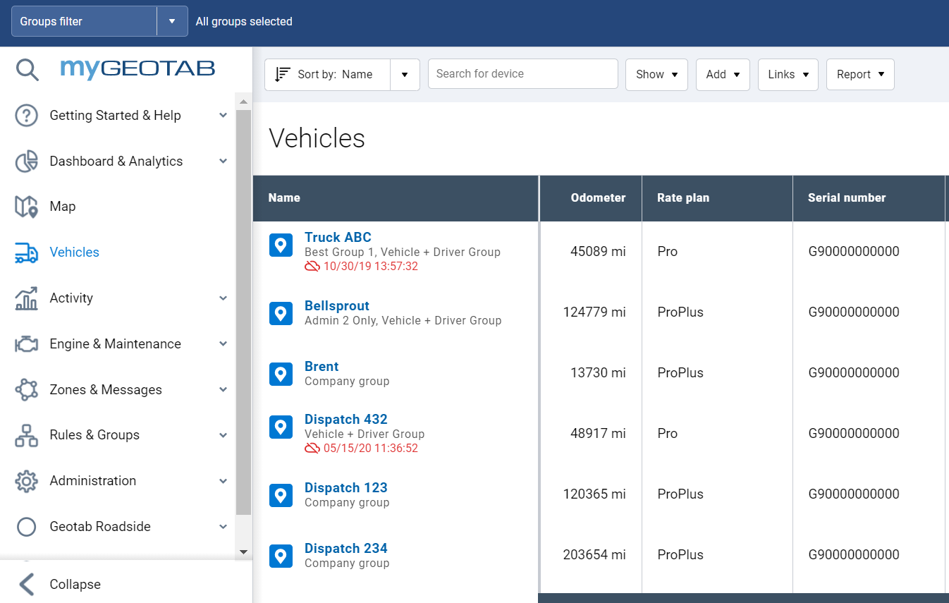
New MyGeotab design
New and improved MyGeotab redesign (Feature Preview)
We are proud to announce the launch of the new and improved design of MyGeotab, currently in Feature Preview! Using industry-best UX practices, our product design team has collaborated with our product and development teams to redesign and update the overall look of MyGeotab.
The new and improved design focuses on drawing the eye to the important areas of the page using simple and clean colors and fonts. The navigation icons have been redesigned to focus on the meaning behind each symbol, and use color to clearly indicate the currently selected item. Buttons and components have been updated to be more intuitive and to follow modern patterns.
We have designed these improvements to be minimally disruptive. The new design is ready to be used immediately with no re-training required.
You can see these improvements on the following pages:
- Dashboard
- Main vehicles page
- Users
- Zones
- Speed profile
- Trailers
- Groups
- System Settings
- Rules and rules edit
- DVIR pages
- Customer visits
- Map and Trips History
- Routes
- Help Guide
- Custom reports
- Risk management
- Engine measurements and faults
Please let us know what you think of the new changes by filling out this feedback survey.
IMPORTANT: Add-In developers, please be aware that in the 2004 release, your Add-In icons will not be displayed in MyGeotab. For the 2101 release, we will be adding functionality to allow developers to upload an icon that conforms to our design specification. Please stay tuned to our Blog for more information on Add-In icons.
Reports
New optional columns for the Trips Summary report
Two new optional column headers have been added to the custom Trips Summary report:
- TripSummaryDaysDriven: Based on the device’s timezone, this indicates how many days had at least one trip occur over the chosen time period.
- TripSummaryOdometerAtEnd: Indicates the ending odometer of the vehicle at the end of the chosen time period.
These columns headers can be added to a Trip Summary report to get more information about your fleet’s vehicle usage. Combining this information with additional data points can tell you which vehicles are being utilized on a regular basis, and which vehicles are under-utilized. In addition, odometer data can be combined with the TripSummaryDistance to indicate the starting odometer for each vehicle for reporting purposes.
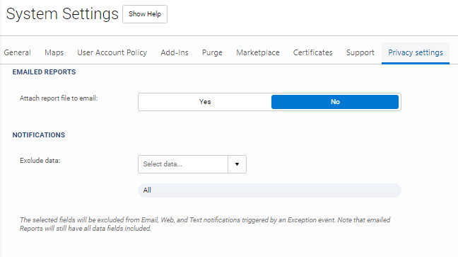
Choose whether you want to receive reports as email attachments or not (Feature Preview)
For customers who have security as top of mind, we have a new setting available. In System Settings > Privacy Settings, there is now an option that allows you to choose whether or not you want to receive your reports as email attachments.
Today, you can receive your reports by email in two ways:
- Scheduled email reports
- Notification emails, when you choose to receive an exceptions report
If you choose not to receive reports as email attachments, when the report is ready, you will receive an email with instructions on where to go in MyGeotab to download it.
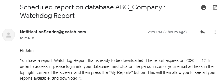
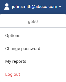
In your database, you can now navigate to the top right corner to open the My reports page.
Map
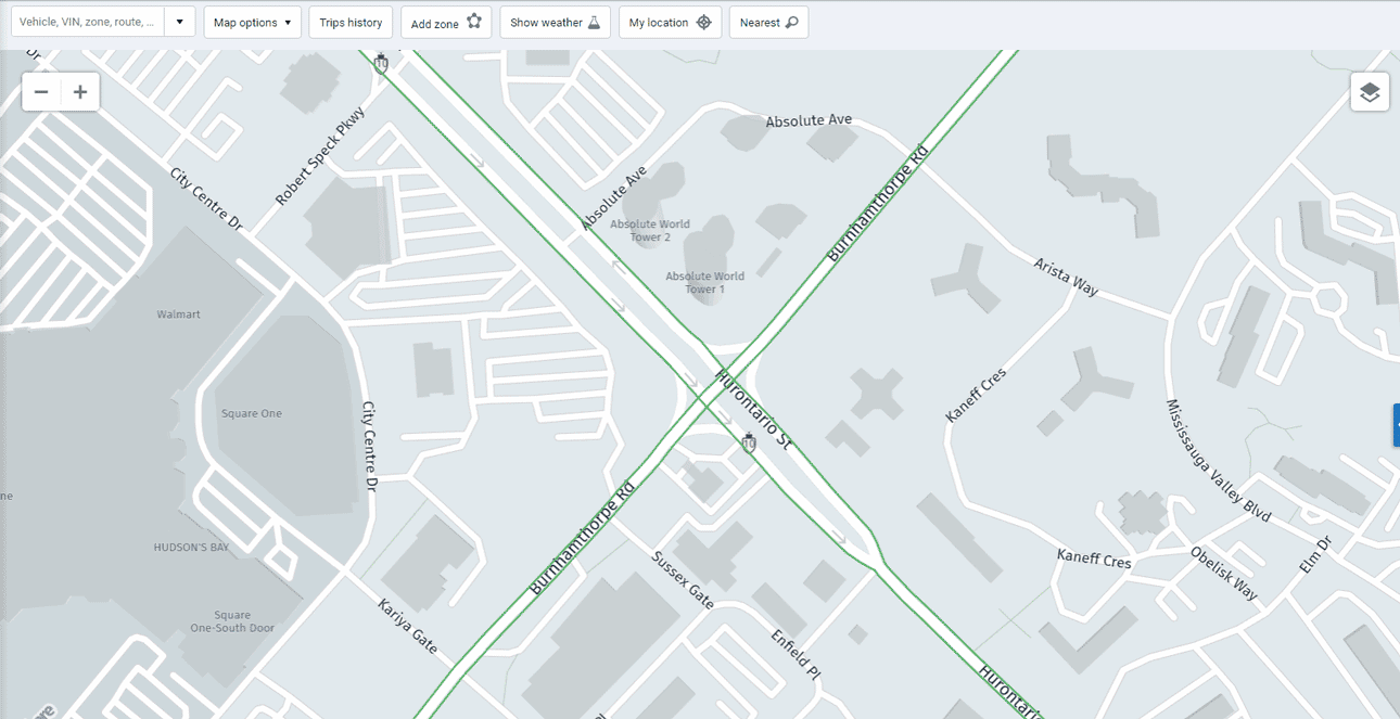
Area activity search (Feature Preview)
Have you ever needed to investigate what happened in a particular area over a specific period of time? Perhaps you got a call from someone saying one of your drivers did not pick up a load last Friday at 4pm? Now you can easily search on the map when this happens.
Simply zoom in to the area, click the particular location, select Area Activity, and enter your date and time range. MyGeotab will take you to the Trips History page, where you will see the exact vehicles that were in the area and trips that happened during that time.
Please note that you may need to adjust your zoom level before the Area Activity feature becomes available.
MyGeotab will remember your Show Traffic settings next time you log in
Many users leverage the Show Traffic setting on the live map to better manage their fleet. For ease of use, MyGeotab will now remember if you have turned this setting on the next time you log in.
Driver Identification terminology changes
At Geotab, we believe in diversity and inclusion. With this in mind, we have changed the words “whitelist” and “blacklist” to “allow” and “block”. We believe by removing racially suggestive words from our terminology, we set a better example for you, and for ourselves.
Vehicles without serial numbers
Add vehicles into the system without a serial number. Some of the use cases for this feature are:
- You know the vehicle in which you plan on installing a telematics device, but don’t have the device yet. You can now add the vehicle into the system and set it up with the appropriate name, groups, license plate, and other information, and add the serial number afterwards.
- You have assets that you want to do inspections against or set maintenance reminders for, but may not have any immediate plans to purchase a telematics device.
If you are interested in testing this feature, please contact mygproduct@geotab.com. Feature is not available by default.
Please note that functionality is very limited without a telematics device.
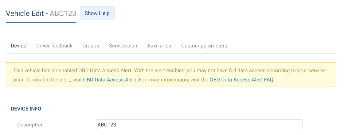
OBD alert
OBD alert messages
A very small number of vehicle models sound an alert if any On-Board Diagnostic (OBD) third-party device (for example, the GO device) makes a data request via the OBD port while the vehicle is locked and the ignition is off. In order to prevent sudden alerts that may surprise you, the GO device automatically disables this alert by default in order to provide full data access according to its service plan, without risk of the alert sounding.
However, we want to make sure you are aware this setting does exist, and provide you the option to re-enable the OBD alert. Doing so will significantly limit the data the GO device records.
To learn more see the OBD Port Audible Alert FAQ.
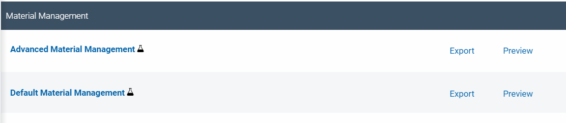
Material management reports
To better support our public works customers we have released new material management reports (currently in Feature Preview).
New rules (Feature Preview)
We added six rules to the new Expandability section on the Rules page to support the new Material Management report. These six rules must be set to On to successfully run the report.
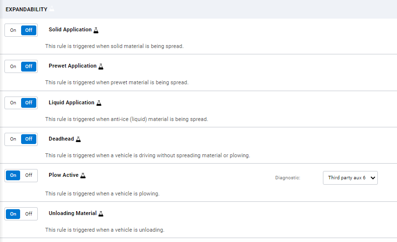
The plow input for Deadhead and Plow Active rules are set to Third party aux 5 by default. Users can change the input depending on the installation but the input number for both rules must be the same.
Material Management reports (Feature Preview)
We added two new reports powered by the Rules mentioned above. These new reports support material management for your fleet by allowing you to view your material usage on a per-trip basis.
Users
Driver Identification terminology changes
At Geotab, we believe in diversity and inclusion. With this in mind, we have changed the words “whitelist” and “blacklist” to “allow” and “disallow”. We believe by removing racially suggestive words from our terminology, we set a better example for you, and for ourselves.
Added ability to filter by Rulesets and Authentication types (Feature Preview)
You can now filter the Users page by HOS Rulesets and Authentication type.
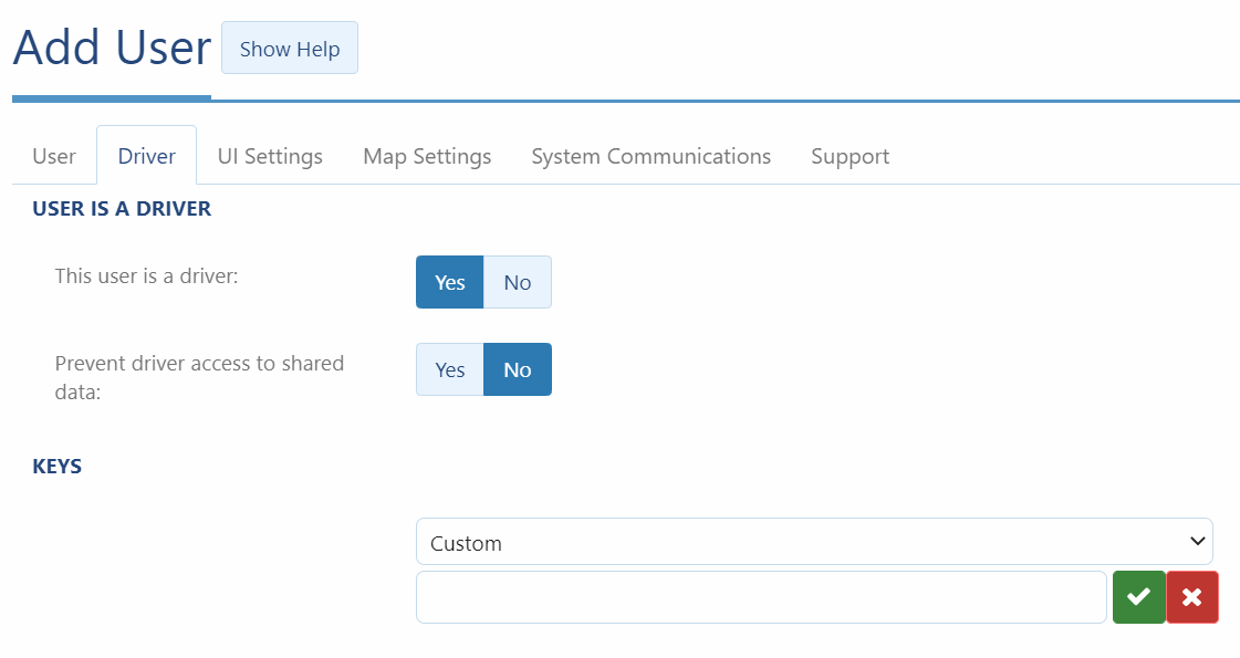
Custom keys for drivers
Third-party keys for drivers can now be added as custom keys in MyGeotab. Simply open the Edit User page and add the key under the Driver tab, or add the key under the same tab when adding a new user.
“Select all” functionality now checks for applied filters
Previously, when using the “select all” functionality on relevant pages, such as Vehicles and Users, we were not checking for applied filters. After receiving feedback, we have now decided to apply any filters chosen on the page when performing bulk actions such as editing.
Reset password no longer requires you to enter database name
Previously, users had to enter their database name as a part of the reset password process. However, most end users do not remember their database name, so we have removed the database name requirement but implemented a CAPTCHA to prevent misuse.

Duty Status Logs
Page name has changed to HOS Logs
To maintain consistency, we have renamed the “Duty Status Logs” page to “HOS Logs” — found under Activity > HOS Logs. Previously, the MyGeotab UI used the terms interchangeably while referring to the same feature.
Messages
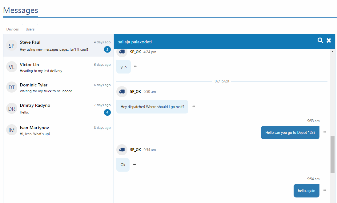
A better way to send messages
As announced in the previous release, the Messages feature has been updated. Stay connected with your drivers using the new consolidated messaging feature. Threaded views provide conversation-style messages with simple-to-use input controls such as adding links and canned replies. Messages can be sent to devices for anyone driving the vehicle to see, or directly to users for private two-way communication. Unread messages display in tab titles for easy detection, or as shortcuts under Notifications on the main title bar. Messages can be searched using date and display filters for accurate and friendly searches.
Direct messages to and from drivers are now available.
Rules
Percentage over speed limit (Feature Preview)
Some regions of the world assess speeding fines based upon a percentage over the speed limit. You can now choose how you want to monitor speeding based on a value or a percentage.

Language
Added language support for Indonesian
We’ve added another language to MyGeotab! The application is now available in Indonesian.
General improvements
- Removed transparency setting on Group edit page.
- Fixed bugs and translation issues.
- Applied consistent decimal point truncation to reports.
- Removed legacy diagnostics from the engine measurements page. Only System and Telematics source diagnostics will be displayed.
- Updated engine measurements page list of default diagnostics based on most popular diagnostics selected by customers.
- Added “unplug” device as an option on the multiple vehicle editing page.
- New notification tokens for EV’s: EV Battery Charge % and EV charging state.
- Time card report will now consistently display the last stop of the day, based on the device’s timezone, and not the user who is running the report’s timezone.
Geotab SDK and Add-In updates
New Media File API
Geotab is happy to announce a new set of APIs related to Media Files. This new API can be used to store images or video clips related to a device or driver.
MediaFile: MediaFile is a new type used to store images or video clips related to a device or driver. More information about media files can be found here.
MediaType: The type of Media.
Status: The status of an uploaded file.
MediaFileSearch: The object used to specify the arguments when searching for MediaFile. This will return the data describing a file, not the actual file.
Tag: A named tag to provide context to an entity.
DownloadMediaFile: Download a file for the given MediaFile. The Content type is determined by the file extension. Range headers are supported.
UploadMediaFile: Upload a file for the corresponding MediaFile using multipart/form-data POST request.
SecurityIdentifier: Added ViewMedia and ManageMedia.
General SDK updates
BinaryDataType
- Added "ThirdPartyData" type to allow flexible length binary data format records to be stored.
Methods
- GetCountOf method now accounts for user scope. It previously did not account for user scope, which was a bug.
ZoneSearch
- "Viewport" is obsolete and no longer officially supported. It is replaced with "SearchArea'' property. This will be better represented by the type "BoundingBox". Providing a bounding box is simpler to use because map libraries provide viewport/map bounds in this way already. Backwards compatibility will be maintained with the "Viewport" property, though no longer documented.
BoundingBox
- Added "BoundingBox" which represents a geographic area defined by the top-left and bottom-right coordinates.
DiagnosticSearch
- Added searching by diagnostic name.
FaultDataSearch
- Added searching by Diagnostic Code, Diagnostic Name, Diagnostic Source Name, Diagnostic Source Id, FaultState and Controller Id.
Generator-addin
- Added groups filter to generator-addin
HOSRuleSet
- Added: America7DaySleeper, America7DayBigSleeper, America8DaySleeper, America8DayBigSleeper, OilTransport7DaySleeper, OilTransport7DayBigSleeper, OilTransport8DaySleeper, OilTransport8DayBigSleeper, America7DayNo34hSleeper, America8DayNo34hSleeper, AmericaNoRestRequirement7DaySleeper, AmericaNoRestRequirement7DayBigSleeper, AmericaNoRestRequirement8DaySleeper, AmericaNoRestRequirement8DayBigSleeper, OilWell7DaySleeper, OilWell7DayBigSleeper, OilWell8DaySleeper, OilWell8DayBigSleeper, OilTransportNoRestRequirement7DaySleeper, OilTransportNoRestRequirement7DayBigSleeper, OilTransportNoRestRequirement8DaySleeper, OilTransportNoRestRequirement8DayBigSleeper, OilWellNoRestRequirement7DaySleeper, OilWellNoRestRequirement7DayBigSleeper, OilWellNoRestRequirement8DaySleeper, OilWellNoRestRequirement8DayBigSleeper, AlaskaProperty7DaySleeper, AlaskaProperty8DaySleeper
Removed BETA attribute on the following objects:
- AnnotationLog
- AnnotationLogSearch
- ApplicationVersionInformation
- DefectRemark
- DefectSeverity
- DutyStatusAvailability
- DutyStatusAvailabilitySearch
- DutyStatusLog
- DutyStatusLogSearch
- DutyStatusLogType
- DutyStatusMalfunctionTypes
- DutyStatusOrigin
- DutyStatusState
- DutyStatusViolation
- DutyStatusViolationSearch
- DutyStatusViolationType
- DVIRDefect
- DVIRDefectSearch
- DVIRLog
- DVIRLogSearch
- DVIRLogType
- DtcClass
- DtcSeverity
- ElectricEnergyEconomyUnit
- ElectricEnergyUnit
- HosRuleSet
- InvalidMyAdminUserException
- RepairStatusType
- ShipmentLog
- ShipmentLogSearch
- TextMessageContentType
- Trailer
- TrailerAttachment
- TrailerAttachmentSearch
- TrailerSearch
- VersionInformation
- GetVersionInformation
- GetFeed:Audit
- GetFeed:Device
- GetFeed:Diagnostic
- GetFeed:DriverChange
- GetFeed:Route
- GetFeed:Rule
- GetFeed:TextMessage
- GetFeed:TrailerAttachment
- GetFeed:Driver
- GetFeed:Zone
Java SDK (Feature Preview)
We work hard to create fast and flexible tools that make sense for your business, and your feedback is an essential part of that process. With this in mind, we are previewing our new Java SDK, and we want you to tell us how we did! So go ahead – test the kit, join our Community Developer Discussions to help us improve our product, and get to know our users.
The Java SDK offers an easy way to integrate MyGeotab into Java software. All communication with Geotab services is accomplished using HTTPS with serialized data in JSON format. The Java library provides Java objects representing MyGeotab entities and automatically handles their JSON serialization and deserialization.
The Java SDK is available as a Maven Dependency Library from the Maven Central Repository and includes documentation with information and usage samples for your new kit.
You can find Java-based API usage samples at https://github.com/Geotab/sdk-java-samples
Samples include:
- Get Logs for a given vehicle between a range of dates.
- Send Text Messages to and from a GO device
- Import Groups includes a console example that is also a Group import tool. The sample enables a one-time import of groups to a database from a CSV file.
- Import Devices includes console example that imports devices from a CSV file.
- Import Users includes a console example that imports users from a CSV file.
- Get Data Feed includes an example for retrieving GPS, StatusData and FaultData as a feed, and for exporting to CSV file.
Supported Methods include:
- Authenticate
- Get
- Add
- Set
- Remove
- GetFeed (LogRecord, StatusData, FaultData, Trip)
- GetCountOf
Supported Objects include:
- Id
- Entity
- EntityWithVersion
- NameEntity
- NameEtityWithVersion
- LoginResult
- Credentials
- Coordinate
- Color
- Controller
- ControllerSearch
- Device (all types)
- DeviceSearch
- Diagnostic
- DiagnosticSearch
- DataDiagnostic
- DiagnosticType
- EngineType
- EngineTypeSearch
- FailureMode
- FailureModeSearch
- FaultData
- FaultDataSearch
- FlashCode
- Group
- GroupSearch
- IoxAddOn
- IoxAddOnSearch
- LogRecord
- LogRecordSearch
- ParameterGroup
- ParameterGroupSearch
- Source
- SourceSearch
- StatusData
- StatusDataSearch
- TextMessage
- TextMessageSearch
- TextMessageContentType
- Trip
- TripSearch
- UnitOfMeasure
- UnitOfMeasureSearch
- User
- Driver
- UserSearch
- WorkTime
- WorkTimeDetail
- WorkTimeHolidayGroupId
- WorkTimeSearch
- DefectSeverity
- DeviceType
- DiagnosticType
- DtcClass
- DtcSeverity
- ElectricEnergyEconomyUnit
- FaultLampState
- FaultResetMode
- FaultState
- FuelEconomyUnit
- GoogleMapStyle
- GoTalkLanguage
- HosOption
- HosRuleSet
- MessageContentType
- OpenStreetMapStyle
- SecurityIdentifier
- SecurityFilter
- ZoneDisplayMode
- MapView
- FeedResult
- DbUnavailableException
- DuplicateException
- GroupRelationViolatedException
- InvalidMyAdminUserException
- InvalidUserException
- OverLimitException
- RegistrationException
- JsonRpcError
- JsonRpcErrorData
Contributors:
Vik Sridhar, Sr. Product Manager; Jamil Wahid, Product Manager; Technical Writing Team; Inshaal Badar, Sr. Content Writer; Sarah Kerr, Sr. EV Product Manager
Subscribe to get industry tips and insights
The MyGeotab and Technical Writing Teams write about MyGeotab updates for Geotab.
Table of Contents
Subscribe to get industry tips and insights
Related posts

The plug-and-play rental fleet: Upgrade your technology without missing a single booking
April 27, 2026
5 minute read

The Evolution of Product Updates: Welcome to Your New Centralized Hub
December 15, 2025
2 minute read