Altitude by Geotab Study Reveals Impact of NYC Congestion Pricing on Commercial Fleets
Vehicles Moving Faster, Fewer Large Trucks and Idling Metrics Unchanged
November 3, 2025
•2 minute read

ATLANTA, GA (July 25, 2025) – Using data from over 16,000 vehicle trips, a new study from Altitude by Geotab provides the first comprehensive look at the New York City congestion pricing (CP) program’s impact on freight movement in Lower Manhattan. The analysis reveals significant changes in commercial traffic flow and the types of vehicles driving through the congestion zone.The analysis shows no substantial change to idling metrics in the congestion zone area.
New York City's highly anticipated CP program rolled out at the start of 2025 with the aim to alleviate gridlock in Lower Manhattan. While initial reports of the program's effectiveness primarily focused on passenger vehicles, Altitude by Geotab’s early data analysis now paints a clear picture of the program’s initial effects on commercial vehicle movement, critical for the city's supply chain and last-mile delivery. The study looked at data from January through May 2024 compared to the same five-month period in 2025 to understand how commercial fleet activity changed after the introduction of congestion pricing.
Key Findings for Commercial Traffic in Congestion Area:
- Truck Traffic is Moving Faster: Between 8 a.m. and 6 p.m., 44% of Lower Manhattan roadways saw faster commercial vehicle travel times (40% unchanged).
- Fewer Large Trucks, More Multi-Purpose Vehicles: A noticeable decrease in the number of larger (medium- and heavy-duty) trucks entering the congestion pricing zone was observed, with a corresponding increase in multi-purpose vehicles.
Idling Behavior Largely Unchanged: Despite improved traffic flow and a shift in vehicle types, analysis has not shown a substantial change in how long vehicles spend idling within the zone.
![map of New York show time to travel]()
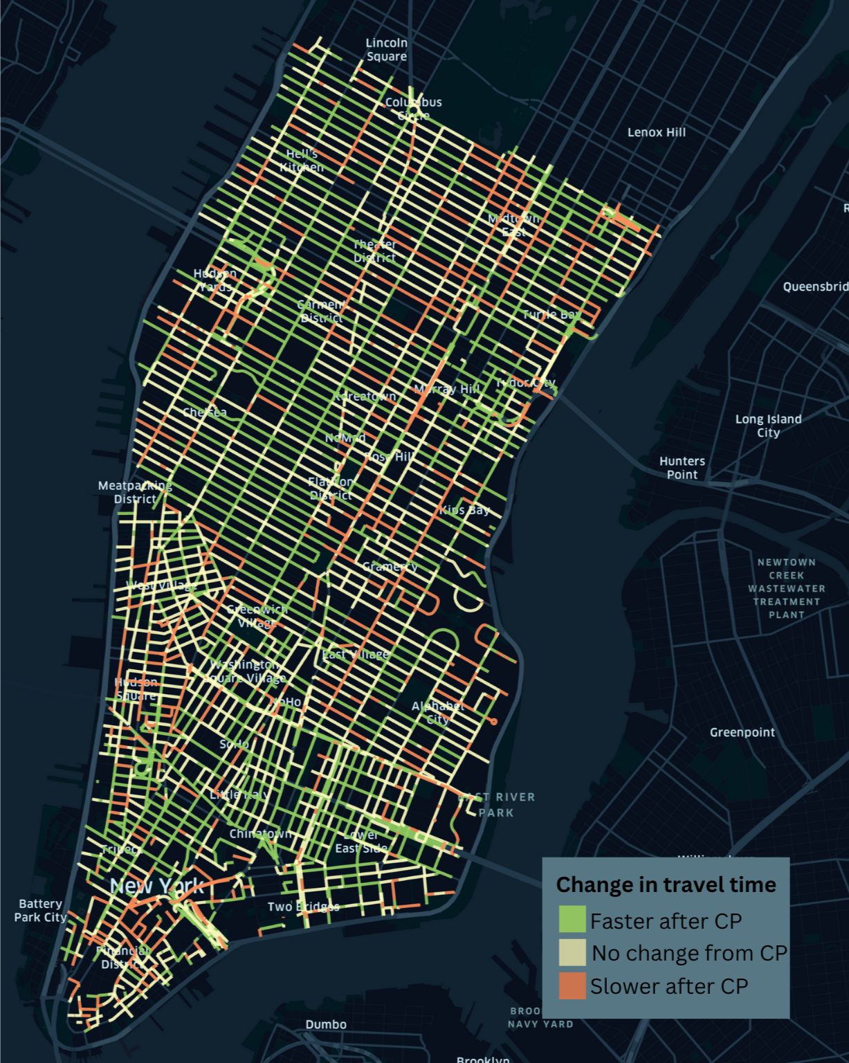
The map shows how average travel time on each road has been impacted by CP.

The analysis shows a noticeable decrease in the number of large trucks (medium- and heavy-duty) and an increase of multi-purpose vehicles in the congestion zone.
"Data insights are crucial for understanding and optimizing the dynamic world of transportation,” notes Nate Veeh, AVP, Business Development, Altitude by Geotab. “This study is a great example of how insights into a real-world problem like traffic congestion and introducing tolls can help us understand the impacts on traffic flow, fleet composition and idling. By leveraging this information, transportation planners and city officials can make informed decisions about transportation options that show results, whether it is to enhance safety, improve efficiency, or facilitate better planning for the movement of people and goods.”
These initial insights from Altitude by Geotab underscore the power of detailed freight mobility data to deliver a deep understanding of evolving urban dynamics and supply chains. As cities like New York implement transformative policies, continuously analyzing complex interactions between vehicle types, traffic patterns, and operational habits through robust data becomes foundational for informing decisions that shape efficient and sustainable urban environments for all.
For more information, visit https://altitude.geotab.com/news-and-releases/nyc-congestion-pricing-analysis/
About Altitude by Geotab
Altitude by Geotab is a leading provider of advanced mobility insights and solutions for public and commercial sectors across North America. Headquartered in Oakville, Ontario, the company leverages its expertise in data analytics to help decision-makers gain a comprehensive understanding of road network movements. By delivering reliable and contextualized insights, it enables improved planning capabilities and better financial outcomes, while maintaining data confidentiality and privacy. Our solutions drive safer, more efficient and more sustainable mobility throughout North America. Learn more at altitude.geotab.com and follow us on LinkedIn.
Media Contact
Nicole Riddle
Media Relations Manager
pr@geotab.com
About Geotab
Geotab is a global leader in connected vehicle and asset management solutions, with headquarters in Oakville, Ontario and Atlanta, Georgia. Our mission is to make the world safer, more efficient, and sustainable. We leverage advanced data analytics and AI to transform fleet performance and operations, reducing cost and driving efficiency. Backed by top data scientists and engineers, we serve approximately 100,000 global customers, processing 100 billion data points daily from more than 5 million vehicle subscriptions. Geotab is trusted by Fortune 500 organizations, mid-sized fleets, and the largest public sector fleets in the world, including the US Federal government. Committed to data security and privacy, we hold FIPS 140-3 and FedRAMP authorizations. Our open platform, ecosystem of outstanding partners, and Geotab Marketplace deliver hundreds of fleet-ready third-party solutions. This year, we're celebrating 25 years of innovation. Learn more at www.geotab.com and follow us on LinkedIn or visit Geotab News and Views.
GEOTAB and GEOTAB MARKETPLACE are registered trademarks of Geotab Inc. in Canada, the United States and/or other countries.
Geotab in the News
March 25, 2026
March 25, 2026
March 19, 2026
March 18, 2026
Related News

Cargo Theft Firmly in the Cyber Era as Losses Exceed 6 Billion, Geotab Warns
March 19, 2026
2 minute read

Altitude by Geotab Data Reveals Average of 15% Efficiency Boost in NYC Congestion Zone
March 18, 2026
2 minute read
Geotab Launches ‘Geotab Build’ to Unify Mixed-Fleet Management for the Construction Industry
March 3, 2026
1 minute read