Collision reconstruction data
Accelerometer and GPS data can be used by collision reconstruction experts to complement environmental data collected from the field, such as tire marks.
By Geotab
May 2, 2025
This article is focused on collision data reconstruction using a Geotab fleet management device. Although many in-vehicle tracking devices on the market have many features, not all are capable of providing collision reconstruction data.
Acceleration Data
An in-vehicle tracking device with a built-in accelerometer has a large role in collision data reconstruction. Collision reconstruction experts can use the accelerometer and GPS data to complement environmental data collected from the field, such as tire marks, and vehicle impact from body damage. Each second 100 accelerometer readings are analyzed by the Geotab device in a 3-axis format consisting of forward/back, side and up/down movement.
Data Storage
The amount of data storage in a vehicle tracking device is very important, particularly when a collision occurs following a long driving period outside a network coverage area. Geotab tracking devices can typically store up to three weeks of data, and the last 102 minutes of driving data. The continuous logging memory is divided into two separate sections:
- The logging data section, which consists of 39,936 records
- The high resolution data, which consists of 6,120 records
The logging data section is uploaded to the client database on an ongoing basis, which includes accelerometer records and GPS data. A portion of the high resolution second by second logging will only be uploaded automatically if a predetermined collision level threshold is exceeded.
Auto Calibration
A tracking device that can automatically calibrate with the vehicle movement will ensure that the accelerometer data will be logged, regardless of the orientation at time of installation. In the rare case that the tracking device changes orientation, the Geotab device regularly analyzes the accelerometer readings to automatically re-calibrate. Although, Geotab does a very good job of filtering noise, it is very important to secure the installation to avoid false collision level thresholds, particularly if the device is installed in a storage area of the vehicle where the device can be knocked during package loading.
Tip: If the device up/down g force deviates from 9.8 m/s2 by more than ±3 m/s2, this is a good indication that the device is changing orientation.
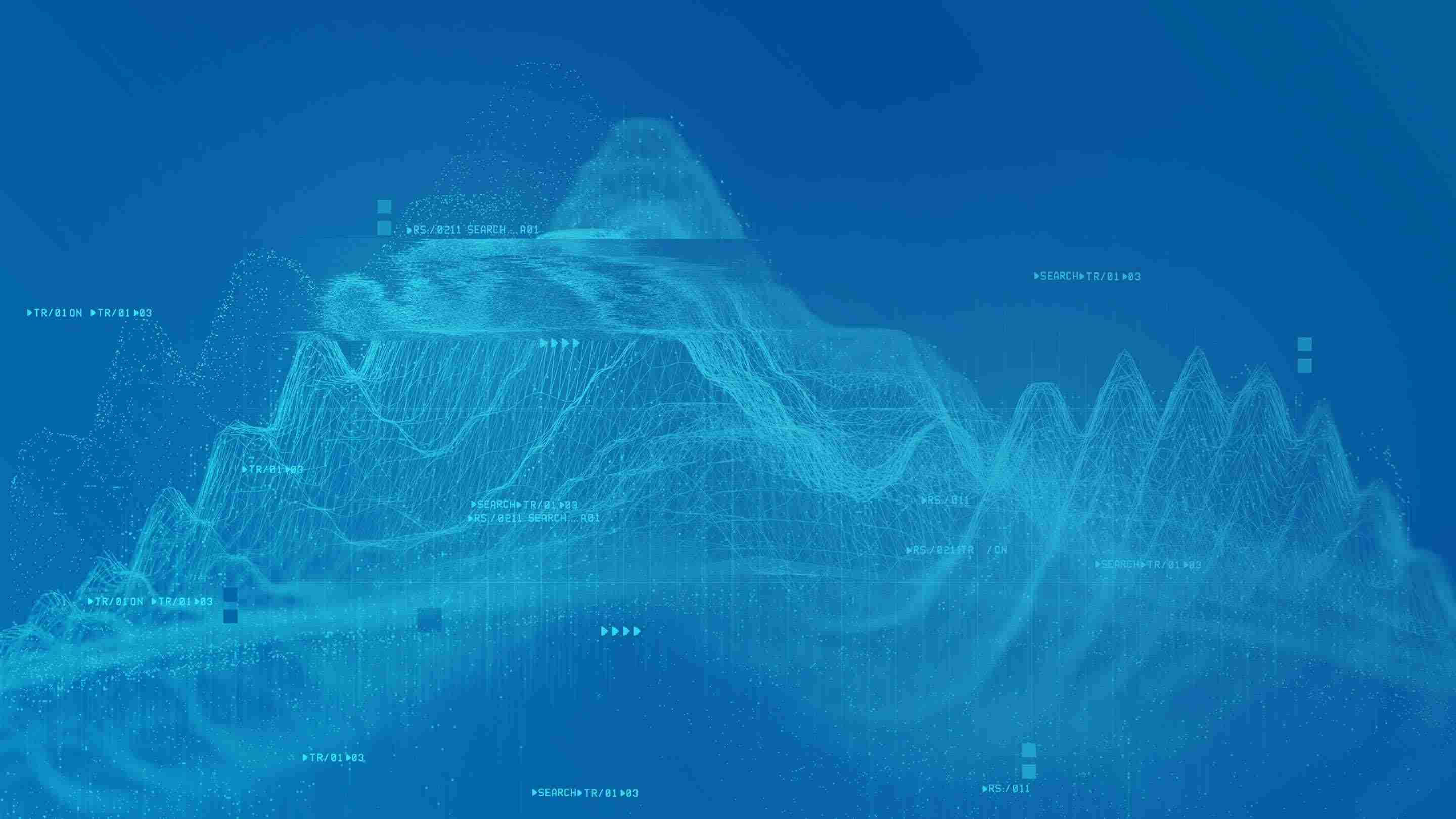
Collision Threshold Tuning
In order to fine-tune the collision threshold, Geotab hired a stunt driver to conduct a controlled collision environment. Several collision scenarios were conducted to ensure that the most valuable data can be captured with the least amount of cellular data usage. The results of the collision are shown in the graph above. The impact triggered an collision level threshold in Geotab’s GPS fleet management software, with a change in acceleration of nearly 38 m/s2.
Note: A Geotab device will report an collision level event if there is a change in acceleration of at least 24.5 m/s2.
The graph is generated based on a 5km/h impact consisting of a 2003 Chevrolet Cavalier driving into a median, conducted by a professional stunt driver. The vertical axis is shown in units of 9.8 m/s2, while the horizontal axis is in seconds.
An in-vehicle tracking device will not only improve safety by changing the behavior of the driver’s habits using in vehicle driver feedback, it will also ensure that you have access to the collision data in a timely manner.
Contact Geotab for more information on the importance of having accurate collision reconstruction data.
Subscribe to get industry tips and insights
Geotab team
Subscribe to get industry tips and insights
Related posts

Construction fleet management software: What mixed fleets should look for
July 29, 2026
5 minute read

From video archives to active prevention: The case for AI dash cams
July 22, 2026
4 minute read
Closing blind spots in cargo security with a 360 fleet camera system
July 22, 2026
3 minute read

B.C.'s Dashcam Mandate Creates an Opportunity for Safer Roads Across Canada
June 5, 2026
2 minute read
B.C.'s new dash cam law: A six-month clock is about to start for commercial fleets
June 2, 2026
5 minute read