What’s new in MyGeotab — Version 10.0
Welcome to our latest summary of updates in MyGeotab.
Dec 8, 2023

MyGeotab users: To verify your version, go to MyGeotab > Administration > About, and check the build number, (e.g. 10.0.0-release).
Early feature access
If you would like to test out new features before they are widely available, you can register a database on the preview servers to gain early access.
If you would like to submit feedback regarding new features, you can do so at any time via the Community or your Partner.
Sign up for Geotab news
Stay up to date on what’s new and subscribe to the Geotab newsletter to get these update posts emailed to you.
What’s new in Geotab Drive
Refer to What’s new in Geotab Drive — Version 10.0 for information on new ELD/HOS features for this release.
If you have suggestions for improvement, please leave a comment below!
| ✱ NOTE: The images shown here are for illustration purposes only, and may appear different in the software as we approach the final release. |
New changes - Action required!
The following changes included with this release require action by you or your administrators/users and may affect your workflows:
Default purge settings
- Starting in the 10.0 release, the default purge frequency for new databases will be set to two years, and enabled on the database by default. The default purge frequency means that older data than two years will be deleted from the database.
- The updated default purge frequency for new databases will be retroactively updated on MyGeotab databases with software version 7.0, 8.0, and 9.0.
- REQUIRED ACTION: To modify the default purge frequency, go to the Administration > System… > System Settings page and select the Purge tab.
✱ NOTE: The purge frequency for existing databases has not been changed.
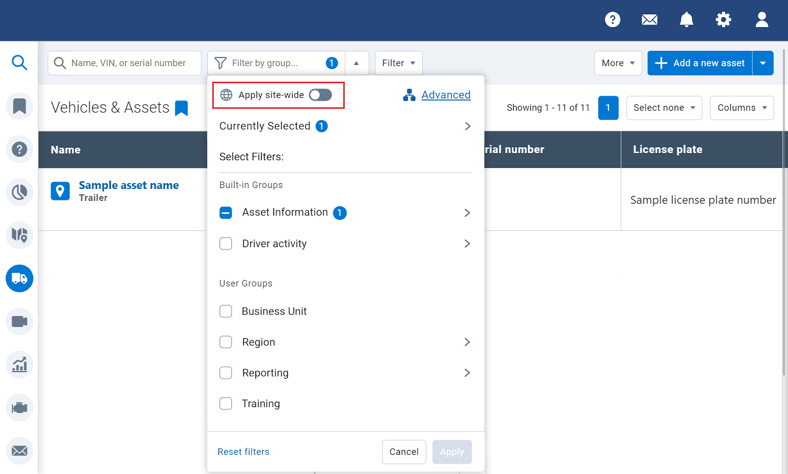
New In-page Groups filter
- We’ve developed a new Groups filter in Feature Preview to replace the current Groups filter.
- The new Groups filter will replace the current Groups filter in the top left corner of the screen.
- There are two ways to use the new Groups filter:
- Filter for groups on the current page only.
- Enable the Apply site wide option to leverage the same filter on other pages within MyGeotab.
- REQUIRED ACTION: You can shape the future of this feature! Go to User options > Options in the top-right corner to turn on the Groups filter Feature Preview settings under the Feature Preview tab to test the capabilities of the filter. After you’ve had a chance to test the new in-page Groups filter, fill out the feedback survey to tell us what you think of the new changes!
MyGeotab SDK - v10.0 Nuget Package
- We’ve made a performance optimization to ObjectModel classes by marking them “sealed”.
- Integrators using the Nuget package and extending Geotab Objects will receive a compilation error upon upgrading to v10.0 of the Nuget package.
- REQUIRED ACTION: Create your own POCO objects to avoid extending the objects from the Nuget package.
✱ NOTE: You may use the v9.0 Nuget package temporarily until you are able to make the necessary changes to upgrade to v10.0.
Vehicles and Assets
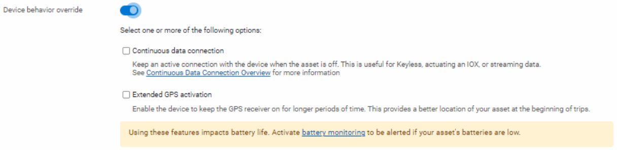
Device behavior override introduction
Region: Global
We’ve added a new feature for GO9 and newer devices: Device behavior override. Device behavior override allows Partners and Customers to modify GO device behavior when an asset is off through the Continuous data connection and Extended GPS connection overrides.
✱ NOTE: Use of either the Continuous data connection or Extended GPS activation overrides will adversely affect asset battery life. Geotab recommends use of the Battery Drain rule under Rules & Groups > Rules in order to be notified of potential battery drain events when using these overrides.
Continuous data connectionContinuous data connection (previously referred to as Continuous Connect) modifies the GO device’s modem behavior when an asset is off.
Continuous data connection maintains a cellular connection between the GO device and MyGeotab at all times, which is helpful to receive Keyless commands, actuate an IOX, or stream data from MyGeotab to the GO device.
For more information, refer to Continuous Data Connection Overview [PUB]. | Extended GPS activationExtended GPS activation (previously referred to as Periodically wake GPS) modifies the GO device’s GPS behavior when an asset is off.
Extended GPS activation extends the amount of time that the GO device’s GPS module is active when an asset is off, to ensure an accurate GPS location is found for the beginning of the next trip.
|
✱ NOTE: Continuous data connection requires GO firmware versions x37.21 and x38.15 or newer in order to function. Please update your firmware when available.
To access Device behavior override, navigate to the Vehicles & Assets page and select an asset. On the Asset Edit page, select the Settings tab and expand the Advanced section. Enable the Device behavior override toggle, select one of the options, then click Save.
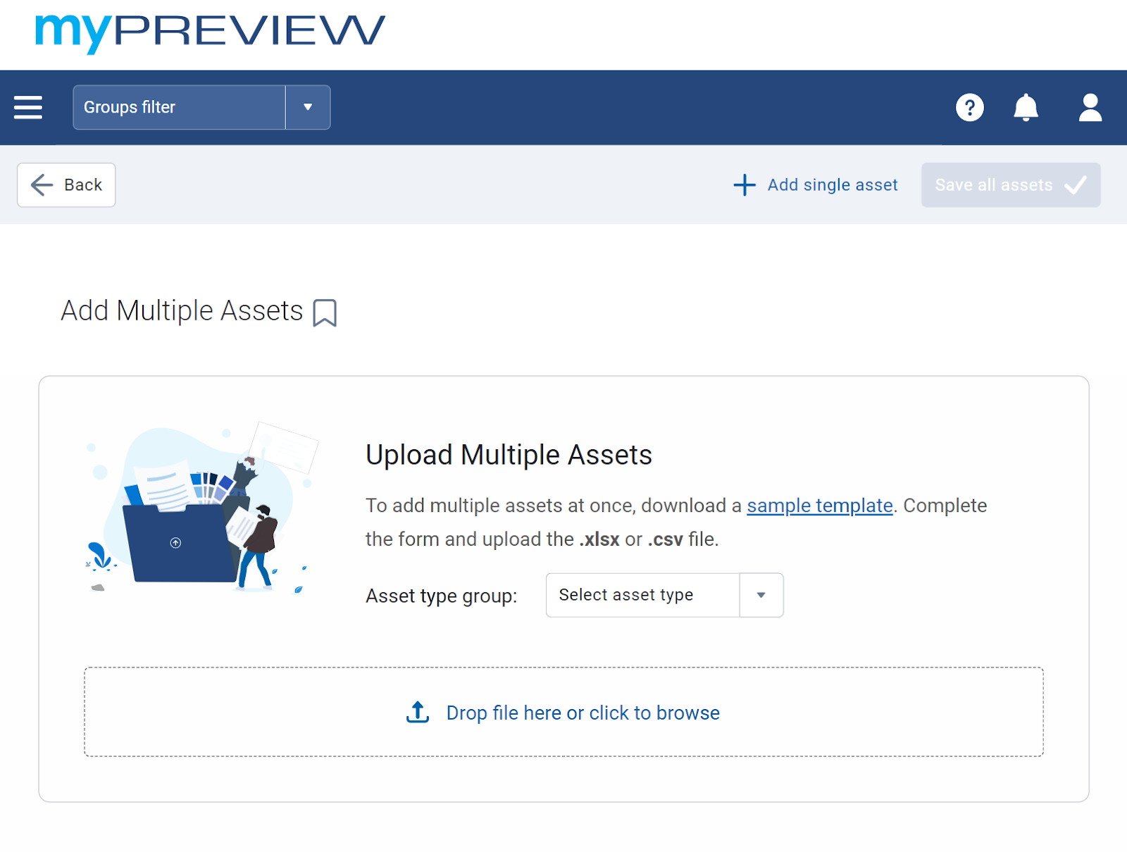
Workflow for adding new assets
Adding assets in MyGeotab just got easier! We’ve added a new Add a new asset button on the Vehicles & Assets page, so you can add a single asset or multiple asset using a single menu.
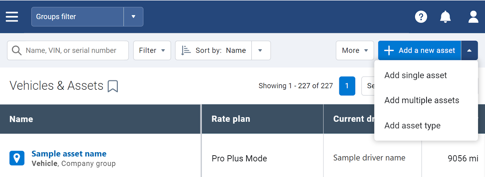
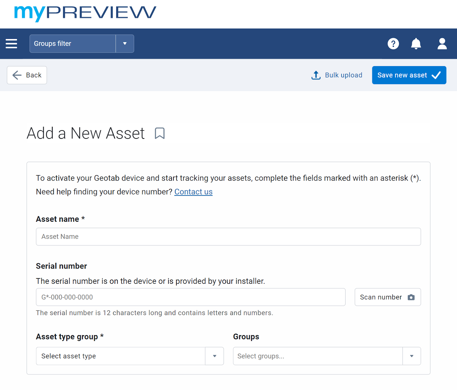
Additionally, we replaced the Quick Import pop-up window. Now, when adding multiple assets, you can now upload a spreadsheet with the list of the asset information on the Add Multiple Assets page.
Groups
In-page groups filter
We’ve developed a new Groups filter (available in Feature Preview) to replace the current Groups filter. The new Groups filter can be used in two ways:
- Filter for groups on the current page only.
- Enable the Apply site wide option to leverage the same filter on other pages within MyGeotab.
Also, on the Vehicles & Assets page only, the new Groups filter replaced the Show Assets filter.
✱ NOTE: The new Groups filter is not yet available on all pages in the MyGeotab application.
We want to hear from you! Tell us what you think of the new changes by filling out the feedback survey.
Activity
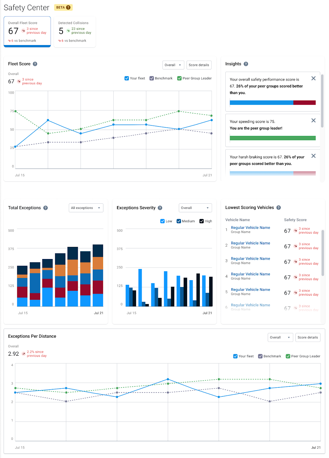
Safety Center
We are excited to introduce Safety Center in Feature Preview! Safety Center is a one-stop shop for your safety-related information. It provides Fleet Managers and Fleet Administrators with fleet optics and exception insights, allowing you to compare to other fleets of similar size and groups, as well as Peer Group Leaders.
Use Safety Center to view your Fleet Score, Insights, Total Exceptions, Exceptions Severity, the Lowest Scoring Vehicles in your fleet, and Exceptions per Kilometer.
✱ NOTE: Safety Center is powered by Geotab’s DnA engine. The information that displays on this page differs from the information that displays on the Exceptions page.
To access Safety Center, follow these steps:
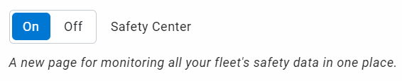
- From the User options dropdown menu, select Options > Feature Preview.
- Enable the Safety Center toggle, then click Save.
3. Navigate to the Activity page from the MyGeotab main menu, then select Safety Center.
✱ NOTE: Safety Center does not support the Group feature, and therefore only users with Administrator clearances can access the feature in 10.0 version of MyGeotab.
We value your feedback in our effort to develop simple and efficient solutions. Please share your thoughts on the Maintenance Center using the Feedback Hub
Refer to the Safety Center User Guide for more information.
Map
Ongoing improvements to Share Asset Location
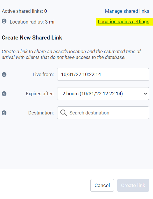
We’re continuing to improve the design and usability of the Share Asset Location feature. We’ve added a Location Radius Setting to accommodate use cases where Customers may need visibility of longer distances between the asset and the target destination.
To access the feature, navigate to the Administration > System… > System Settings page, select the Maps tab, then modify the radius limit in the Map Location Sharing Radius section. You are able to specify a radius distance between 1 and 500 km. This allows you to change the global settings for location sharing.
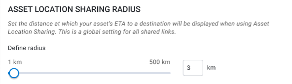
You can also use the Location Radius Setting feature through the Map page by clicking on the asset on the Map, then selecting Share Asset Location option from the dropdown menu. In the Location Sharing window, click Location radius settings to define the location radius limit.
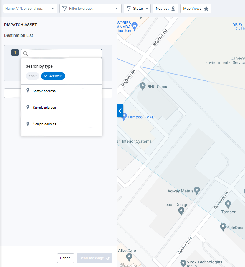
Dispatch asset from the Asset card on the Map
For your convenience, you can now dispatch an asset without leaving the Map! Dispatch an asset from the Asset panel by clicking the Dispatch asset button.
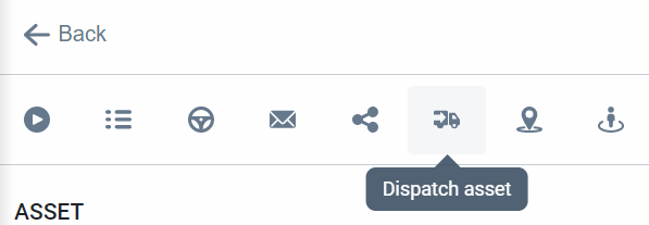
From the Dispatch Asset panel, you can dispatch the asset to any address or zone, and also attach a message to the driver.
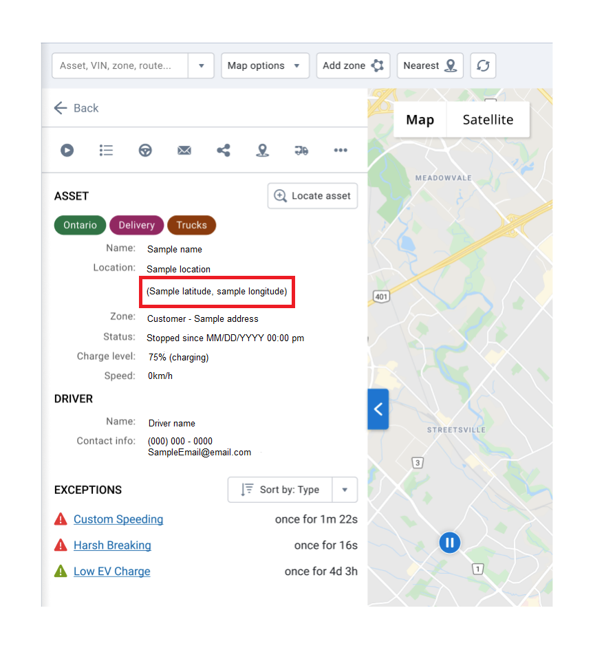
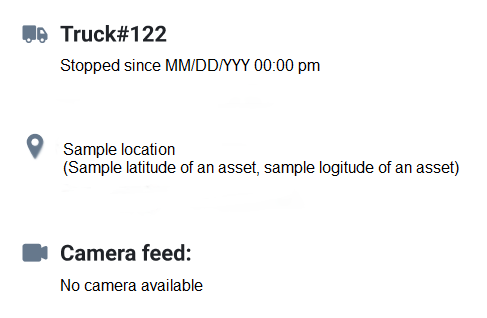
GPS coordinates displayed when an address is not available
We’ve made it easier to locate assets when an address is not available. Now, you can view an asset’s location in the Asset panel, Asset list, and the tooltip on the Map based on the latitude and longitude of its location.
Asset’s latitude and longitude in the Asset panel
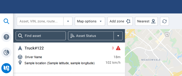
Asset’s latitude and longitude in the Asset list
Asset’s latitude and longitude in the tooltip on the Map
Reports
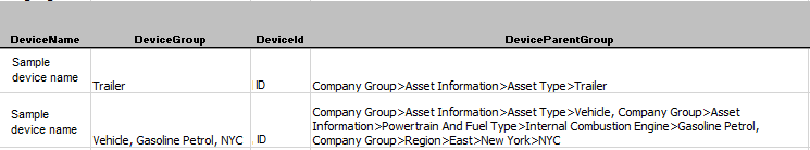
New optional report header for group hierarchy
You asked, and we listened! You can now add a new optional column called DeviceParentGroup to the Data sheet of any custom report to get the full hierarchy of the groups associated with the device.
The DeviceParentGroup column is useful for building logic into your custom report to compare different branches in your organization, compare different fuel type assets, and so on.
As an example, the DeviceParentGroup column may also be useful in cases where a utilization report must include the Parent group before sending the report to billing departments.
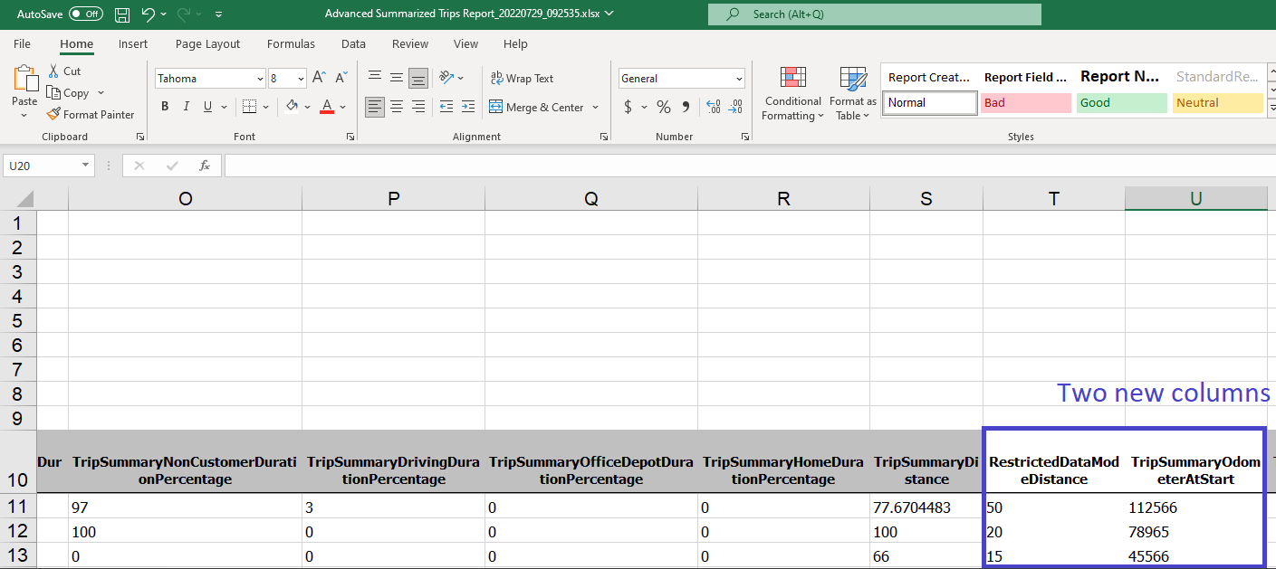
New optional data columns added to Trips Summary reports
We’ve added two new columns to the Data sheet of the Trips Summary reports (Standard and Advanced):
- RestrictedDataModeDistance — Displays the distance traveled while the asset is in restricted data mode (Feature Preview).
- TripSummaryOdometerAtStart — Displays the odometer value at the start of the trip.
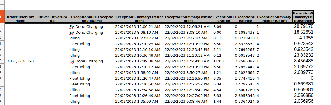
New TripDistance per Device/Driver on the Exception Summary report
We’ve added an optional column to the Exception Summary report (Standard and Advanced) that can also be included in custom reports: ExceptionSummaryTripDistance. The ExceptionSummaryTripDistance column displays the total distance traveled per row of data per asset or driver.
You can now compare when or if an asset is continuously driving while breaking the same exception rule without having to create a separate rule to monitor total distance traveled by the asset.
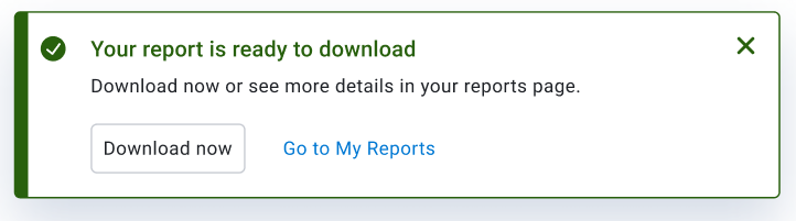
Download and email reports directly from the My Reports page
You can now download larger reports while logged in with fewer clicks! The My Reports page allows you to download and save reports that are too large to be emailed.
When you begin downloading a report on your database, we’ve added a notification to inform you of the progress of your report and another notification indicating when it is ready to download.
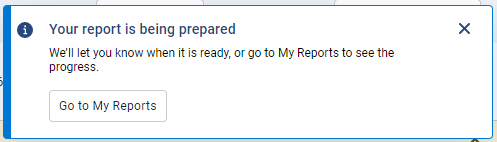
Click the Go to My Reports button, or click the User options dropdown in the top right corner of your database, then click My reports.
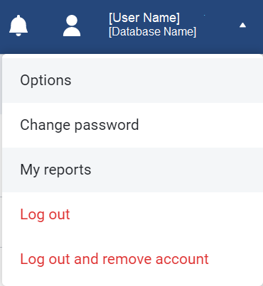
Once you receive the notification that your report is ready, click the Download now button.
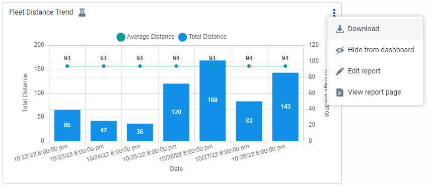
Added new options to your Interactive charts on your dashboard
We’ve added the following new options to the Interactive charts on your dashboard:
- Download – Download the Interactive chart displayed on the dashboard.
- Hide from dashboard – Hide the Interactive chart displayed on the dashboard.
- Edit report – Edit the report associated with the Interactive chart displayed on the dashboard.
- View report page – View the report associated with the Interactive chart displayed on the dashboard.
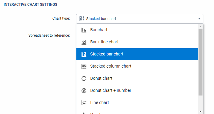
Added stacked bar and column charts to Interactive reports
To prevent visual overload, you now have the option to display Interactive reports as a Stacked bar chart and Stacked column chart. Access this option by navigating to the Report Setup page, and under the Interactive Chart Settings, configure the Chart type to display as either Stacked bar chart, or Stacked column chart.
Rules
Stock Idling Rule Alignment
For consistency, the Idling stock rule is updated to match the conditions used for handling Trips — the asset must be stopped with ignition on for three minutes and 21 seconds.
✱ NOTE: We do not expect any major impacts or changes in the exception behavior with the change to the Idling stock rule.
Enhanced Rule Conditions Configuration
We’re making things easier! You can now edit the condition or create custom rules for certain rule types. For this release, the option is available for the Idling stock rule and, by default, the Edit Stock rules clearance is enabled.
Use the Edit dropdown menu to Edit conditions or Create custom (rule name) rule.
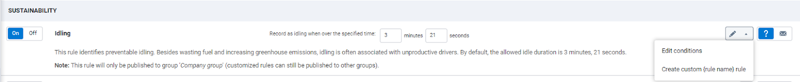
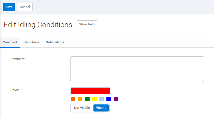
The Edit conditions option refreshes the page to display the Edit Idling Conditions page. On the Edit Idling Conditions page, you can add a description and assign a color, and configure the settings under the Conditions and Notifications tab.
✱ NOTE: When editing conditions of an existing rule, you cannot change the name of the rule or publish to a group.
The Create custom [rule name] rule option refreshes the page to display the Exception Rule Edit page. On the Exception Rule Edit page, you can name the rule, assign a color, and publish to groups, as well as configure the settings under the Conditions and Notifications tab.
Settings
Default Purge settings
For newly created databases, the default purge frequency is set to two years, and enabled for the database by default. To modify the settings, go to the Purge tab on the Administration > System… > System Settings page.
This feature will be retroactively updated in software version 7.0, 8.0, and 9.0 for any newly created databases.
✱ NOTE: The purge frequency settings for existing databases have not been changed.
Trips History
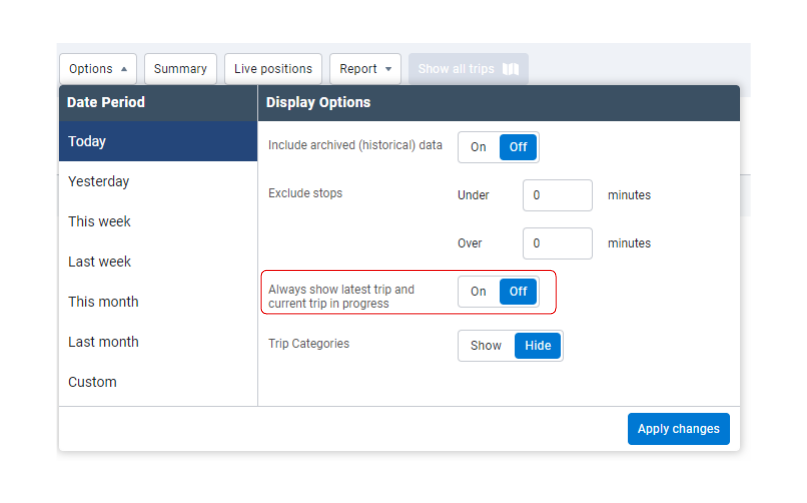
Current trip in progress option out of Feature Preview
The option to Always show the latest trip and current trip in progress is now out of Feature Preview! To enable this feature, use the Options dropdown menu on the Trips History page, and configure the Date Period to Today or a Custom date starting no earlier than the current day. In the Display Options panel, enable the Always show the latest trip and current trip in progress toggle and click Apply changes.
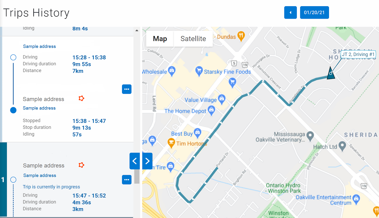
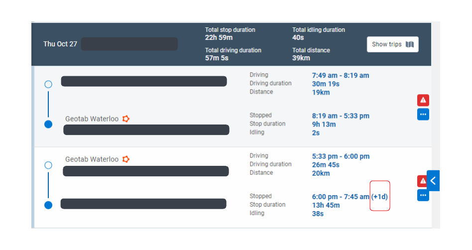
Improved Indication of Trips Spanning Multiple Days
You can now see the exact time that has passed since the beginning of a trip. Previously, only the timestamps for Trips and Stops display on the Trips History page, which can be misleading when they span over multiple days. To indicate that a trip spans over multiple days, we’ve added the number of elapsed days in parentheses beside the timestamp.
HOS Logs
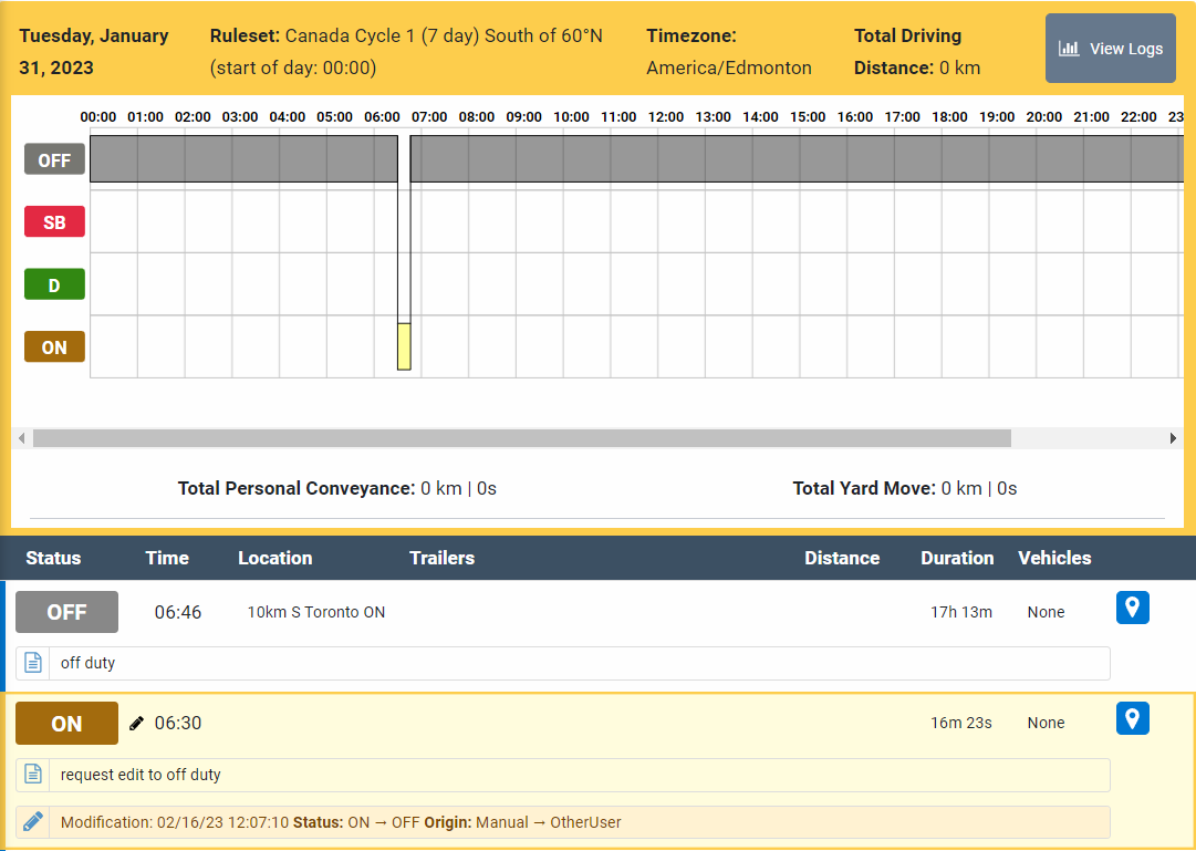
Driver’s RODS on Graph Grid
Previously, the Driver’s graph in MyGeotab displayed the requested edits before the edits were accepted by the driver. Now, only the official RODS on the Driver’s record is displayed on the graph.
If there is a requested edit for the day, the graph is still outlined in yellow, and the requested edit is highlighted in yellow under the list of RODS displayed with View Logs.
UI Enhancements
We’ve added the following UI enhancements with this release:
- Updated asset card view to include option to assign driver.
- Updated asset card view to display historical driver information in italicized text.
- Removed default zone display and Default map view under the Map Settings tab on the Options page.
- Improved Audit Log page to display details when System Settings are modified.
MyGeotab Add-in Updates
Drive Add-In
- Added the following Drive App Add-Ins:
- onStartup – Add-in is executed when a driver logs in to the Drive App for the first time.
- onShutdown – Must be set to true to execute an Add-in when logging out of the Drive App.
These Add-ins execute code in the background when the application starts. Otherwise, the Add-in code only executes when it is clicked.
SDK Updates
API Runner (SDK)
The following improvements are added:
- Added loading spinner to indicate to users that the login request is being processed.
- Added a keypress handler for the login form that allows the cursor to move to the next field, and added functionality for an enter key press event to submit the form when inputting information in the last field.
- Fixed an error message occurring in the main .js:scrollSidebar.
- Fixed an issue that caused multiple click handlers to be added to the login button.
SecurityIdentifier
- Added the ImpersonateGpsTextMessage security identifier. When enabled, the security identifier does not validate the identity of the sender.
- Added the ResetPassword security identifier that allows a user to reset another user's passwords.
mg-api-js
We’ve corrected the following errors:
- Fixed UnhandledRejection exceptions.
- Improved exception messages to include the type from the JSON-RPC error.
- Fixed InvalidUserException retry authentication.
- Updated CallBackError to be invoked as the last operation in the promise field.
GetFeed<FuelTaxDetail>
- Fixed issues with results sorting that led to missing results.
Nuget
- Enabled brotli compression in Nuget package API.cs requests.
- Many ObjectModel classes are marked as “sealed”. Marking a class as “sealed” prevents tampering of important classes that can compromise security or impact performance.
! IMPORTANT: Updating your application to version 10.0 may not work if an ObjectModel class is inherited.
TextMessage
- Added PropertySelector (Beta) support for the TextMessage type.
IoxAddOn
- Added PropertySelector (Beta) support for the IoxAddOn type.
IoxAddOnStatus
- Added PropertySelector (Beta) support for the IoxAddOnStatus type.
DriverChange
- Updated the description of DriverChange DateTime to notify users that the DateTime must not be in the future when adding a DriverChange through API.
DriverWhiteListContent
- DriverWhiteListContent is replaced by DriverAuthListContent
- Prior to the 10.0 release, DriverWhiteListContent and DriverAuthListContent were both available to allow users to adjust to the transition.
Condition and ConditionType
- Added the Group exception rule condition. This separates conditions in a single rule when different groups require different conditions.
Geotab Developers
- Added a section to the Developing Add-ins page suggesting to use the generator-addin repository.
SDK samples
- Added JavaScript samples to refresh the user interface.
SDK Add-In samples
- Added Add-In samples for the AddInData API to the Geotab/sdk-addin-samples Github repository.
Subscribe to get industry tips and insights
The MyGeotab and Technical Writing Teams write about MyGeotab updates for Geotab.