What’s new in MyGeotab — Version 1902
Read the latest summary of updates in MyGeotab.
Jan 14, 2022

Welcome to our latest summary of updates in MyGeotab.
Geotab Users: To verify your version: go to MyGeotab > Administration > About and check the build number, (e.g. 5.7.1902.xxx release).
Resellers: Review this post for important changes affecting your customers and note any recommendation actions. If you have suggestions for improvement, please leave a comment below.
Sign up for Geotab news
Stay up to date on what’s new. Please subscribe to the Geotab newsletter to get these update posts emailed to you.
User interface (UI) enhancements
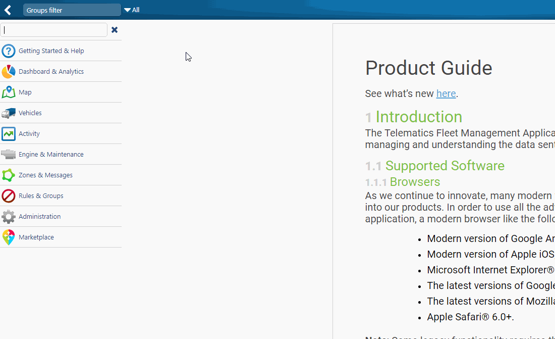
New menu search option
Find what you need faster with the new MyGeotab menu search function. Just click the search icon at the top of the menu. Search by keyword or by name to quickly find the page you are looking for.
Tip: Use the shortcut keys: Shift + F to get to the search menu
“Historical” will be renamed as “Archived”
MyGeotab will now refer to “Historical” assets as “Archived” assets. During the 1902 release period, the term “Historical” will appear in brackets. Geotab will remove this term altogether in a future release.

“Accident” will be renamed as “Collision”
To better align with our industry partners, MyGeotab will now refer to “Accident” events as “Collision” events. This includes all Excel reports as well as the Product Guide. Read more about Geotab’s Collision Reconstruction Add-In for MyGeotab here.
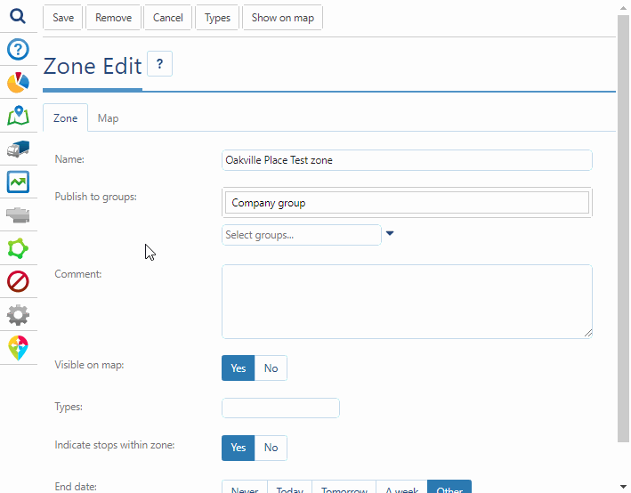
Zone edit page includes new Map tab
Zones can now be edited directly on the Zone Edit page. Click the Map tab to open up the editing panel. Drag and drop to change the Zone shape, select a custom color, and increase or decrease the transparency. Use the Preview button to verify. A preview feature has been added to preview your changes before saving.
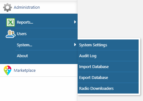
Removed Import Database, Export Database and Radio Downloaders from the System menu
Geotab removed Import Database, Export Database and Radio Downloaders from the Administration > System menu. These features are no longer in use and have been hidden.
Electric vehicles
Fuel Usage Report renamed to “Fuel and EV Energy Usage” and now includes EV energy consumption
Managing both gasoline and electric vehicles? We’re here to make it easier for you. The Fuel Usage Report has been enhanced to include support for Electric Vehicles (EVs) and is renamed as the “Fuel and EV Energy Usage report.” Accordingly, the Security Clearance for “Fuel Use Report” is now also named “Fuel and EV Energy Usage Report.” Now, you can compare the performance of both your conventional and EVs together in one easy-to-read report.


The report will continue to show fuel usage and fuel economy for conventional vehicles, plus show electric energy used and electric energy economy for electric vehicles. Electric vehicle data reported includes both Battery Electric vehicles (BEV), which do not consume fuel, and Plug-in Hybrid Electric Vehicles (PHEV), which consume fuel and electric energy.
To evaluate whether a Plug-in Hybrid Electric Vehicle (PHEV) is running predominantly on gas, the Fuel and EV Energy Usage Report also displays % Electric Energy of Total.

Report users will have the ability to select the preferred electric energy economy measurement (metric or US/Imperial). By default, this will take the equivalent value from your fuel economy choice.

EV Charging Activity is now displayed on the Map (Feature Preview)
MyGeotab users who have Feature Preview enabled, and current/future Beta Firmware on supported EV makes and models, can now view the following EV charging activity on the MyGeotab Map:
- Real-time battery charge percent for individual vehicles — See the State of Charge (SOC) while driving (available with firmware version 25+). For EVs using the Geotab GO9 with future firmware version 26+, this feature is extended to include real-time battery charge percent while charging.
- For EVs using the GO9 with future versions 26+, this feature is extended to include real-time charging status.

EV Charging Report (Feature Preview)
Understand your fleet’s full EV charging history with the new EV Charging Report. See where, when, and how often fleet drivers have charged their EVs. Note: To take advantage of this report, users must have Feature Preview enabled, and future firmware version 26+ on supported EV makes and models. The EV Charging Report is conceptually similar to fill-ups, but for EV energy instead of fuel.
The EV Charging Report includes:
- EV electric energy added per charging session
- Location and zones, with ability to filter on Zones
- Duration
- Start and end battery charge %
- For advanced reporting use cases:
power
current type (AC or DC)
AC voltage
electric energy economy since last charge

Privacy Mode: EV Charging adheres to Privacy Mode and will not reveal charging location information for when that mode is enabled.
Related Clearance Change: The former clearance name “View fill-ups and fuel transactions” is now “View fill-ups, EV charging, and fuel transactions”. This existing clearance was extended to include EV Charging, given the similarity of vehicle fueling, either with traditional fuel or electric energy.
New for PHEVs in Fill-Ups: Fuel Economy not reported when electric energy consumed
With our commitment to data accuracy, when a PHEV uses both fuel and EV energy after the last fill-up, the fuel economy for that period is no longer reported in Fill Ups. If a PHEV continues to report fuel economy while consuming electric energy, the fuel economy value may appear falsely positive.
Report enhancements
Added last quarter as a pre-defined date interval for the IFTA report
Users can now run IFTA reports for the last quarter easily by using this option, in addition to the existing list of time intervals, including Today, Yesterday, Last week, Last month, and others.

The Address column has been removed from the "Business vs Personal" Dashboard Report
To speed performance, the Address column was removed from the “Business vs Personal” Dashboard Report.

Improved Excel report file naming conventions
All downloaded Excel reports will follow the naming convention: templatename_yyyymmdd_hhmmss.xlsx.
New User Option to opt in, or out of receiving email reports
Opt a user in or out of email reports in one quick click. The UI Settings feature now allows Administrators to set this option when creating new users in MyGeotab. Existing MyGeotab users are set to On by default, but they can change this option themselves should they choose to opt out of receiving emailed reports.

“Work Time” is now an available column on the Excel device report
The Work Time feature can be used to view the current work times for vehicles in the MyGeotab Portal. Work Time is configured by the user.
Other updates
Password confirmation required before enabling purge - Feature Preview
Before enabling the Purge feature in MyGeotab, the user is now prompted to re-enter their password in order to confirm their new purge settings. Note: If you are a Security Assertion Markup Language (SAML) user, you will only receive a prompt to confirm your settings. You will not be prompted to enter your password. Simply enabling the Purge feature in MyGeotab will not initiate purging. To enable the Purge feature, you must contact your Reseller and create a support ticket with Engineering Support.

Certificates for SAML are now out of Feature Preview
For Customers who utilize SAML 2.0 for single sign-on, the Certificates tab no longer requires Feature Preview. SAML users can now find the Certificates tab under Administration > System > System Settings.

New user account policy settings available
Administrators can now specify basic or SAML user authentication types in MyGeotab.

Added VIN/PIN to Quick Import feature on Vehicles page
When navigating to Vehicles > Add > Quick import, users can now choose to include the VIN/PIN when importing vehicles into MyGeotab. Note: If a vehicle does not have a VIN, OEM data providers will assign a unique PIN to the vehicle. Common examples include earth-moving equipment (bulldozers, excavators, etc.)
Flex device now supports additional properties on the Edit page
The Flex Solar Asset Tracker now includes the same properties in MyGeotab as other third-party solutions for vehicles. These include VIN, license plate, odometer and engine hours among others.
Added third-party license agreements for open source attributions on the Credits Page
MyGeotab uses various open source software components in which links to their respective attribution license agreements, are now available under Administration > About > Credits.

Mandatory government organization question added to Registration and System Settings pages
We have added a mandatory question to the Registration page and the Administration > System > System Settings page. The question requires registrants to indicate whether or not they are part of a government organization.

Fixed default rules to match values in description
We have adjusted the values for the default rules under Rules & Groups >Rules to match the descriptions. See the correct values below:
- Long lunch - 60 minutes (previously 20 minutes)
- Idling - 5 minutes (previously 20 minutes)
- Fleet Idling - 5 minutes (previously 20 minutes)
- Too Much Office Time - 90 minutes (previously 20 minutes)
- Long Stops During Work Hours - 60 minutes (was 60 minutes)
Diagnostic code updates
- New and revised engine diagnostic codes have been added.
- Engine diagnostic descriptions have been translated into all available languages. MyGeotab will now display the 100 most popular diagnostics in the language of choice for all MyGeotab users.
For a full list of diagnostics, please get in touch with your Geotab Account Manager.

Other:
Fixed typos, grammar, capitalization, bugs, accessibility, security and translation errors.
MyGeotab SDK Updates
Geotab is introducing result and rate limits to the MyGeotab API
Select APIs are now limited by:
- The number of results that can be retrieved in a single request; and
- The rate at which an API can be requested.
Read more in this blog post: DEV Update: Geotab result and rate limits
Added new User property “isEmailReportEnabled”
Added new User property “isEmailReportEnabled”. Type: Boolean, If [true] the user will receive the emailed report, otherwise [false].
GO9 additions to the SDK
Now that the Geotab GO9 is officially released, we have updated the SDK reference page to include the latest telematics device.
Adding a device will now automatically set the ActiveTo property value to max date. Setting the ActiveTo property for a device to a value in the future, but not max date, will automatically set the value to max date.
When adding a device, the API will automatically set the "ActiveTo" property to be the “max date” value (2050-01-01T00:00:00.000Z).
If a device previously had an "ActiveTo" date that was set in the past (archived state), you can continue to set this property to a past date to keep it archived or set it to the max date, and provide a serial number to reactivate the device. If a device previously had an "ActiveTo" date that was set to the max date (active), you can continue to set this property to a past date to archive the device. In both cases, setting the "ActiveTo" property to a value in the future, but not max date, will cause the system to automatically set the value to max date.
This change was added to maintain consistency and to avoid confusion among users. The "ActiveTo" property must be treated as an expiry date where devices will automatically become archived when the "ActiveTo" date is reached. A device with an "ActiveTo" value set to the max date is considered to be active and any date before the system's current time will be considered archived. Currently, we only support instantaneous archiving for devices.
Performance enhancements have been made to the Proximity Add-In.
For better visibility on the Map, the Proximity Add-In has been updated to use single API requests with limits imposed on the number of results returned.
Added support for Mime Messages for More IOX Add-Ons
Up until the 5.7.1901 update, only a single external device ID was capable of successfully passing MIME type data through to MyGeotab. With this change, a new range of external device IDs will be made capable of doing the same. This will allow partners to leverage this hardware integration functionality.
Added new faults for proprietary data
Diagnostics:
- ProprietaryFaultDiagnostic
- LegacyFaultDiagnostic
- ProprietaryFault and LegacyFault diagnostic types
Controllers:
- ProprietaryFaultController
- LegacyFaultController
Sources (source of Diagnostics and Controllers):
- SourceLegacy
- SourceLegacyObsolete
- SourceProprietary
- SourceProprietaryObsolete
Other SDK updates
General Fixes to errors in SDK documentation.
Previous update
Looking for the last update summary? Read: What's new in Geotab - Version 1901.
Learning resources
For more info on SDK updates, please visit the MyGeotab SDK What’s New page.
Learn more about Geotab Drive, MyGeotab, and the Geotab GO telematics device by consulting these resources:
Contributors:
Vik Sridhar, Product Engineering Manager MyGeotab
Sarah Kerr, Senior EV Product Manager
Heather Holmes, Technical Writing Manager
Subscribe to get industry tips and insights
The MyGeotab and Technical Writing Teams write about MyGeotab updates for Geotab.
Table of Contents
- Sign up for Geotab news
- User interface (UI) enhancements
- New menu search option
- “Historical” will be renamed as “Archived”
- “Accident” will be renamed as “Collision”
- Zone edit page includes new Map tab
- Removed Import Database, Export Database and Radio Downloaders from the System menu
- Electric vehicles
- Fuel Usage Report renamed to “Fuel and EV Energy Usage” and now includes EV energy consumption
- EV Charging Activity is now displayed on the Map (Feature Preview)
- EV Charging Report (Feature Preview)
- New for PHEVs in Fill-Ups: Fuel Economy not reported when electric energy consumed
- Report enhancements
- Added last quarter as a pre-defined date interval for the IFTA report
- The Address column has been removed from the "Business vs Personal" Dashboard Report
- Improved Excel report file naming conventions
- New User Option to opt in, or out of receiving email reports
- “Work Time” is now an available column on the Excel device report
- Other updates
- Password confirmation required before enabling purge - Feature Preview
- Certificates for SAML are now out of Feature Preview
- New user account policy settings available
- Added VIN/PIN to Quick Import feature on Vehicles page
- Flex device now supports additional properties on the Edit page
- Added third-party license agreements for open source attributions on the Credits Page
- Mandatory government organization question added to Registration and System Settings pages
- Fixed default rules to match values in description
- Diagnostic code updates
- Other:
- MyGeotab SDK Updates
- Geotab is introducing result and rate limits to the MyGeotab API
- GO9 additions to the SDK
- Adding a device will now automatically set the ActiveTo property value to max date. Setting the ActiveTo property for a device to a value in the future, but not max date, will automatically set the value to max date.
- Performance enhancements have been made to the Proximity Add-In .
- Added support for Mime Messages for More IOX Add-Ons
- Added new faults for proprietary data Diagnostics:
- Sources (source of Diagnostics and Controllers):
- Other SDK updates
- Previous update
- Learning resources
- Contributors:
Subscribe to get industry tips and insights
Related posts

The plug-and-play rental fleet: Upgrade your technology without missing a single booking
April 27, 2026
5 minute read

The Evolution of Product Updates: Welcome to Your New Centralized Hub
December 15, 2025
2 minute read