Kentucky Transportation Cabinet reports 84,884 mobile work-zone alerts
The Kentucky Transportation Cabinet (KYTC) leveraged existing Geotab telematics infrastructure to provide real-time alerts to drivers, aiming to reduce incidents and improve road safety for workers and motorists.
Published: Aug 6, 2025
Updated: Oct 20, 2026

Success Highlights
- The Kentucky Transportation Cabinet (KYTC) automated mobile work zone alerts using its existing Geotab telematics data. It distributes the alerts through Waze and GOKY, Kentucky's 511 system.
- The new approach cut costs and implementation time and addressed limited budgets and in-vehicle space.
- Transportation agencies replicating KYTC's model should first audit existing fleet technology for untapped safety uses and collaborate across traffic and safety teams.
- KYTC's own next steps: expanding to secondary roads, which will require tailored speed-comparison logic for low-traffic areas, along with predictive analytics, AI and machine learning, and connected vehicle integration.
The Kentucky Transportation Cabinet (KYTC) uses its existing Geotab telematics data to identify mobile work zones and share alerts through Waze and GOKY, Kentucky’s 511 system. From January to April 2025, KYTC reported 84,884 alerts posted. The agency set a target to reduce work-zone-related incidents by 30% in the first year.
With construction and maintenance activities becoming increasingly frequent, a dangerous disconnect has emerged between drivers and the work zones. Too often, drivers are confronted with orange cones and flashing lights, leading to various issues, from sudden braking and collisions to increased congestion and heightened frustration among drivers.
The challenge of short-term mobile work zones
KYTC has an established process for managing long-term construction projects, encompassing all stages from procurement to execution. The agency reports major work zones to its Traffic Operations Center (TOC) and GOKY, Kentucky’s 511 system, so drivers can access information about planned work.
Short-term and mobile work zones are more difficult to report. These jobs can last less than three days, sometimes only a few hours, and may move as crews work. Examples include pothole repair and roadside tire-debris collection. Because conditions change quickly, manual reporting can leave gaps between a work zone’s location and the information available to drivers.
The need for timely information is especially important in work zones, where drivers and crews share changing road conditions. The KYTC recorded 17 work-zone fatalities and 23 serious injuries in 2023. It also describes the 2023 total as the state’s worst year on record. The agency wanted to improve how it identified and reported short-term mobile work zones without adding new in-vehicle hardware or asking drivers to enter work-zone information.
Recent statistics paint a grim picture of the consequences. Fatality data from the Bureau of Labor Statistics (BLS) shows an average of 54 worker-pedestrians are killed per year after being struck by vehicles in work zones.
Building on existing telematics
KYTC brought together staff from its traffic and safety teams to develop a process that used its existing Geotab telematics infrastructure. Rather than install additional hardware, the agency applied vehicle data it already collected to identify potential mobile work zones and share alerts with drivers.
The detection process considers work-vehicle speed and location, the speed of surrounding traffic, the time of day and the location of known long-term construction projects. Comparing work-vehicle speeds with nearby traffic helps the system identify potential work zones, while location and time filters help distinguish relevant activity and avoid duplicate reports for known construction.
When the system identifies a potential mobile work zone, it passes the information to Waze and GOKY. Drivers approaching the reported area can receive an alert through those platforms. The process uses existing telematics data and does not require additional hardware or driver input to identify a work zone.
Technical implementation details
The core of KYTC's solution lies in its intelligent use of telematics data.
- Speed and location data: The system continuously monitors the speeds and locations of work vehicles equipped with Geotab devices, also capturing vehicles fleetwide that are stopped for any events.
- Alert triggering: When a significant speed differential is detected, combined with other criteria such as location and time of day, the system identifies a potential mobile work zone.
- Peer speed comparison: The system compares work vehicles’ speeds to surrounding traffic to improve accuracy and reduce false positives.
- Integration with Waze and GOKY: Once a mobile work zone is identified, the information is automatically integrated with Waze and KYTC’s GOKY app.
- Proactive driver alerts: Drivers approaching the identified work zone receive real-time alerts through these platforms, allowing them to adjust their driving behavior accordingly.
Identifying mobile work zones
The system's ability to accurately identify mobile work zones is crucial to its success. Key factors in this process include:
- Analysis of speed differentials between work vehicles and regular traffic
- Consideration of location data to confirm work zone presence
- Cross-referencing with known long-term construction projects to avoid duplication
- Time-based filters to align with typical work schedules
“Sometimes the best innovations come from using what you already have in new ways. We've created a cost-effective, easily repeatable approach to work zone safety by tapping into existing telematics data and fostering team collaboration. This is a prime example of how we can drive significant improvements in transportation safety and efficiency through creative thinking and strategic use of data." - Erica Russell, ITS Technical Team Lead, Division of Maintenance, Kentucky Transportation Cabinet
Program goals and reported activity
KYTC has established several key metrics to grade how well its mobile work zone solution is performing. The primary goal is to reduce work zone-related incidents by 30% within the first year of implementation while increasing driver compliance with safety measures. While the project is still in its early stages, initial results are promising:
- 606,087 The total record count for all temporary work zones from May 15 to present day
- 240,653 The total number of reports pulled from Waze 84,884 The number of alerts posted since January 2025
- 63,100 The total number of “thumbs up” reactions registered by motorists on those Waze reports
- 17,466 The number of “thumbs up” reactions registered by motorists on those Waze reports since January 2025
KYTC's initial metrics reveal encouraging signs of success, particularly in public engagement. The substantial number of Waze reports and "thumbs up" reactions from motorists indicates a high level of awareness and interaction with the mobile work zone alerts. This active participation suggests that drivers are not only receiving the alerts but are also acknowledging and validating them, which points towards a positive shift in driver behavior and increased vigilance around road maintenance work zones.
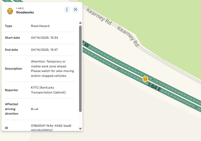
KYTC’s Safety Report Table that notates where mobile work zones in the field are located. From January 1, 2025 to April 15, 2025, 84,884 records were counted.
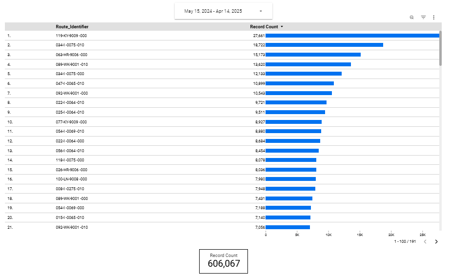
A screenshot of KYTC’s system that displays record counts by route. Their team uses this dashboard to track total reports and monitor their mobile work zone safety program’s effectiveness.
Next steps for the mobile work zone safety initiative
The organization plans to integrate the system with additional traffic management platforms and extend coverage to a broader range of work vehicle types. Furthermore, KYTC aims to explore predictive analytics to improve safety measures further. A key focus is the expansion to secondary roads, which will require developing tailored logic to address the unique challenges of less trafficked areas, particularly regarding speed comparisons.
KYTC continues to consider the broader applications of their solution, including improving emergency service response times. The organization is also developing plans for nationwide implementation and exploring potential international partnerships.
Technological advancements play a crucial role
The organization intends to collect user feedback, investigate AI and machine learning applications, and integrate the system with navigation apps and connected vehicle technology. Additionally, KYTC recognizes the importance of public engagement and plans to launch awareness campaigns, create educational materials and partner with driving schools to promote work zone safety.
Be part of the solution for safer roads
The success of KYTC's approach should serve as an inspiration and blueprint for other transportation agencies facing similar challenges. We encourage other agencies to:
- Evaluate their existing technological infrastructure for untapped potential
- Collaborate across departments to develop innovative solutions
- Prioritize proactive safety measures, especially for unpredictable work environments
- Share best practices and lessons learned to collectively improve road safety nationwide
“Every life lost in a work zone is one too many. Buckle up, put the phone down, and stay alert – our workers' families are counting on you.”- Randi Feltner, Assistant Director, Division of Maintenance, Kentucky Transportation Cabinet
Following KYTC's lead and embracing technology-driven solutions, we can work together to make our roads safer for everyone, one work zone at a time.
About Geotab
Geotab partners with the public sector to provide secure, connected fleet management solutions that you can rely on to drive efficiency and cost savings. For the fourth year in a row, ABI Research has ranked Geotab the #1 Global Telematics Vendor. Our web-based analytics, open platform and Marketplace help our customers optimize fleet performance and unlock insights to improve safety, utilization, maintenance, fuel management and sustainability.
At Geotab, we understand the complexities of managing public sector fleets. We're not just a technology provider; we're a dedicated partner firmly committed to your success.
To learn more about what Geotab can do for your public works department, talk to us to set up a free 1:1 consultation.
Frequently Asked Questions
Table of Contents
Client profile
Client name:
Kentucky Transportation Cabinet
Industry:
Department of Transportation
Fleet size:
6000+
Fleet focus:
Client profile
Client name:
Kentucky Transportation Cabinet
Industry:
Department of Transportation
Fleet size:
6000+
Fleet focus:
Other stories
How Swift Ride saved over $400,000 and eliminated vehicle theft with Geotab
March 25, 2026
4 minute read
Miami Gardens saves $60,000+ annually and generates $1.1M with Geotab
November 4, 2025
3 minute read

King Township cuts winter material use 30% per storm with Geotab
September 24, 2025
5 minute read