Police fleet telematics: How Utah rightsized 60 vehicles with Geotab
Utah's Department of Corrections used Geotab telematics across 1,400 vehicles to rightsize its fleet by 60 vehicles, strengthen officer safety policies, and build an objective record for community accountability.
Published: Oct 2, 2019
Updated: Apr 30, 2026
Success Highlights
- Utah removed 60 vehicles from its 4,700-unit government fleet using Geotab utilization data and IOX integrations to identify underused assets and cut costs.
- Police-specific IOX solutions track emergency lights, sirens, driver ID via NFC badges, and seat belt use to verify real-time policy compliance across law enforcement fleets.
- Telematics data revealed a 144 mph pursuit speed and systemic seat belt non-compliance, prompting the Department of Corrections to update life-saving safety policies.
- Geotab's objective vehicle data helps fleet managers resolve community complaints and verify protocol adherence during incidents with legally defensible records.
When Dan Black, fleet manager for Utah's Division of Fleet Operations, looked at the state's 4,700-vehicle inventory, ranging from sedans to Class 6/7 trucks, the numbers didn't add up. Departments claimed every vehicle was essential — some for on-campus use, some for special assignments — but mileage data told a different story. Without visibility into how vehicles were actually being used, the fleet was carrying unnecessary weight: vehicles sitting idle while the state paid to maintain, insure, and manage them. Black needed more than reports. He needed ground truth.
The challenge: 4,700 vehicles, no reliable visibility
Managing a government fleet means answering to multiple stakeholders — department heads, state officials, and ultimately, taxpayers. For Utah's Department of Administrative Services, that accountability gap had real consequences.
Utah's state faced specific gaps:
Vehicle utilization was self-reported. Departments resisted any vehicle reductions, even for low-mileage units. "We felt that a lot of our fleet was bloated," says Black.
The Department of Corrections (Utah's police fleet) had additional needs: tracking on-duty vs. off-duty vehicle use, monitoring first responder driving behavior, verifying proper use of emergency equipment, and maintaining a historical record of vehicle activity to address community complaints.
Without connected data, there was no objective way to challenge those assumptions or make evidence-based policy decisions.
The solution: one platform, full police fleet visibility
In January 2017, Utah adopted Geotab after an extensive evaluation. Telematics tracking devices were installed in approximately 1,400 of the state's 4,700 vehicles — selected for MyGeotab's comprehensive reporting, ease of installation, and deep integration options for emergency lights, sirens, and other law enforcement equipment
"Number one, it had everything that we wanted in reporting — all the different vehicle functions. It was easy to pull data and have it formatted into an Excel sheet. We could download exactly what data we wanted. Ease of install was a big part of it too." — Dan Black
The Department of Corrections deployed four core capabilities:
1. Fleet utilization reporting via MyGeotab
With MyGeotab, the State of Utah can gather critical data on vehicle utilization: Real-time and historical data on odometer mileage, engine hours, on-duty vs. off-duty use, and time spent in pursuit mode. The data surfaces what departments can't self-report accurately.
2. Driver ID with NFC Technology (IOX-NFCREADER)
Officers scan their badge or ID upon entering a vehicle. Every trip is attributed to a specific officer — creating an individual accountability record without administrative overhead.
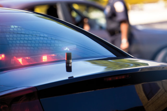
3. Lights and siren monitoring (IOX-AUXM)
Geotab's Input-Output Expander easily connects to the vehicle's 12-volt output and tracks emergency lights on/off, siren on/off, driver's door open, and firearm locker open. Data flows directly into MyGeotab for reporting and rule-setting. Up to four digital inputs are supported.
Geotab’s IOX integrations make it possible to break down utilization even further, showing time spent with the siren and light bar on versus time parked or patrolling. “Geotab makes it so much easier to see in reality what's going on instead of just having someone tell you what is happening with the vehicle,” says Black.
4. Seat belt tracking with custom rules
MyGeotab monitors seat belt use in real time. Utah built a custom rule linking seat belt compliance to vehicle speed and pursuit mode — creating a nuanced, policy-aligned alert rather than a blanket trigger.
"Geotab makes it so much easier to see in reality what's going on instead of just having someone tell you what's happening with the vehicle." — Dan Black
The results: 60 vehicles removed, costs reduced, fleet rightsized
- Geotab data gave the evidence to do what verbal conversations couldn't: challenge unsupported vehicle claims and present a budget saving for other important expenses.
- 60 vehicles removed from service since 2017 — campus units confirmed as underutilized and reassigned or replaced with short-term rental arrangements.
- Fleet bloat quantified, not just suspected — specific departments could now see utilization data for their own vehicles, making conversations about reductions data-driven rather than adversarial.
- Maintenance patterns explained — data revealed why campus vehicles were experiencing unusual tire wear, leading to targeted driver training rather than ongoing repair costs.
- As more Utah state departments adopt Geotab voluntarily — from the Department of Human Services to the Utah State Tax Commission — rightsizing efforts continue to scale without requiring top-down mandates.
Results at a glance:
| Total state fleet | 4,700 vehicles |
| Geotab devices deployed | ~1,400 vehicles |
| Fleet reduction achieved | 60 vehicles removed since 2017 |
| Key integrations | IOX-NFCREADER (Driver ID), IOX-AUXM (lights/siren), seat belt tracking |
| Adoption model | Voluntary — agencies opt in |
Safety and community accountability: data that changes policy
The Department of Corrections found the most consequential results not in the budget, but in officer safety and public trust. Monitoring vehicle speed and the use of auxiliary equipment such as lights and siren shows whether policy is being followed in the field, and whether changes are needed.
- Pursuit speed policy — Geotab data surfaced a recorded pursuit speed of 144 mph. Initially disputed, the vehicle was independently tested and confirmed capable of exceeding 150 mph. The data held. Based on what Geotab captured, the department established formal pursuit speed thresholds — policies Black says will likely save officers' lives.
"They were able to go back and make policies that will probably save the officers' lives." — Dan Black
- Seat belt policy reversal — Officers had historically been trained not to wear seat belts in case rapid exit was required. MyGeotab data revealed a systemic pattern of seat belt non-compliance. The department reviewed the data, weighed the risk, and changed policy: officers must wear seat belts at all times except during low-speed pursuit situations under 5 mph.
- Community complaint resolution — When a community member reports an officer for failing to use lights and siren properly, fleet management pulls the vehicle's historical activity log from MyGeotab. The record is objective and legally defensible.
"Now we have a way of saying, 'Yes, the lights and siren were active when the event occurred.' So, if you didn't yield to a law enforcement vehicle, you are at fault in the State of Utah." — Dan Black
The benefits of Geotab have been far more extensive than the Department of Corrections had first anticipated, according to Black. The fleet manager highlights Geotab as a remarkable product for the public organization.
What comes next: satellite panic buttons and statewide reach
Utah is currently testing a panic button integration using Iridium satellite technology. When activated, it transmits the officer's exact GPS coordinates along with vehicle fault codes — ensuring officers can call for help even without cell coverage, in remote mountain terrain or dead zones.
"There are a lot of departments that are interested in the Iridium satellite panic button. They were stuck there for hours. We've had people stuck for days on the mountain trying to get down." — Dan Black
Utah state agencies aren’t required to use the Geotab device; it’s completely voluntary, but the user agencies that are using it range from the Department of Human Services to the Department of Administrative Services to the Utah State Library to the Department of Corrections.
Black's longer-term goal: legislative action requiring telematics in every state-operated vehicle — not as a surveillance tool, but as standard infrastructure for accountability, safety, and fiscal responsibility.
Perhaps one of the biggest benefits is the flexibility Geotab and its auxiliary functions bring to the state’s fleet and the departments it serves.“And that's why Geotab is so great,” says Mr. Black.
"Geotab gives us a clear picture to better understand cost-saving measures, and make smart decisions based on what our needs are." — Dan Black, Fleet Manager, Department of Administrative Services, Division of Fleet Operations
Frequently Asked Questions
Police fleet telematics provides objective utilization data that reveals which vehicles are underused or idle, enabling evidence-based fleet rightsizing. Utah's Department of Corrections used Geotab's telematics across 1,400 vehicles to identify and remove 60 underutilized vehicles from their fleet, eliminating unnecessary maintenance, insurance, and management costs while maintaining operational effectiveness.
Geotab offers police-specific IOX integrations including driver ID via NFC badge readers, lights and siren monitoring through auxiliary input expanders, and seat belt tracking with custom rules. These features enable fleet managers to verify policy compliance in real time, track on-duty versus off-duty vehicle use, and maintain objective records of emergency equipment usage during incidents.
Telematics data reveals gaps between policies and actual field practices, enabling life-saving policy changes. Utah's Department of Corrections used Geotab data to establish formal pursuit speed thresholds after discovering vehicles reaching 144 mph, and reversed their seat belt policy to require officers to wear seat belts except during low-speed pursuits, addressing systemic non-compliance patterns revealed through tracking.
Yes, telematics provides an objective, legally defensible record of vehicle activity that fleet managers can reference when addressing community concerns. When Utah residents report officers for improper use of lights and sirens, fleet managers can pull historical activity logs from MyGeotab to verify whether emergency equipment was activated during the reported incident, resolving complaints with factual data rather than subjective accounts.
Table of Contents
Client profile
Client name:
State of Utah Police Fleet
Industry:
Government
Fleet size:
4700
Client profile
Client name:
State of Utah Police Fleet
Industry:
Government
Fleet size:
4700
Other stories
Swift Ride Eliminates Fleet Theft and Saves Over $400K Annually with Geotab
March 25, 2026
1 minute read
City of Miami Gardens: Cutting costs, saving lives with Smart Fleet Management
November 4, 2025
3 minute read
Kentucky Transportation Cabinet: Revolutionizing mobile work zone safety
August 6, 2025
6 minute read
How White Cap reduced aggressive driving by 62% and speeding by 97% with Geotab telematics
July 25, 2025
2 minute read