What’s new in MyGeotab — Version 2102
Welcome to our latest summary of updates in MyGeotab.
Jan 10, 2022

Geotab Users: To verify your version: go to MyGeotab > Administration > About, and check the build number, (e.g. 5.7.2102.xxx release).
Resellers: Review this post for important changes affecting your customers and note any recommendations. If you have suggestions for improvement, please leave a comment below.
Sign up for Geotab news
Stay up-to-date on what’s new. Please subscribe to get these posts emailed to you, along with the monthly newsletter.
✱ NOTE: The images shown here are for illustration purposes only, and may appear different in the software as we approach the final release.
New MyGeotab design
New and improved MyGeotab design
If you didn't have Feature Preview enabled, MyGeotab might look a little different for this release. As announced in our 2101 roll out, our Product and Design teams have been working hard to maximize functionality, encourage exploration, and simplify your experience with a new and improved look. We're keeping it simple with clean text, added contrast, and neatly arranged elements. Navigation is more intuitive, and user actions more distinct. Customers like it so much we’re taking it out of Feature Preview! For this release, the new design will be applied by default.
✱ NOTE: To get the most out of the new design, be sure to update any documentation, screenshots or training material as soon as possible.
Are you an Add-In developer? Please review the new design specifications for icons to ensure they align with the design changes in this release.
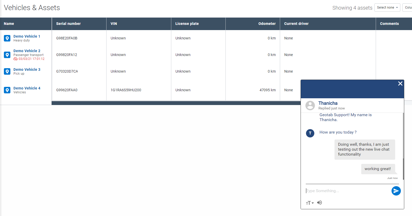
Live chat
MyGeotab now supports Live Chat
Need help fast? Ask questions and get answers with our new Live Chat feature, now available under Getting Started & Help > Support > Live chat with Agent. We're keeping it personal by starting a conversation that helps us get to know our users — and you, to get to know our products. Simply tell us who you are, what you need help with, and our Agents are standing by to help you stay connected and stay on the road.
✱ NOTE: To use the Live Chat feature, your username must be an email address.
Dashboard
New and improved built-in dashboard reports
We've removed our current suite of built-in reports, and replaced them with new, contemporary reports that make sense for your business. The following reports are enabled by default, immediately after registering a new database.
- Idling violations
- Watchdog
- Fleet utilization
- Fleet distance trend
Added 17 brand-new reports
We have added 17 brand new built-in reports to each and every Customer database:
- Active engine faults
- Aggressive driving
- Idling violations
- Possible collisions
- Average fuel economy
- Driver safety scorecard
- Speeding violations
- Seat belt violations
- Max speed
- Fleet distance trend
- Asset utilization
- Fleet utilization
- ELD unidentified driver logs
- ELD diagnostics and malfunctions
- ELD unverified logs
- HOS violation breakdown
- Unrepaired defects
✱ NOTE: Except for the Idling violations, Watchdog, Fleet Utilization, Fleet Distance Trend, and all other reports are not enabled by default. Users can navigate to the Built-in reports section on the Report Setup page to set up these and other reports. Options include Dashboard and Email reports as well.
Updated report templates
We've updated all 65+ of our built-in reports to better showcase our system capabilities, and to improve layout and visual appeal.
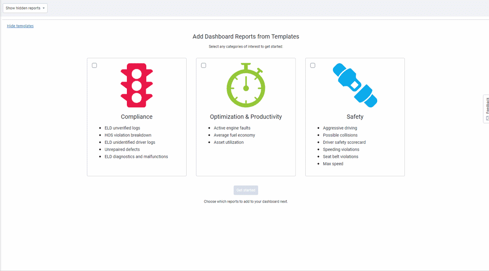
Dashboard wizard (Feature Preview)
Whether you're a new Customer looking to hit the ground running, or an existing Customer looking to improve fleet operations, our new Dashboard wizard can help you get started in three easy steps. Simply choose your pillar of interest, select your reports, and choose your audience. We’ll do the rest. Rules are applied automatically, and can be changed any time by going to Administration > Report Setup > Dashboard.
✱ NOTE: Only users with Company Group access, and the appropriate permissions to set up reports can view the Dashboard wizard.
Reporting
Faster reports, ready when you need them
To support large fleets and date ranges, we've added functionality to improve the performance of our Risk Management and Exceptions Summary reports. Faster run time means faster access to information.
Map
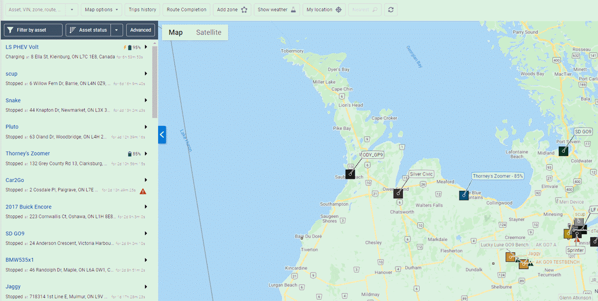
Live Map advanced view (Feature preview)
Fleet owners can now view asset details while tracking their position on the Live Map. This is helpful for fleets who want to monitor the current status of their assets, e.g. temperature, loaded state, fuel level, and more.
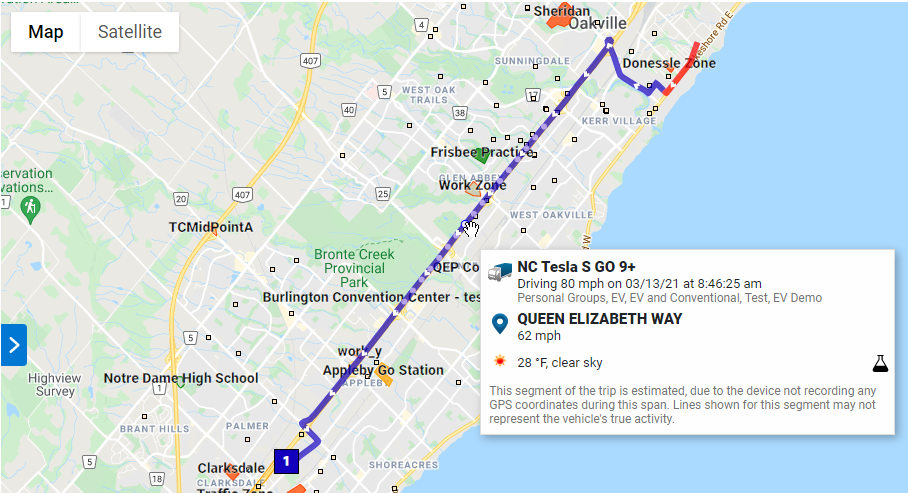
Snap to road
To better visualize trips on the Map, we've integrated our routing service with tools to support all types of devices. Fleets with telematics devices that record less frequently will find this feature helpful as trip data will no longer interfere with landmarks on the Map.
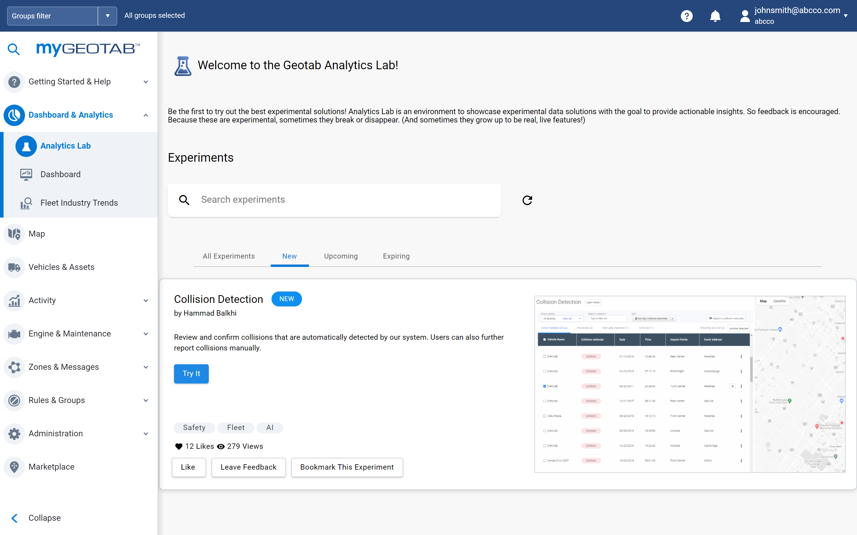
Analytics Lab
Analytics lab is now available for all Customers!
In our last release, we introduced the Marketplace Analytics Lab Add-In, a suite of experimental Apps designed to provide performance insights that help fleets make informed business decisions. For this release, the Analytics Lab is installed by default, and available to all MyGeotab users — except for white-labelled and FedRAMP Customers. Using fleet telematics data, the Analytics Lab combines easy-to-use Apps with templates and models from our own API Explorer to analyze, visualize, and uncover trends in your fleet’s operations. We have a number of experiments available, but are always improving, or adding more. Keep checking back to see if there is one that interests you!
✱ NOTE: To view the Analytics Lab page, users must have the View Analytics Lab security identifier, and must have access to all devices on the page.
Feature name changes
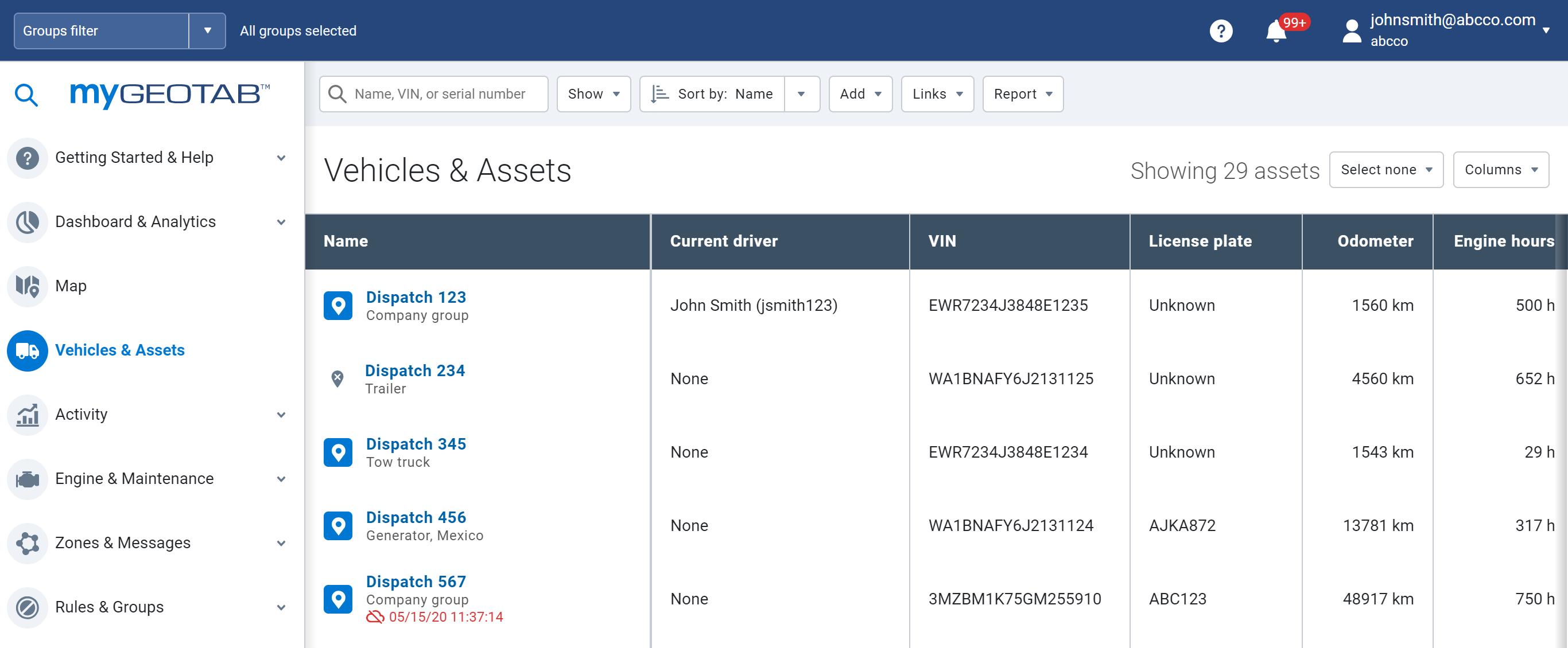
Renamed Vehicles to Vehicles & Assets
Telematics isn't just for vehicles anymore, and neither are we. MyGeotab is a full-service IoT platform that can connect to any asset, including trailers, generators, and other industry equipment. To better reflect our data acquisition capabilities, we've changed Vehicles to Vehicles & Assets in the main menu, and vehicles to assets throughout the application.
✱ NOTE: Compliance-related features such as Hours of Service (HOS) and inspection reports will continue to use the term vehicle.
Renamed DVIR to Asset Inspection
We’re growing! To support our international Customers, we're changing the name DVIR to Asset Inspection to better associate features with functionality.
Assets
Device replacement messages
Need to replace your devices? Ready for the 3G sunset? Replacing your devices just got easier. We've added two new tools to the Assets page to tell you when to replace your devices, and how to request the replacements from your Reseller.
Users
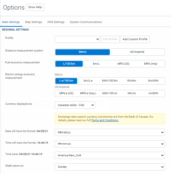
New currency feature
We've introduced currency support into our Maintenance Reminders and now, users can select their regional currency for all cost-related items, across the application, from the Options page. For fleets that frequently cross borders, the application also supports multi-currency conversions.
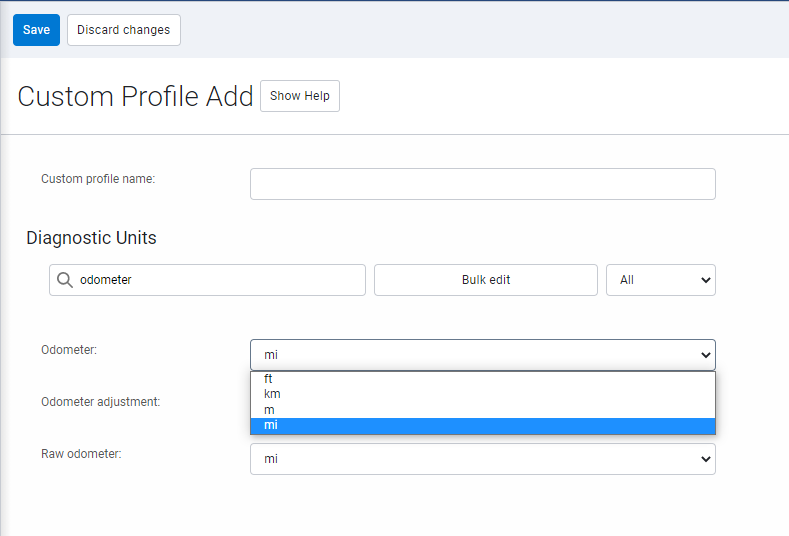
New profile setting
Users can now select their regional unit of measurement for units displayed on the Engine Measurements page, from the Options page. Users can also create custom profiles if there are no suitable defaults to choose from.
✱ NOTE: This feature will be available across the application, including reports, in a future release.
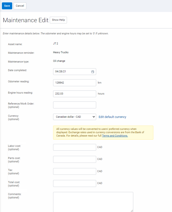
Maintenance reminders
Log maintenance costs
Users can now record the cost of asset maintenance on the Maintenance Event page. For a detailed analysis, costs can be broken down into parts, labor and tax. This feature also supports multi-currency conversions and the option to select a default regional currency.
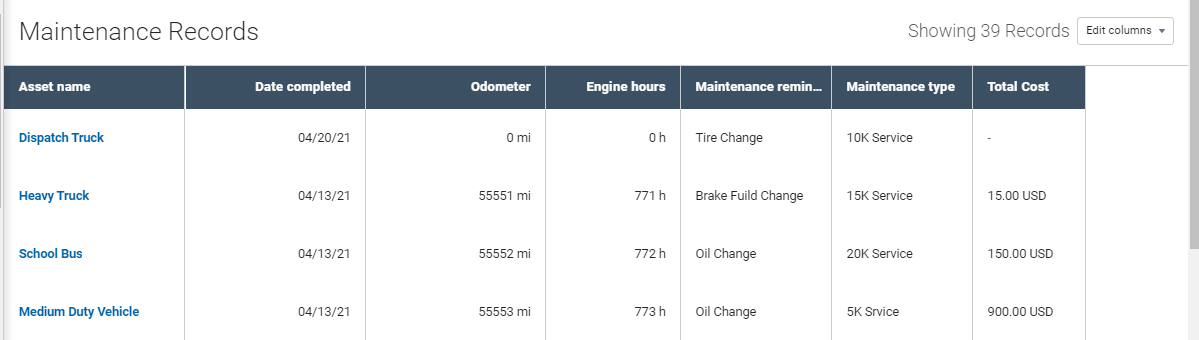
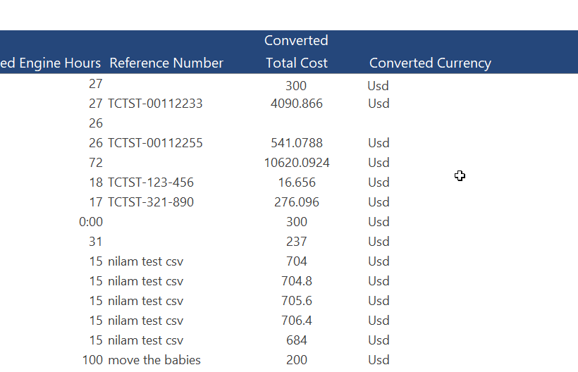
New Maintenance cost columns in reports and bulk import template
We've added new columns to the Data and Summary report tabs for total asset maintenance costs. Users can also import asset maintenance costs from the bulk import template.

New date picker options for upcoming maintenance
For fast access to upcoming maintenance events, we’ve added options for Next Week and Next Month in the date picker.

Excel® file support for importing bulk maintenance records
Users can easily import maintenance records into an Excel spreadsheet in both .CSV and .XLSX formats.
General Bug Fix
General bug fixes for UI and user experience improvements.
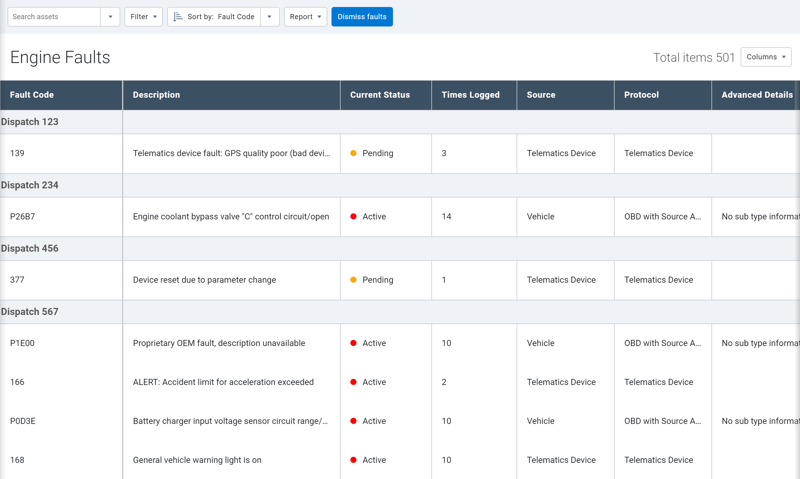
Engine Faults
Redesigned Engine Faults page
The Engine Faults page has been enhanced, and now includes the following:
- Compact table layout.
- Ability to view/hide columns.
- Filter options for source (vehicle or telematics) and/or protocol.
- Total number of times a fault was logged.
- View options for Fault Code, Description, Current Status and more.
New filters for Engine Faults reports
Added new filter options to Engine Fault Reports. Options are also available for Dashboard and Email Reports. Faults can be filtered by:
- Source of fault (vehicle/telematics).
- Engine protocol.
- Engine diagnostic.

Public works
New Public Works Route Completion Reports (Feature Preview)
To ensure valuable infrastructure is serviced adequately while controlling costs and tracking material usage, the Route Completion features are now available to Geotab Public Works users. Government agencies who manage assets such as salt spreaders, snow plows, street sweepers, and waste management assets will find this feature useful for complying with maintenance and service standards.
Be sure to enable Feature Preview, and visit the System Settings page, where you can import your routes. Once imported, return to the Map and press the Route Completion button at the top.
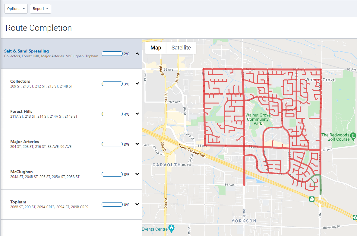
We’ve also added two new built-in reports: Standard and Advanced Route Completion Reports.
Ability to upload Shapefile for Route Completion (Feature Preview)
Routes can now be uploaded to MyGeotab using Shapefile Upload under System Settings > Route Completion.
.png)
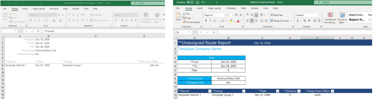
New Route-based option for material management report (Feature preview)
Material Management Reports can now be generated for any Route Completion routes that are uploaded. This new report provides detailed and summary totals for Winter Operation materials (solid, pre-Wet, anti-ice), and operations activities (spread time, plow distance), per service group, route group, and routes.
.png)
Language
New language support
Added language support for Czech and Swedish.
MyGeotab security identifiers
Added the following security identifiers in MyGeotab
- View route completion reports: Allows a user to view Public Works Route Completion Reports.
- Administer device share: Allows a database user to extend their telematics services to another database.
- View device share: Allows a user to view telematics services extended to their database from another database.
- Administer user device link: Allows a user to create a link between a user and a device. (API only).
- View user device link: Allows a user to view existing links between users and devices (API only).
- View analytics lab experiments: Allows a user to view the Analytics Lab menu under Dashboard & Analytics.
General improvements
- Implemented bug fixes and added new translations
- Increased the area activity search to 72 hours from 24 hours
- Updated the page that follows the Login to get started button that users click via email after registering a database to be the Add Asset page
- Added a select all in filter option on the Zones page for bulk editing
- Added a checkmark to indicate the status of a message (sent, delivered, read)
- Added phone number and website to the System Settings feature
- Added the ability to reject new installation records
MyGeotab SDK and Add-In updates
Data Intake Gateway (DIG)
DIG is our new platform for integrating custom telematics data into MyGeotab. To learn more, click here.
APIv1 JSON Serialization
To reduce the duration of process-intensive requests with large JSON payloads, the MyGeotab JSON-RPC API now uses System.Text.Json instead of Newtonsoft.JSON to serialize JSON data sent using the API. This change includes backward compatibility with Newtonsoft.JSON, with the following exception: Numbers with decimals will no longer be serialized using the decimal followed by a zero, if it is a whole number.
Nuget Package
The Nuget Package now targets .NET Standard 2.0,.NET Standard 2.1 and .NET 5.0. To improve serialization and deserialization performance, the Geotab.Checkmate.Objectmodel Nuget Package version 5.7.2102 replaced the JSON serialization library from Newtonsoft.JSON, with System.Text.Json.
✱ NOTE: Due to the performance improvement with System.Text.Json, the existing rate limit OverLimitException may be surpassed when calling the GetFeed API in a tight loop.
SDK Site
SDK site adjusted for AODA compliance.
Generator Add-in
New Geotab Drive Add-in features start/stop, hook and notifications added to generator-addin.
General SDK updates
DeviceSearch
Keywords property expanded to include EngineVehicleIdentificationNumber, VehicleIdentificationNumber and SerialNumber properties.
DeviceShare, DeviceShareSearch, DeviceShareType, DeviceShareSearch
Beta support for DeviceShare functionality added. This object is used for Extendable Services billing purposes.
DutyStatusLogType
Added Work, Rest, and WorkExemption properties.
ExceptionRuleBaseType.cs
Route Completion displays the completion status of custom routes and roads to help users maintain compliance with service level agreements. A route is completed based on the rule and conditions set by the user. Route completion exceptions represent servicing activity for a set of previously defined routes, within a service group.
A new “RouteCompletion” category is used to classify a rule in the Route Completion Report. Route completion rules are returned with unfiltered requests to the Get<Rule> API, or with the category filter "UserExceptionRules". They can also be searched by "RouteCompletion".
FaultData
Added FaultStates. This allows faults to represent more precise and potentially multiple fault states. In the future, FaultState will be deprecated, though still available for backwards compatibility.
FaultState
Removed PendingOff, ActiveOff, InactiveOff, as more accurately represented in FaultStatus.
FaultStateProvider
Describes the current FaultState when a single fault is present.
FaultStatus
Complements the FaultStates property of FaultData. Describes the status of a fault.
GetFeed<TextMessage>
To comply with the GetFeed contract and avoid performance loss, fixed a bug that applies both fromDate and fromVersion when both are supplied in the API request. When fromVersion is supplied, fromVersion will be ignored.
✱ NOTE: This fix may return more records when both fromDate and fromVersion are supplied with before the given dateTime is returned.
Also, fixed a bug where toVersion is returned as 0, when a search returns no results. Now, when no results are returned, ToVersion is returned as the latest Feed version.
HosRuleSet
Added StandardHoursSoloExemptionHours.
RoutePlanItem
Added PassCount. The expected number of passes through the Zone.
RouteSearch
Added Groups search option to allow searches for Route Completion routes (RouteType.Service) that are members of GroupSearch(s). Only returns routes that are members of a service group hierarchy.
RouteType
Added Service route type.
SecurityIdentifier
Added RouteCompletionReport.
UserSearch
Added UserSearchType property to address IsDriver search limitation for Driver or Drivers, and Users. UserSearch allows searching for drivers and users, users who are not drivers, and only users who are drivers. IsDriver will be deprecated but remain backwards compatible.
UserSearchType
Added values to the UserSearch, UserSearchType properties.
Contributors:
Vik Sridhar, Senior Product Manager, Heather Holmes, Senior Technical Writer, Julia Nowaczyk Merker, Technical Writer, Inshaal Badar, Senior Content Specialist
Subscribe to get industry tips and insights
The MyGeotab and Technical Writing Teams write about MyGeotab updates for Geotab.
Table of Contents
Subscribe to get industry tips and insights
Related posts

The plug-and-play rental fleet: Upgrade your technology without missing a single booking
April 27, 2026
5 minute read

The Evolution of Product Updates: Welcome to Your New Centralized Hub
December 15, 2025
2 minute read