Map yourself in OpenStreetMap
OpenStreetMap is rapidly expanding.
By Geotab
Mar 8, 2023

OpenStreetMap (OSM) is an online map of the world that “creates and distributes free geographic data for the world.” (http://wiki.openstreetmap.org/wiki/Main_Page) Since its early days, starting in 2004, its reach has quickly spread to the most remote areas of the globe – due to the development of web-mapping and the concept of crowdsourcing.
Crowdsourcing is when community participants volunteer their efforts by adding relatively small pieces into a shared, publicly available product. And despite its name, the OpenStreetMap contains street network data and other useful information, such as speed limits, points of interest, land features (rivers, lakes), and more. It is impressively accurate, especially in areas dense with contributors.
Check this out for yourself:
- Open the map and navigate to an area you know well. Is everything correct? Look at the road names, house numbers, land features and points of interest. If you notice something that doesn’t look correct, you can easily become an OSM contributor and fix the omissions.
- Whether you live or run a business in a densely populated area or some remote location, you can help yourself and others by contributing to provide free and equal access to high-quality maps and other geographical information.
To illustrate, we picked up an area near Armiel Crt, Toronto, opened it in OSM:
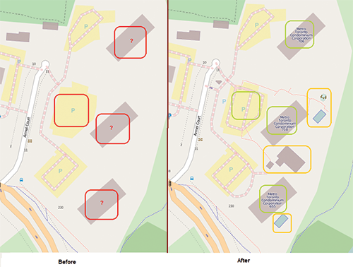
Before
This is the original map view. The items that were missing are highlighted: the driveway at the middle building’s parking lot and the 3 condominium towers’ names and addresses (the addresses are searchable and also visible with “browse map data” option selected).
We took on the challenge to fix this by familiarizing ourselves with the Beginners Guide on OSM maps authoring and after some experimentation, it was done.
After
This is the map after our changes. Note the new features highlighted in green: the driveway and the condominium corporation names.
To our surprise someone else was editing the same area in parallel. Note the yellow ink – bound map features (a playground, a pool, etc) that didn’t exist before we started our project.
Go ahead and try it. You will be glad you did (and others will too)!
Subscribe to get industry tips and insights
Geotab team
Related posts
Beyond consumer apps: 5 ways integrated navigation protects your fleet
July 23, 2026
6 minute read

Closing blind spots in cargo security with a 360 fleet camera system
July 22, 2026
3 minute read
The safest mile in field service is the one nobody drives
July 22, 2026
2 minute read


Crafting a fleet incident management plan that helps your municipality get ahead of claims
July 16, 2026
5 minute read
.jpg)
Marketplace Spotlight: Redefining Fleet Security with Matrix iQ
July 15, 2026
2 minute read