Geotab data shows impact of Hurricane Harvey
Hurricane Harvey continues to have a devastating impact on the lives of Texans. The impact has been felt not only on a personal level by citizens all across the Houston area but economically through the thousands of businesses.

By Mike Branch
Vice President, Data and Analytics at Geotab
Apr 20, 2023

Hurricane Harvey continues to have devastating impact on the lives of Texans. The impact has been felt not only on a personal level by citizens all across the Houston area, but also economically through the thousands of businesses that simply cannot operate as they did just a few days before Harvey hit. There are Geotab devices in thousands of vehicles in the Houston area and we have already seen the economic impact that a disaster like this can have on business operations.
See also: The impact of hurricanes on supply chain and transportation
Monday, August 21, 2017 - Commercial fleet activity before Harvey
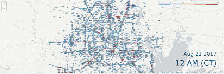
Here’s a 24 hour timelapse of activity on a normal Monday, only one week earlier on August 21. You can see around the early morning hours how the city lights up and major arteries awaken throughout the course of the business day.
Monday, August 28, 2017 - Commercial fleet activity after Harvey
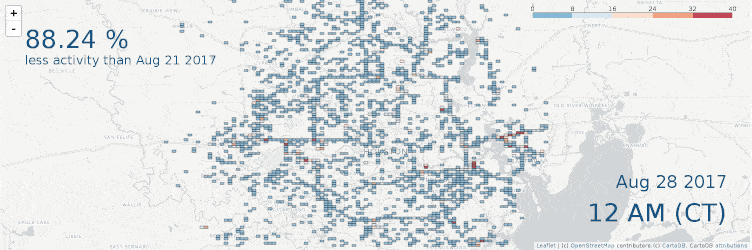
Contrasting the August 21 map to a week later on Monday August 28, the effects of Harvey have truly hit home. The city does not light up. Its downtown core and arteries are ghosts of what they were a week before (specifically around highway 8 and 610 which loop around the city where the major roadways flooded). There is an 88% reduction in commercial fleet activity in the Houston area, translating into severe economic losses and downtime.
Monday, September 04, 2017 - Commercial fleet activity after Harvey
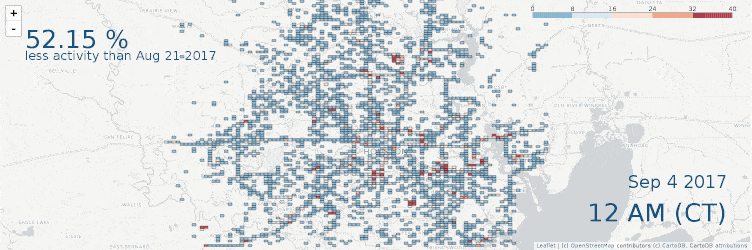
On September 4, a significant improvement in commercial fleet activity from the previous week can be seen, despite being a national holiday. While back on Monday, August 28, an 88% drop in commercial fleet activity was noted, the following week on September 4, that difference had fallen to a 52% drop as compared to the baseline on August 21. There is still a long road ahead, but we are beginning to see a noticeable return in commercial fleet activity in the Houston area.
Monday, September 11, 2017 - Commercial fleet activity after Harvey
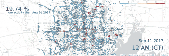
Based on the patterns we are seeing in commercial fleet activity throughout the Houston area, it is clear that the city is in the process of recovery now that it has been two weeks since Hurricane Harvey hit. In an effort to restore order during this time, there is an influx of utility vehicles working to restore power, delivery vehicles working to replenish stock and people coming together to rebuild. This week represents the first time that an increase in commercial fleet activity can be seen since the baseline that was taken on August 21. On Monday, September 11, we noted a 19.7% increase in commercial fleet activity over the baseline as is illustrated in the time-lapse map above as fleets continue to work hard to bring Houston back to pre-Harvey conditions.
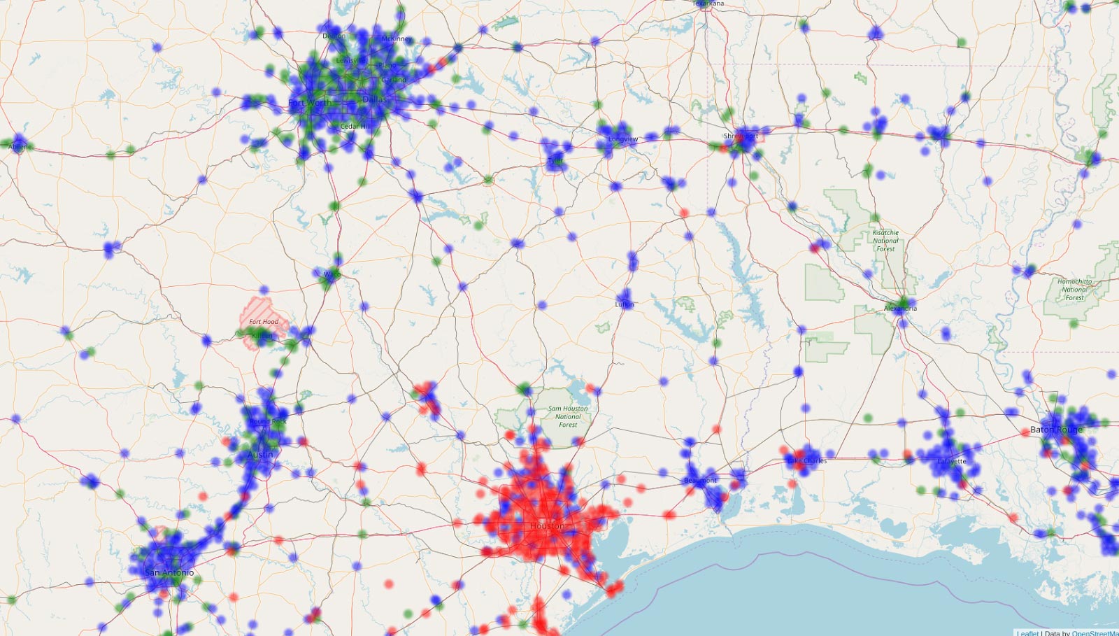
Comparing commercial driving activity
To give you a bigger picture of this impact, we looked at areas in southern Texas where there was significant drop in commercial fleet activity from August 21 to August 28:
- Blue means no real change
- Green indicates an increase of 30% or more in activity
- Red means there was a 30% drop in activity
You can truly see the impact on a grander scale by contrasting Houston to its neighbouring cities.
Safety, community, and aid
While disastrous flooding has caused closures on major roads, frontage lanes and exits during one of the nation’s costliest disasters, Geotab is providing insight to those affected by Hurricane Harvey.
“It is crucial that we do everything possible to help our customers protect the lives and safety of their drivers in the affected areas as we continue to face the outcome of this storm,” said Neil Cawse, Geotab CEO. “Geotab is working closely with our partners to provide relevant data so that commercial and emergency fleets are able to travel safely and respond urgently to the victims of Hurricane Harvey.”
For updated map views on commercial fleet activity in Houston during this crisis, refer back to this blog post each week to view or download our latest timelapse images.
Related:
Geotab data shows massive increase in fleet activity as Florida prepares for Hurricane Irma
Subscribe to get industry tips and insights
Mike Branch
Vice President, Data and Analytics at Geotab
As Geotab’s Vice President of Data and Analytics Mike Branch leads the development for solutions that enable insight from over 5.8 million connected vehicles and 100 billion telematics records that Geotab processes daily.
Table of Contents
- Monday, August 21, 2017 - Commercial fleet activity before Harvey
- Monday, August 28, 2017 - Commercial fleet activity after Harvey
- Monday, September 04, 2017 - Commercial fleet activity after Harvey
- Monday, September 11, 2017 - Commercial fleet activity after Harvey
- Comparing commercial driving activity
- Safety, community, and aid
- Related :
Subscribe to get industry tips and insights
Related posts


B.C.'s Dashcam Mandate Creates an Opportunity for Safer Roads Across Canada
June 5, 2026
2 minute read

B.C.'s new dash cam law: A six-month clock is about to start for commercial fleets
June 2, 2026
5 minute read

Reefer trailer temperature monitoring: How it works, systems, and fleet benefits
May 26, 2026
5 minute read

Fleet Safety Results: Richfords Cuts Speeding and Harsh Driving with Geotab Vitality
May 11, 2026
3 minute read