What’s new in MyGeotab — Version 2101
Welcome to our latest summary of updates in MyGeotab.
Nov 7, 2024
As of October 1st, 2024 Geotab is no longer offering the rate plans of Base, Regulatory, Pro, or ProPlus to new customers in favor of a new streamlined offering of GO Plan. Existing customers will be transitioned. To learn more about the advantages of GO Plan please contact your authorized Geotab Partner Reseller or your Geotab Partner Account Manager.
Geotab Users: To verify your version: go to MyGeotab > Administration > About, and check the build number, (e.g. 5.7.2101.xxx release).
Resellers: Review this post for important changes affecting your customers and note any recommendations.
Sign up for Geotab news
Stay up to date on what’s new. Please subscribe to the Geotab newsletter to get these update posts emailed to you.
✱ NOTE: The images shown here are for illustration purposes only, and may appear different in the software as we approach the final release.
✱ END OF LIFE NOTICE: Please take note, for this release, we will no longer support Internet Explorer 11. This notice follows the Microsoft announcement where they will be ending support for Internet Explorer 11 and older, later this year.
New MyGeotab design
New and improved MyGeotab redesign (Feature Preview)
As announced in the previous release, MyGeotab has a new and improved look! Our product design team has collaborated with our product and development teams to redesign and update the overall look of MyGeotab using industry-best UX practices — currently in Feature Preview.
The new and improved design focuses on drawing the eye to the important areas of the page using simple and clean colors and fonts. The navigation icons have been redesigned to focus on the meaning behind each symbol, and to use color to clearly indicate the currently selected item. Buttons and components have been updated to be more intuitive and to follow modern patterns.
The following components have been redesigned:
- HOS Logs and HOS Availability pages
- Charging events
- Updated logo and favicon to use accessible colors
- Maintenance and Reminder Rule Add/Edit
- Report pages
- User options
- Vehicle Edit page
- User Edit page
✱ NOTE: In the 2102 release, the new and improved MyGeotab redesign will be applied by default (without Feature Preview enabled). The 2102 release will roll out towards the end of May 2021. Please ensure you have updated any documentation, screenshots or training material prior to this date.
Are you an Add-In developer? Please review the new design specifications for icons to ensure the icons align with the design changes in the 2102 release.
Vehicles
Vehicles without serial numbers
You can now add vehicles into MyGeotab without a serial number. Please note the functionality of the feature is limited without the use of a telematics device. The following is a list of use cases for this feature:
- If you know the vehicle in which you plan on installing a telematics device, but don’t have the device yet. You can now add the vehicle into the system and set it up with the appropriate name, groups, license plate, and other information, and add the serial number afterwards.
- You have assets that you want to do inspections against or set maintenance reminders for, but may not have any immediate plans to purchase a telematics device.
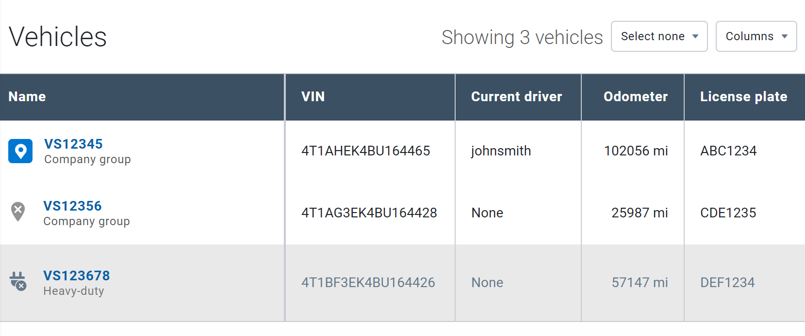
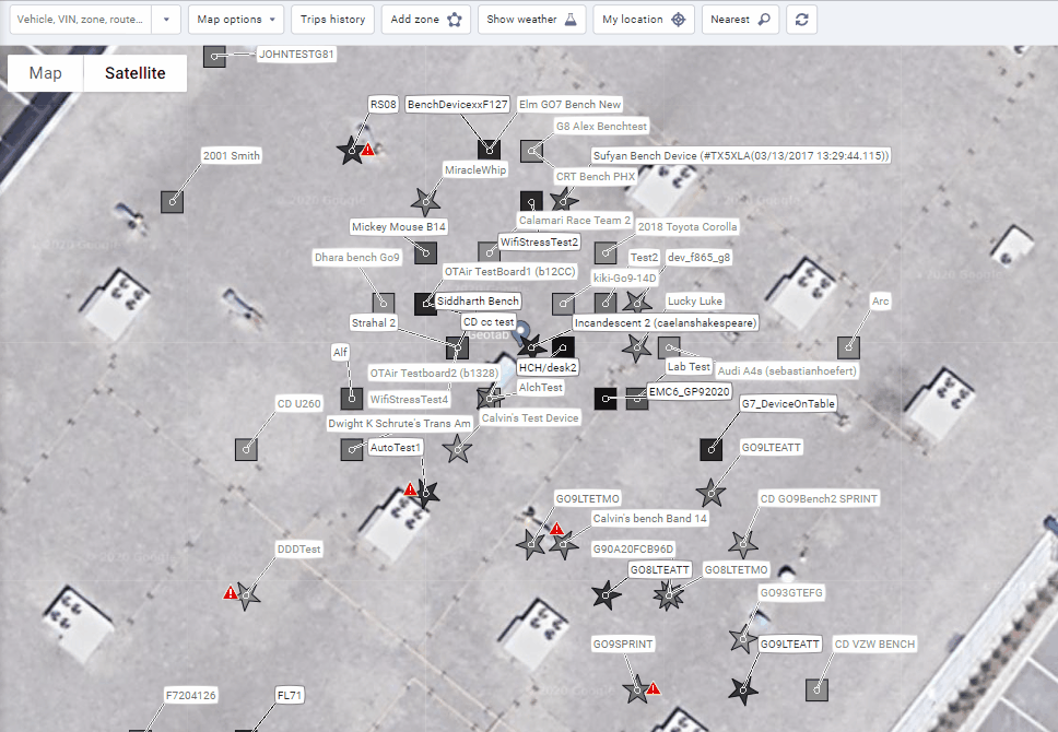
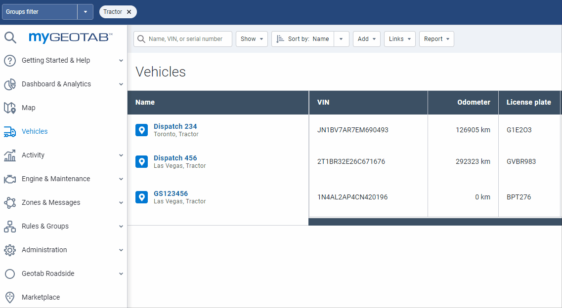
Additionally, there are now three vehicle activity statuses, indicated by icons, displayed on the Vehicles page.
- Active with a tracking device
- Active without a tracking device
- Archived
The image below displays the status icons in the order listed above.
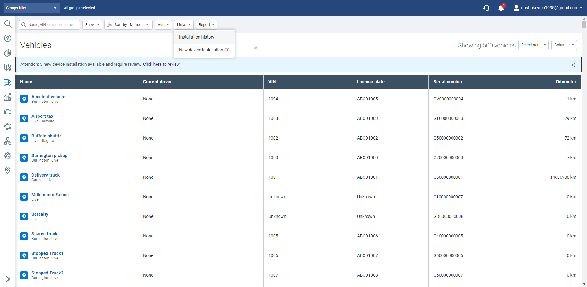
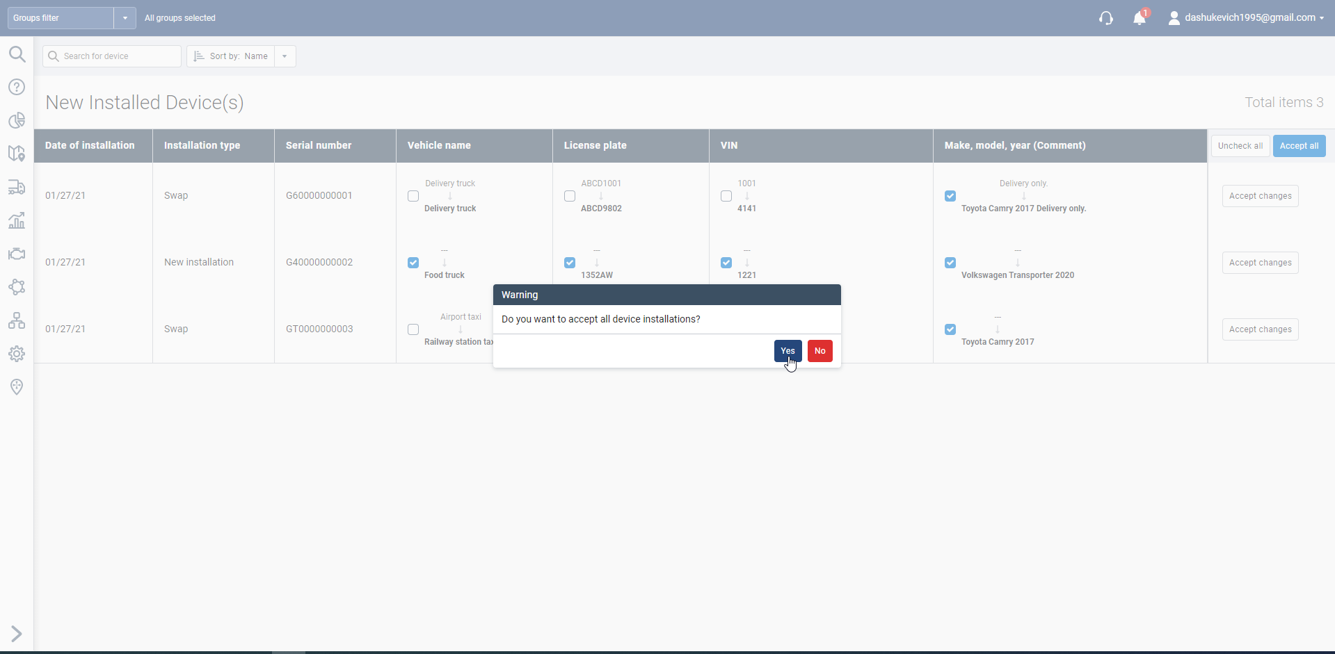
Streamlined process for install records
Previously, Customers who employed Installers and used one of the installation websites (https://myadmin.geotab.com/install.html) had to navigate to a specific page to review new installation records and manually update the vehicle name, license plate and other information. Now, Customers receive a prompt when there are new installation records, and we have streamlined the process so users can update the vehicle information using an Accept all button.
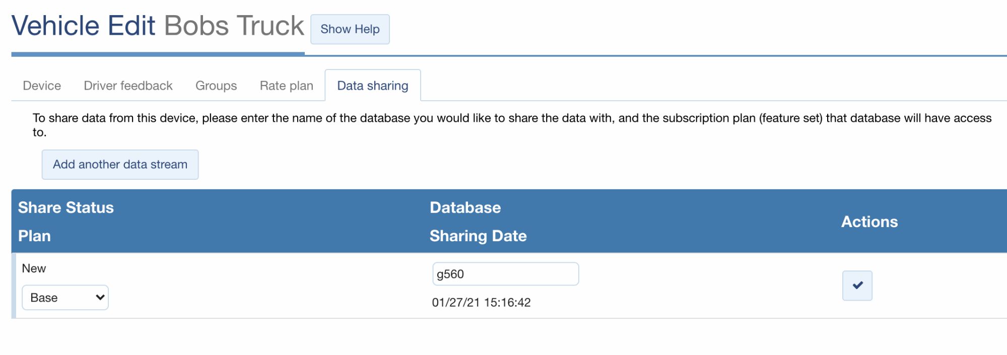
Device Data Streaming
Connect and collaborate with trusted partners and other organizations using our new secure Data Streaming technology! Share performance-driven data with insurance providers to save on coverage costs, or engine diagnostics with maintenance providers to save on repair work. With Data Streaming, Administrators can send share requests to partners they work closely with, and partners can subscribe to Data Streams that make sense for their business. Subscriptions are available on Base, Regulatory, Pro, and ProPlus rate plans, with easy billing that begins as soon as a share request is accepted.
Map
New option to hide vehicle name and driver name
By popular demand, we have added an option for users to hide the vehicle’s name and/or the driver’s name displayed on the MyGeotab map. This is useful for fleets with many vehicles in close proximity, for example a parking lot. You can still hover your mouse to see the name of each vehicle.
Live location button enhancement
For both desktop and mobile, we have enhanced the My location button to now show you where you are on the map with a blue circle. Previously, the map displayed the general area but did not specify the location.
Reporting
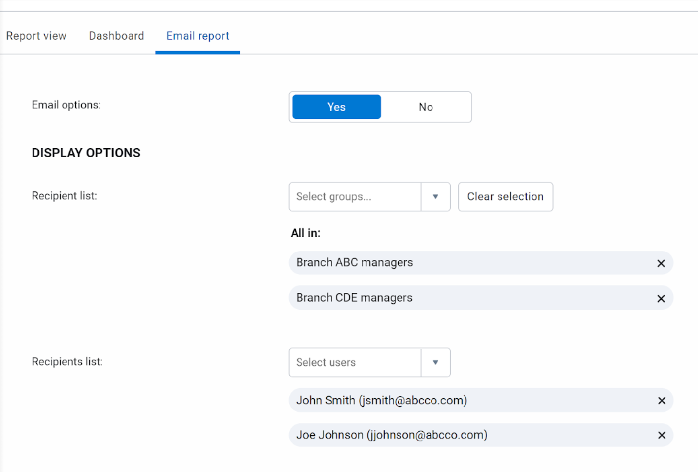
New option to select individuals for reports
By popular demand, we have added an option to specify individual users to be recipients of both dashboard and email reports. Previously, users could only select Groups.
Groups
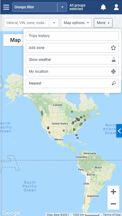
New global groups filter capabilities (Feature Preview)
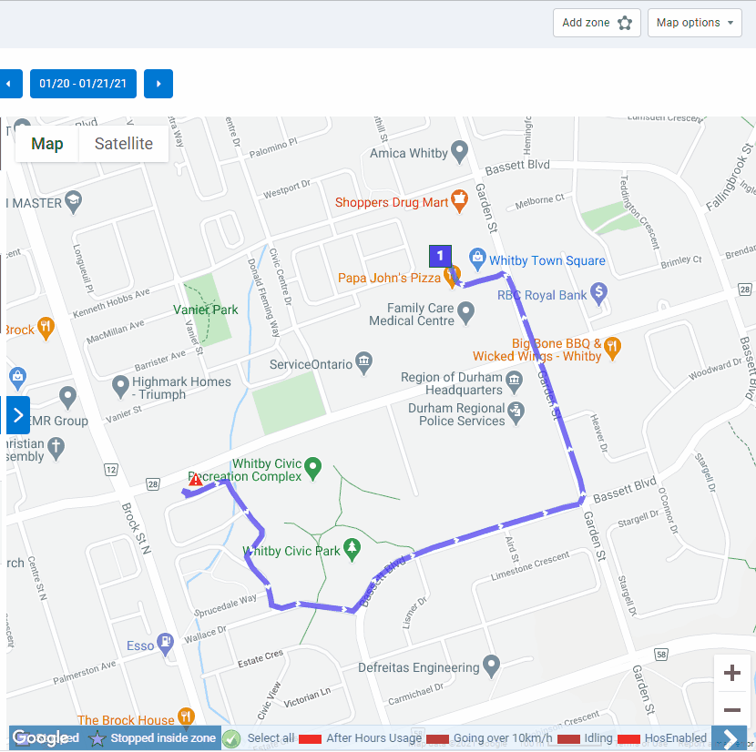
For the Groups filter, you now have the option to specify the type of Operator (AND and OR) to use when searching for groups — available in Feature Preview. The Advanced Groups Filter option allows you to use more than one type of operators when searching for a specific group.
For example, filtering for vehicles that belong to the Tractor group and the Toronto group displays a list of tractors that belong to the Toronto branch. Previously, the Groups filter used the OR operator by default. Using the example above, this means, the page displays all the tractors (including those outside Toronto) and all vehicles in Toronto (including non-tractor vehicles) together.
Trips history
Replay
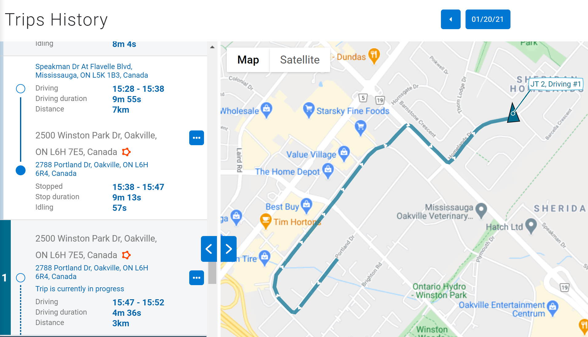
We’re introducing a new Replay feature — located in the Map options dropdown menu. This feature allows you to replay trips for single or multiple vehicles and allows you to better understand how the driver’s trip progressed. For example, you can view parts of the trip where the driver may have experienced delays, where the driver drove at optimal speed, as well as exception events and other insights.
Always see the latest and current trip in progress
On the Map, you can now view the vehicles’ previous trip as well as the vehicles’ current position during a trip in progress at the same time. For example, a fleet involved with winter operations can see the previous trip activity of the snow plows as well as the current location of the snow plow at the same time.
Rules
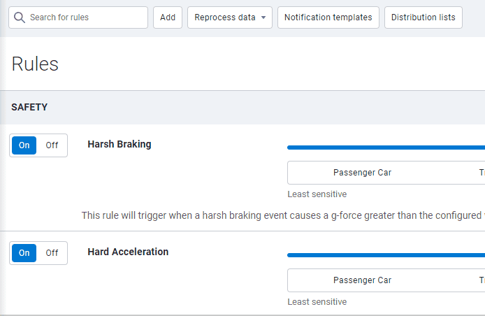
Reprocessing data for select rules only
You can now select specific rules to evaluate when requesting a reprocess of data. Previously, if you wanted to reprocess data for fleet vehicles, the system would evaluate all the rules in your database for the specified time period. Customers have informed us that after a full reprocess of data, genuine exceptions are erased.
For example, an exception event is generated when a driver speeds in a construction zone. Then, later in the year — when the construction is completed — the speed limit reverts to the original posted road speed. In this case, when the data is reprocessed, some exception events are removed since the system now evaluates the rule against the current posted road speed. By selecting specific rules to evaluate when reprocessing data, you can preserve your data and avoid similar situations.
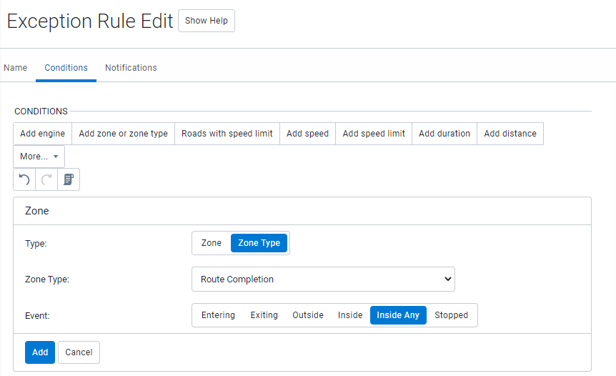
New event type added to Exception Rule Edit page (Feature Preview)
We’ve added a new event type — Inside Any — to the Exception Rule Edit page, available in Feature Preview. With the Inside Any event type, a separate exception event is generated for each zone when a driver drives through a cluster of zones — either overlapping or in close proximity to each other — with the same zone type.
Previously, users were required to create separate rules for each zone within a cluster to achieve this result. For example, generating exception events for 1000 zones in an area would require one rule per zone — resulting in 1000 rules. The Inside Any feature allows the user to categorize the zones as a single zone type, thereby creating one rule that generates exception events for each zone, as required.
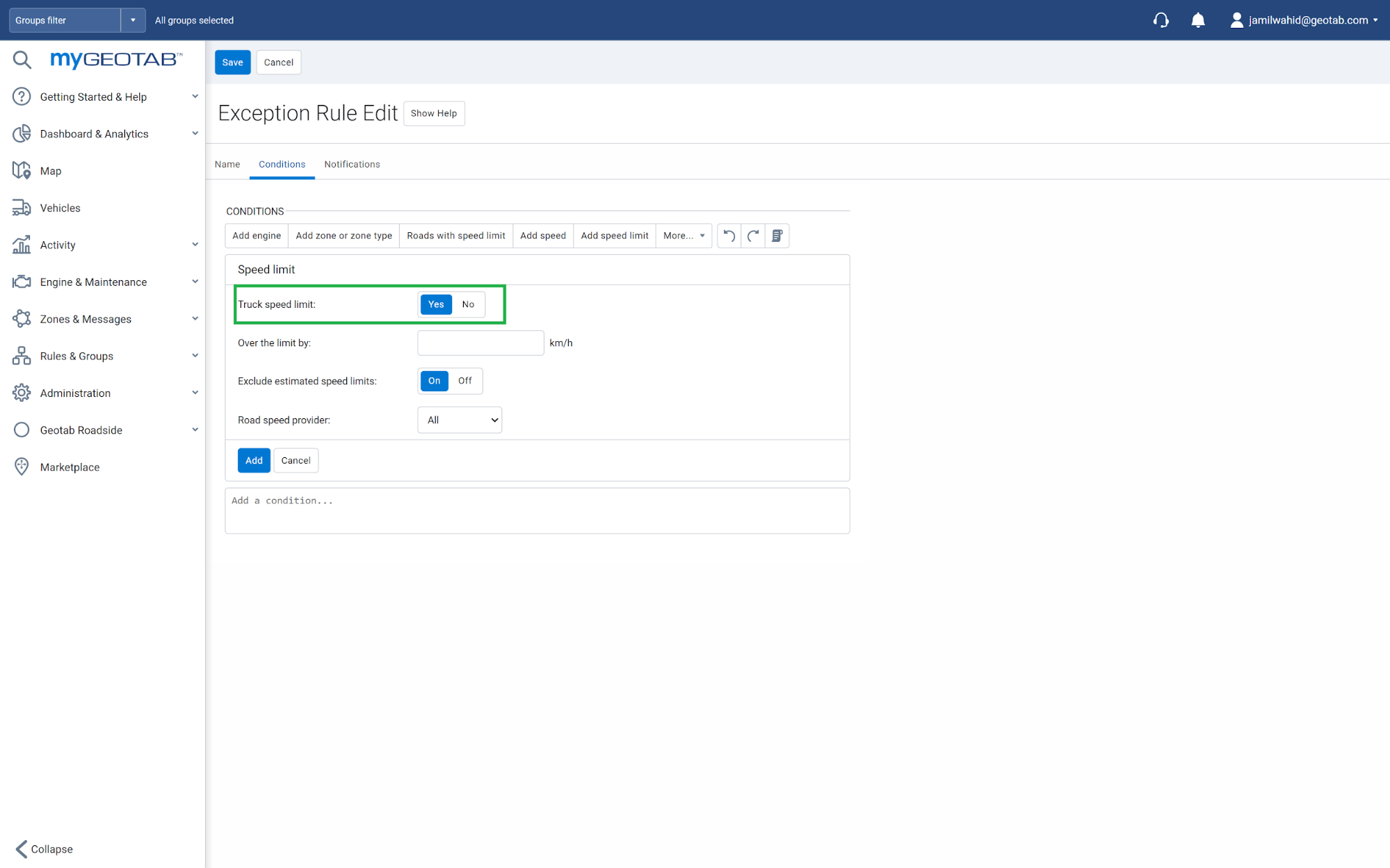
Improved speed limit data for trucks in USA, UK and Australia
Some jurisdictions enforce different speed limits for trucks and passenger vehicles, making it difficult to accurately track speed profiles. To better serve our global users, MyGeotab now allows fleet managers to apply truck-specific speed limits based on posted road signs.
In addition, adding truck speed limits to a group rather than on a vehicle-by-vehicle basis saves you time as a Fleet Manager and automatically applies the rule to any fleet vehicles added at a later time. There is no need to apply the rule to each vehicle. You can set up truck-specific speed limits using the Rules page. On the Exception Rule Edit page, under the Conditions tab, click the Add speed limit button then toggle Truck speed limit to Yes.
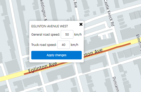
View and update truck speed limits on the Map
If there is a custom speed limit for trucks on a specific road segment, click the road segment on the map to view the general posted speed limit (left) and the truck-specific speed limit (right). To update either speed limit, select Update posted road speed from the list.
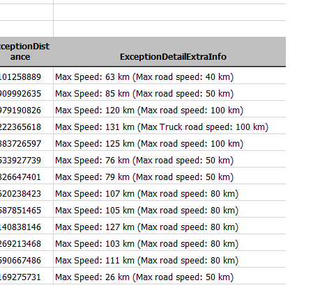
Exception reporting using truck speed limits
Speeding exception reports now uses truck-specific speed limits for vehicles in groups that have opted to use this. When exceptions are calculated against truck-specific speed limits, the application indicates the maximum truck speed limit for your convenience.
Maintenance Reminders
Maintenance & Reminders design and functionality refresh
Maintaining your fleet is now easier than ever with the redesigned Maintenance & Reminder feature in MyGeotab. We’ve added a new feature to bulk import previous maintenance records, along with the existing features to schedule preventive maintenance, receive reminders about upcoming and overdue maintenance and log completed maintenance. All of these features come with a new and improved, simple, easy-to-use UI and intuitive user journey. Currently these updates to Maintenance & Reminder features are only available in feature preview.
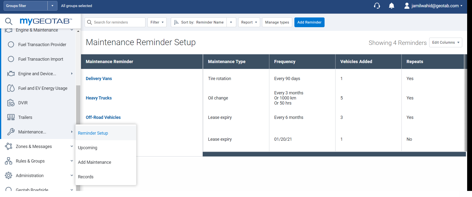
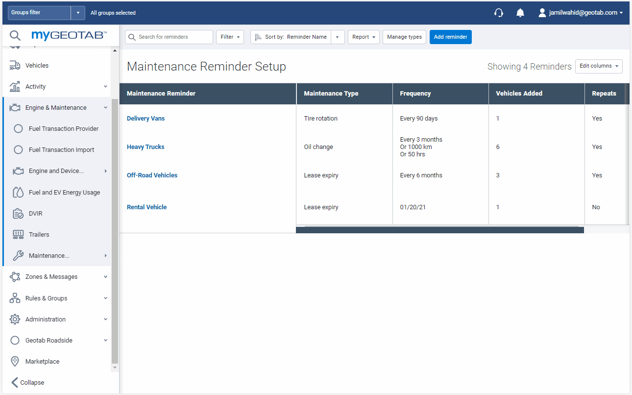
View all reminder rules
We’ve added a new Maintenance Reminder Setup page. The Maintenance Reminder Setup page makes it easy to view all scheduled maintenance reminders in a single place. For each maintenance reminder, you can also view the following details: maintenance type, repeat frequency and number of vehicles. To view a list of scheduled maintenance reminders, go to Engine & Maintenance > Maintenance > Reminder Setup from the main menu.
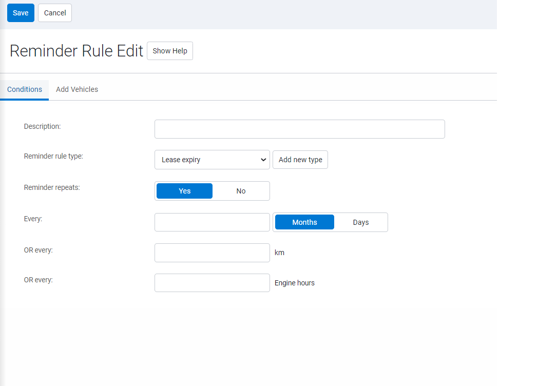
Add a maintenance reminder
Easily add reminders for maintenance by navigating to Engine & Maintenance > Maintenance > Reminder Setup> Add Reminder.
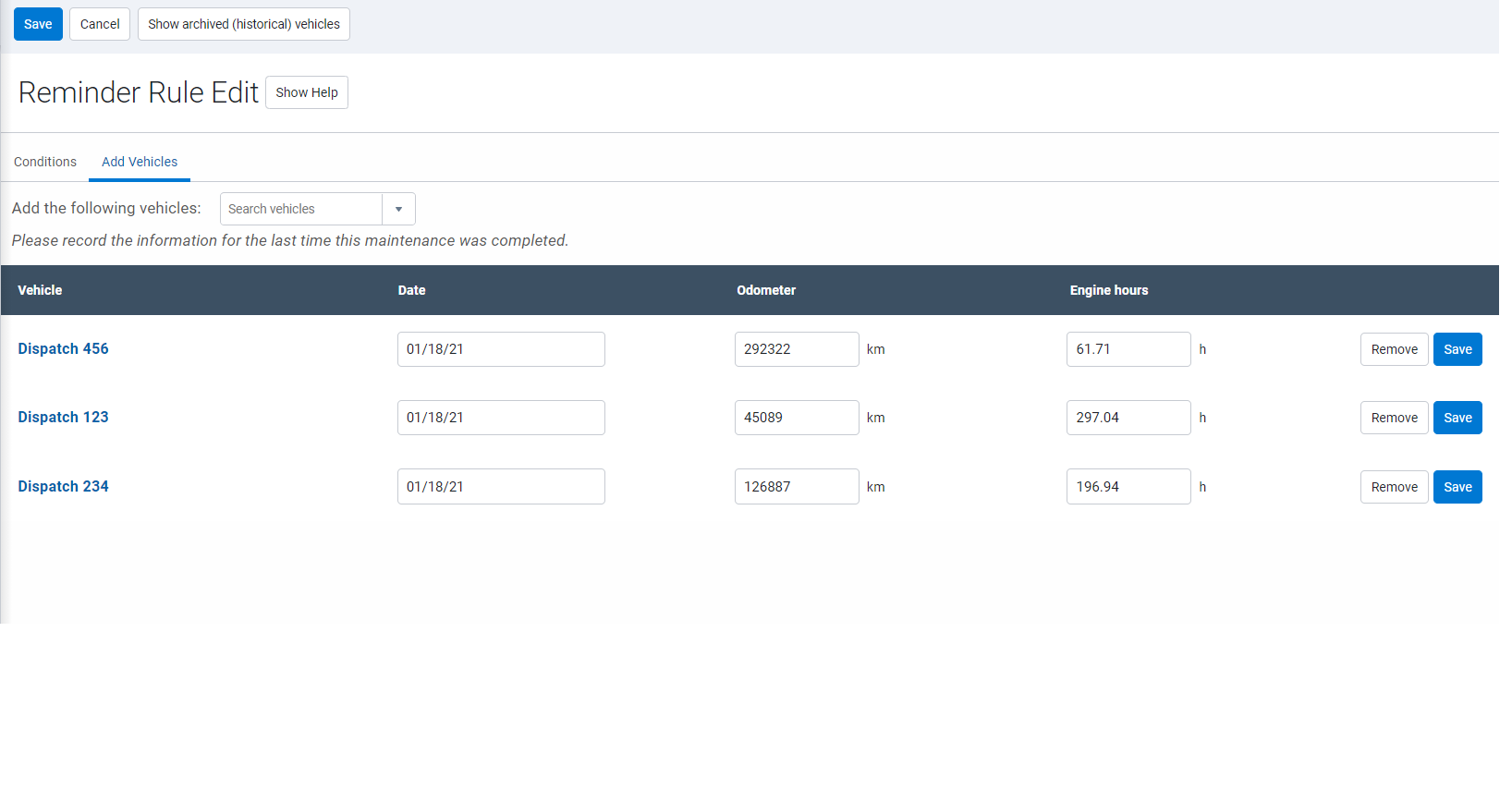
Users can set up the conditions to the reminder based on time or usage (odometer and engine hours). We also support non-repeating one off reminders. Appropriate vehicles for the reminder can easily be selected from the Add Vehicles tab.
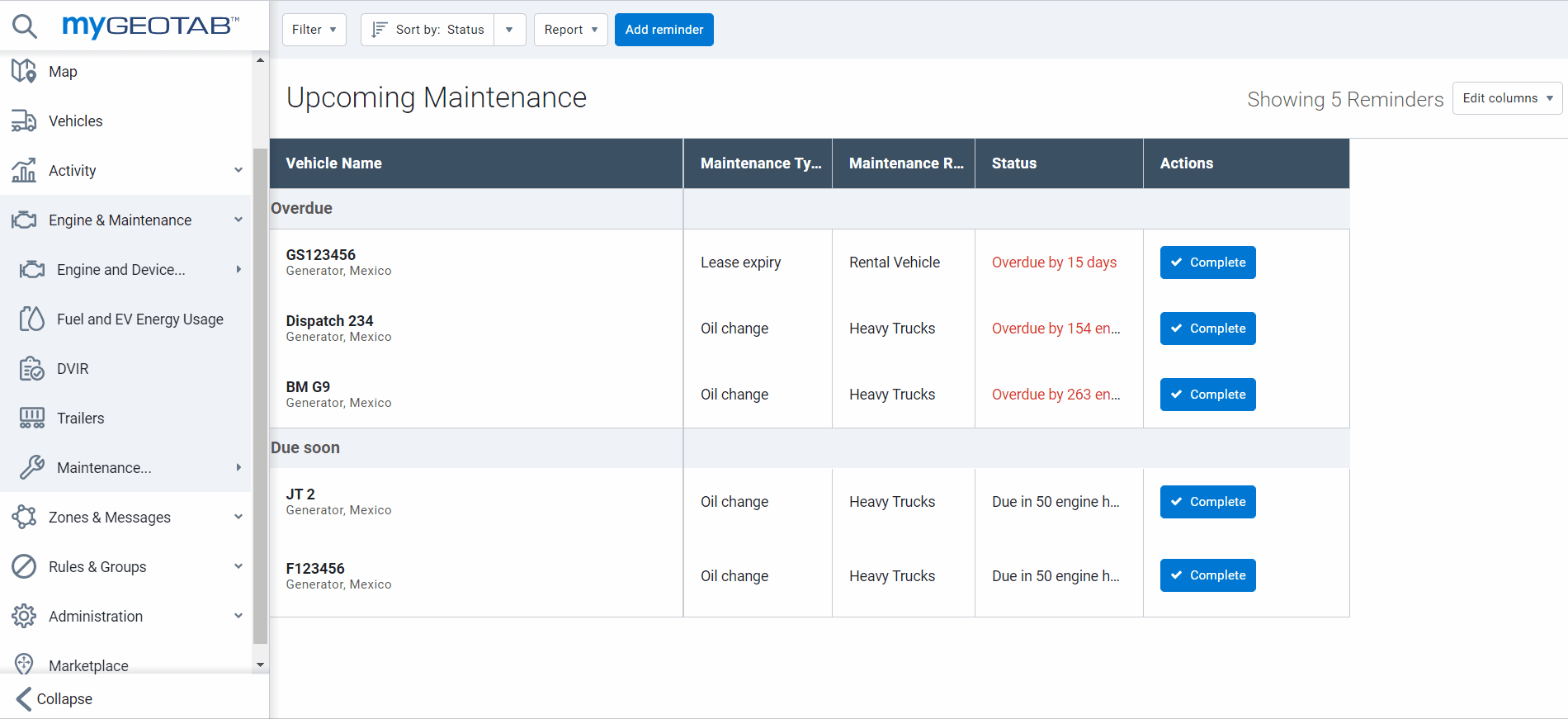
View upcoming maintenance work
Find everything you need to manage your maintenance schedule on our new and improved Upcoming Maintenance page! We've added select filter and sorting tools for vehicle, maintenance type, status and reminders to help you find what you need fast, while avoiding overdue maintenance events. Navigate to Engine & Maintenance > Maintenance > Upcoming to start planning today.
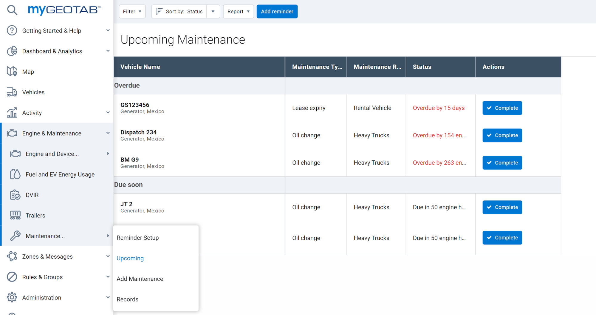
Log completed maintenance
We've made it easier to log completed maintenance work. Click the Complete button beside the maintenance record on the Upcoming Maintenance page, then add your details on the Edit page. Don’t forget to add your comments.
Quick-add maintenance records
Want to add a maintenance record but skip the reminder? Simply navigate to Engine & Maintenance > Maintenance > Add Maintenance. Select your vehicle, your maintenance type, a reminder rule, add your details – and you’re done.
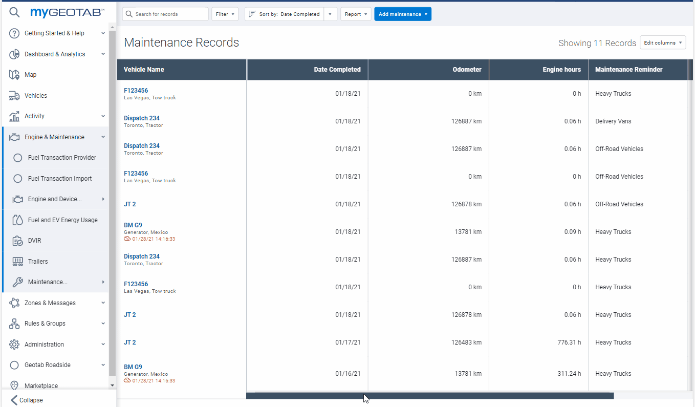
View completed maintenance records
Need to find maintenance records fast? Find them all in one compact and convenient page. For a closer look, use the Filter feature to see only the records you want.
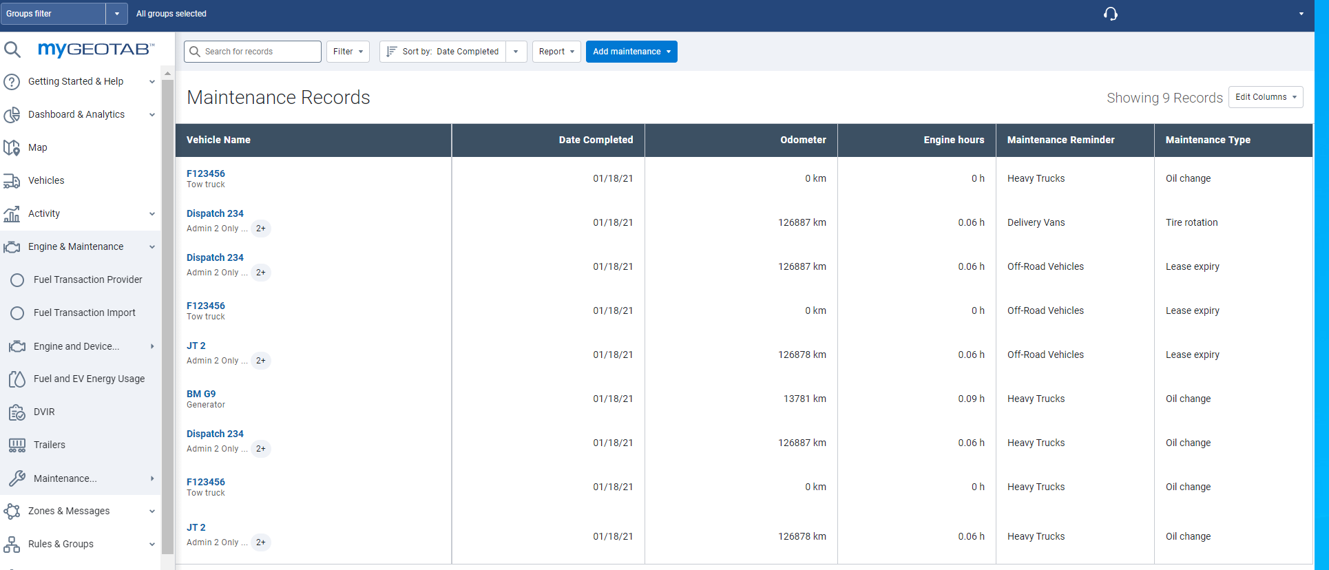
Build your maintenance history in one convenient location
You asked for it, and we built it. Users can now import all existing maintenance records into the Fleet Management Application. For a complete history of vehicle maintenance in one convenient location, simply download the Excel template, follow the instructions provided, and upload your records using the Bulk Import tool.
User
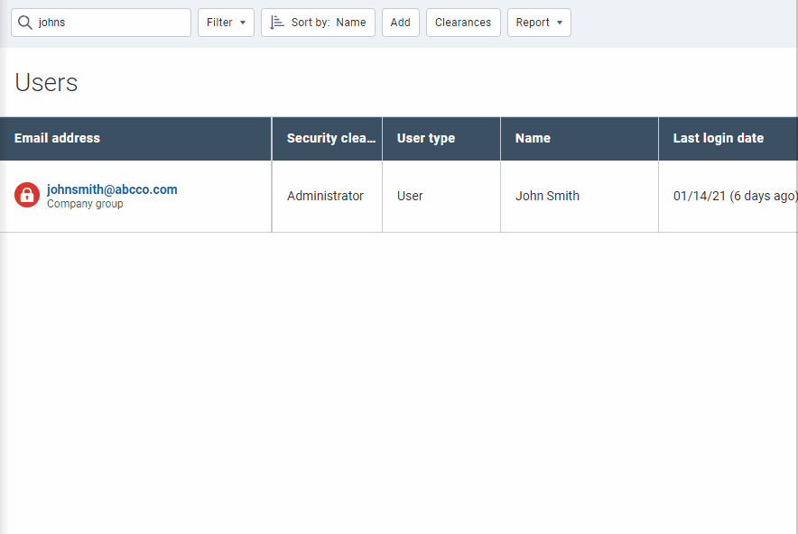
A new way to unlock user accounts
For Administrators answering the call from users who have exceeded their login attempts, and have locked themselves out of the application, simply visit the Users page, click the lock icon beside the user, then click the Unlock button.
General improvements
- Implemented bug fixes and resolved translation issues.
- For vehicles using solely the GPS odometer, we've updated the language on the Vehicle Edit page to display "(engine odometer last reported XX days ago - now using GPS)” instead of "(XX days ago - using GPS).
- SAML users can now edit certificates from the System Settings page.
- For better results, we've added new sorting capabilities on the live Map.
- Missing those familiar Diagnostic Trouble Codes (DTC)? The notification token “{Diagnostic code}” will now display in DTC format. This means that if an EVAP system leak (large leak) is detected, the {Diagnostic code} is generated as "P0455" instead of "1109".
- The Billing Tier name for Telematics Device version 9+ is now displayed in brackets next to data usage.
- A View Details option has been added showing Text Messages as Sent, Delivered and Read.
- For more access to support, the Support Contact page has been updated to display both Support and Reseller contact information.
- To better represent what users can do, we’ve updated the security identifier on the Security Clearances page from "Administer Work Holidays" to “Administer Work Hours and Work Holidays”.
- To better represent what users can do, we've updated the security identifier on the Security Clearances page from "Administer Work Hours" to "View Work Hours".
- An OBD Alert Status column has been added to the Watchdog Report.
Geotab SDK and Add-In updates
Community Integrators Hub
We’ve added a new group to Geotab Community. We call it the Integrator Hub. The Integrator Hub is a subscription-based group that functions as a centralized location for informational updates about Geotab’s open platform. We encourage integrators to join the group to receive the latest What’s New announcements, important notices, upcoming system changes, etc.
Map Add-In
Map Add-ins are now fully supported, and no longer in Feature Preview.
Storage API
Storage APIs are now fully supported, and no longer in Feature Preview.
General SDK updates
DeviceStatusInfo
When DeviceStatusInfo is calculated, the dates of GPS, status and fault records are compared and the latest recorded data point is used as the DateTime.
AddInData
Set method will now allow modifying value with no groups assigned.
CreateDatabase
Added a rate limit to the CreateDatabase method: 15/1m, 100/h, 800/1d.
Device
Added support for Untracked Vehicles.
DutyStatusLog
- Added the IsTransitioning property indicating whether an HOS log is in transition after the first driver accepts it.
- Added the IsHidden property.
DutyStatusLogType
- Added the properties CanadaCycleOne, CanadaCycleTwo, OperatingZoneCanadaSouthOf60, OperatingZoneCanadaNorthOf60, and OperatingZoneAmerica.
- Added INT_CoDriver.
DutyStatusViolationSearch
DutyStatusViolations can now be searched by user company or driver groups.
DVIRLog
Updated the documentation for Canada-specific fields on DVIRLogs (LoadHeight, LoadWidth, and Odometer) to better describe how they are populated.
FaultState
Added new columns in the data tab of Engine Fault Reports for better detection of engine fault states. This is mainly system data that helps the report function properly.
Get:DutyStatusLog
Fixed bug getting latest log for all users.
Get:StatusData
Users can now extrapolate the status date for diagnostics using the unit of measure "None" when "Get" is used with search (device, diagnostic, from and to date).
GetFeed:DeviceStatusInfo
Added GetFeed of DeviceStatusInfo.
Groups
Removed the PrivateUserGroups method.
MessageContentType
Added MimeContent MessageContentType.
MimeContent
Fixed documentation of maximum size.
RuleSearch
Fixed a bug getting zone stop rules.
SDK Runner
Fixed a rendering bug with UI JSON causing it to fail on an empty object.
sdk-addin-samples:proximity
- Removed ResultsLimit of 1000 for the Get<Device> request.
- Get<Device> request now accepts wildcard searches.
- Added a Run, Select All and Deselect All button.
- Updated warning messages if an input is missing or invalid when a user clicks Run.
- Updated minor UI aesthetics.
sdk-map-addin-samples
Added a new sample illustrating tooltip which displays the odometer, fuel level, and battery charge level (if applicable) of a vehicle.
SecurityIdentifier
- Added ViewDeviceShare, ViewDeviceShare.
- Added InstallRecord.
- Added ViewUserDeviceLink, ViewUserDeviceLink.
VersionInformation
Added the ServerId property, a unique identifier for a server/cluster.
Contributors:
Vik Sridhar, Sr. Product Manager, Jamil Wahid, Product Manager, Inshaal Badar, Sr. Content Specialist and Technical Writing Team
Subscribe to get industry tips and insights
The MyGeotab and Technical Writing Teams write about MyGeotab updates for Geotab.
Table of Contents
Subscribe to get industry tips and insights
Related posts

The plug-and-play rental fleet: Upgrade your technology without missing a single booking
April 27, 2026
5 minute read

The Evolution of Product Updates: Welcome to Your New Centralized Hub
December 15, 2025
2 minute read