Building global road safety with telematics
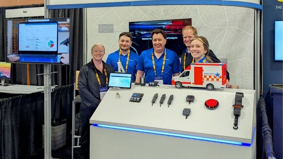
Geotab sponsored the NETS Latin America Satellite Conference on road safety in San Jose, Costa Rica.

Vice President, Connected Car and Platform Solutions
May 1, 2019
Updated: Dec 28, 2023

Road safety is a global area of concern, particularly for low-income countries which have three times the death rate of high-income countries. Though legislative improvements have been made in many countries, the global number of road traffic deaths each year is over 1 million and continues to increase, according to the World Health Organization’s 2018 Global Status Report on Road Safety. Road incidents have been identified as the leading cause of death for children and young adults ages 5-29.
The Network of Employers for Traffic Safety (NETS) has the objective of advancing road safety for all. Geotab sponsored their first Latin America Satellite Conference last month in San Jose, Costa Rica. Fleet managers, government officials, local road safety advocates and fleet industry leaders continued the conversation of improving vehicle and driver safety in the region. At the show, Geotab shared how telematics and big data and insights add value to global road safety initiatives.

Sherry Calkins, Geotab's AVP Strategic Partners said:
“Geotab has been a proud supporter and member of NETS for several years and this year was a significant milestone to have the first-ever NETS road safety conference in Latin America. This conference brought together industry thought leaders to discuss real-world solutions and road safety challenges. We are building a global road safety culture and awareness that goes beyond corporate fleet transportation.”
Joseph L. McKillips, Executive Director of NETS reflected on the conference proceedings:
“It is safe to say the inaugural NETS Latin America Satellite Conference was a tremendous success. The level of engagement and willingness to share road safety best practices was special to watch as attendees openly shared some of their most pressing road safety challenges (and solutions) throughout the entire event."
"Networking and collaboration with a variety of local government officials was also on display resulting in an impressive mix conversation and best practice exchange. Building upon this momentum in the future will remain a top priority of NETS as we continue to expand our presence and value to fellow members, sponsors and road safety advocates alike.”
See also: Why 5 star safety ratings matter
Big data making safety improvements
Regardless of background, affluence, geographical location, or otherwise, road safety and lack thereof has affected us all. At the conference, we shared insights on how accidents can be prevented by monitoring driver behaviour and providing feedback.
Fleets can increase driver safety through the usage of customizable rules and reports in MyGeotab based on real risk exposure. Managers can analyze trip history, set speed limits and monitor driving behavior such as seat belt use, engine abuse, harsh acceleration or harsh braking, and more.

Sample fleet safety report from Geotab.
Data captured through risk management reports can help reinforce company safety policies and create an even playing field within organizations, enforcing fair practices. Integrating a fleet safety solution with telematics such as the Driver Challenge software Add-In, which is a gamification solution, allows companies to qualify and compare each of their drivers against the fleet average and goals.

The Driver challenge gamification app integrates with Geotab.
Data and analytics can help communities identify risk areas and take measures to prevent accidents. As an example, see the heat maps below of hazardous driving areas in Bogota, Colombia.

Heat map of speeding zones in Bogota.
Real world conditions can be analyzed through big data, showing traffic density, dangerous intersections, hyper-local on-road weather, and more. Our near real-time and historical data allows for detailed data-driven decisions to be made, and innovative technology applications to be developed.

Harsh cornering zones.

Harsh braking zones.
More LatAm news:
Top 12 Most Popular Geotab Marketplace Solutions for LatAm
Fleet Safety and Sustainability in Latin America
Subscribe to get industry tips and insights

Vice President, Connected Car and Platform Solutions
Sherry Calkins has been involved in the global Fleet, Mobility and Automotive industry for over 20 years, working both nationally and globally.
Table of Contents
Subscribe to get industry tips and insights
Related posts

Creating a fleet safety culture that’s built to last: Lessons from Missouri DOT and NYC
July 7, 2025
8 minute read

The fleet safety incentive program checklist for driver engagement that lasts
June 19, 2025
2 minute read

Building a self-sustaining school bus driver safety program with Geotab Vitality
June 13, 2025
7 minute read

55+ Surprising distracted driving statistics and facts for 2025
May 30, 2025
8 minute read

Driving the Future of Public Safety: My Experience at Axon Week 2025
May 21, 2025
2 minute read
