Geocoding: why location is more than an address
Geocoding is the process of translating street addresses into geographic latitude and longitude coordinates for accuracy.

Chief Customer Officer at Geotab
Jan 5, 2023

Every business needs a well-developed map with zones of locations to provide an understanding of where people are, where they were, and the activities that took place. When it comes to something even as seemingly simple as address information, precision and accuracy are everything. Having the right information can result in saved time, money, and supports planning for future growth. Fleets achieve this accuracy with geocoding.
What Is Geocoding? Precision Matters in Business
Geocoding is the process of translating street addresses into geographic latitude and longitude coordinates. For example, the street address of the CN Tower is “301 Front Street W, Toronto, ON M5V 2T6” and the geocoded location is “43.642566,-79.387057”.
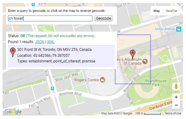
Geocoded geographic coordinates for the CN Tower in Toronto. Source: Google Maps API
In the world of fleet management, geocoding is important to the practice of creating zones. Every zone has a purpose. For example, a single customer may be grouped in more than one zone, e.g. a delivery zone for fleet drivers and also a sales zone for sales and marketing. Businesses may set restrictions on their zones so that only certain classes of vehicles are allowed to enter those areas.
MyGeotab offers three default zone types to get started: customer, home, and office. There is a lot of flexibility in that users can create and name their own additional custom zone types. In terms of adding zones through the Geotab Software Development Kit (SDK), our SDK documentation offers great explanations and some good examples (see these JavaScript Examples or .NET Examples). Find more information on setting up zones in this article on geofencing.
Whatever the zone, it starts with location. Because location is more than an address, it’s important to understand the different types of locations that map providers consider, how location data can be made more useful for businesses, and where location data is heading.
Three Business Use Cases for Geocoding
In general, there are three different address or geocode locations that businesses use for distinct purposes.
1. Street Address: Where Billing Happens
A street address is used for both invoicing and the general street curb location of a company. Few deliveries happen from the exact street address location because the street address is at the curb, and buildings are located farther from the curb. Thus, using street addresses for routing purposes doesn’t work for many businesses. Here’s why.
To create a zone that encompasses the building and parking lot inside, the zone must be drawn larger. However, this method doesn’t work when you have several customers near each other. The individual customer zones will end up overlapping each other. When vehicles park in an overlapping area of two zones, the stop will be reported to be in both zones, which can muddle job tracking and dispatch. To avoid this confusion, Geotab takes an additional step to ensure fleets can draw precise geofences by allowing you to draw zones on a map that precisely follow property or parking lot areas.
At Geotab, we perform what’s called reverse engineering a street address into a geocode. This means bulk importing street addresses and sending them electronically to our map provider, in which we pay a license fee to receive the specific latitude and longitude. However, there is a margin of error. That’s because map providers do not geocode every single street number — they generalize over a distance. Why does this matter? If you are exporting customer data from your billing or CRM system, you can expect a number of rejections. Street addresses must match perfectly with spelling, spaces, city, and state.
2. Delivery Location: Where the Action Happens
For many fleets, street address is more of a formality than a final destination. A “delivery location” is where vehicles park to serve a specific location. Loading docks or delivery departments are usually at the back of a building. Sometimes the location where a vehicle parks to serve a customer is closer to another street which is near or behind the actual street address.
Not having the accurate delivery location means that the truck may pull up in the wrong place and may even have to get out of the cab to ask for help and find the right place to park. In this competitive economy where customers expect rapid and just-in-time delivery, wasting time on parking impacts productivity and profitability.
If you’ve ever ordered an Uber ride, you may have experienced this type of address confusion. You’re waiting at the front of the hotel for your ride, while the Uber driver has gone around to the side or back of the building for the pick up.
What’s better for routing is the use of exact “pin” location. In some cases, this may mean routing a vehicle to a location other than the street address geocode, which are built organically. To create pin locations, you need to import the customer zones (using street address locations) and then layer on top the actual delivery location latitude/longitude geocode. The zone size can be small as it is more accurate (and helpful) to reflect the actual location where you want vehicles to travel.
3. Dead Center of Building: Where Location Data Is Moving
New map provider layers are looking at the calculated dead center of the building. While still in the beginning stages and not every building is mapped, this detailed approach to mapping takes a look at the shape of the building outline and calculates the dead center of the building. The theory is that this data can be licensed and would be even more accurate than the street address.
However, dead center location data causes the same problem as street addresses, in that you have to draw a very large zone since you would not know where within that area the driver is actually going to need to go.
Does Your Location Data Help or Create Confusion?
Ask yourself how much time dispatchers and drivers spend figuring out where exactly they need to be. Do they waste time parking to figure out where they should make the actual delivery? Are you losing visibility over drivers because they have to leave a pre-defined zone to make the delivery? Besides wasted time, is confusing location data putting employees in a potentially unsafe environment out in the field?
Make location data worthwhile for your business. Moving beyond street addresses will allow you to create detailed, accurate zones for better routing and improved productivity. Discover some helpful tools for fleet productivity on our website.
Related: Do You Have a Big Data Graveyard?
GeoCoding and a Look At Microsoft Bing Maps - Geotab
Subscribe to get industry tips and insights
Chief Customer Officer at Geotab
Colin Sutherland brings to Geotab over 25 years in senior sales and marketing leadership.
Table of Contents
Subscribe to get industry tips and insights
Related posts


Why field service routing decisions are costing you more than fuel (and how to fix it)
May 14, 2026
4 minute read

Cargo theft prevention has entered the AI era. Is your fleet keeping up?
May 11, 2026
4 minute read
How fuel transaction controls help fleets manage costs in a volatile market
April 28, 2026
3 minute read

The asset black hole: Why your equipment disappears the moment it leaves your facility
April 23, 2026
4 minute read