Revealed: the highest road in every U.S. state
Geotab study ranks America’s most breathtaking views
September 1, 2021
•1 minute read
Toronto, ON - November 27, 2018 - Geotab, a global leader in IoT and connected transportation, has launched a new study analyzing U.S. road data to identify the highest paved road in every state in America. The interactive piece, which also ranks the top ten most breathtaking views, can be accessed in full here.
By analyzing the U.S. Geological Survey’s National Elevation Dataset, Geotab was able to determine the highest road coordinates in each state. Aside from identifying the highest, reachable peaks, Geotab also leveraged the expertise of renowned outdoor photographer, Tony Bynum, to help determine the ranking of the ten most breathtaking views in America that can be accessed by hitting the open road.
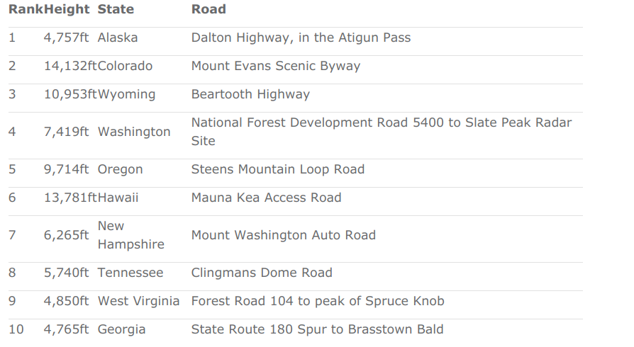
At 4,757 feet, the highest point of Alaska’s Dalton Highway (in the Atigun Pass on the Continental Divide) was identified as having the most stunning view in America. Taking second place is Colorado’s Mount Evans Scenic Byway. At 14,132 feet at its peak, it is the highest paved road in North America and one of the highest in the world.
“I’ve visited all of the roads on this list and there is simply nothing like Alaska for solitude and breadth of views,” says Tony Bynum, outdoor photographer and conservationist. “In general, western U.S. scenery is the ‘best’, with a tendency to offer better visibility – up to 100 miles on clear days. However, most of the higher elevations in the west are closed in winter, whereas the central and eastern roads are often available all year round.”
The full ranking of America’s 10 most breathtaking views is below:
“This piece serves as a useful reminder of the sheer beauty that can be seen across America’s world-leading road network,” said Maria Sotra, VP of Marketing at Geotab. “Thanks to the nation’s ever-growing infrastructure system, you no longer have to embark on a grueling hike or commit to climbing a mountain in order to take in an awe-inspiring view. Instead, breathtaking views can often be seen from behind the wheel of a car.”
Explore the full findings and view the stunning landscape photography here: https://www.geotab.com/americas-highest-roads/
About the data
U.S. Census TIGER/Line® Shapefiles were used to build a set of coordinates representing segments of every road in the United States, then the U.S. Geological Survey’s National Elevation Dataset was applied to establish the height of each segment. Google Maps and OpenStreetMap data was used to exclude roads that were not clearly accessible via an ordinary road vehicle. Roads were analyzed in October 2018. Main background image of Mount Evans supplied by Airphoto. All photo credits and licenses.
Media Contact
Nicole Riddle
Media Relations Manager
pr@geotab.com
About Geotab
Geotab is a global leader in connected operations, video telematics and AI-powered insights. Trusted by more than 100,000 customers — from small and mid-size fleets to Fortune 500 enterprises and public-sector organizations, including the U.S. federal government — Geotab connects approximately 6 million vehicles and assets and processes 100 billion data points daily. With ISO/IEC 27001:2022, SOC2, FIPS 140-3 and FedRAMP authorizations, Geotab's open platform and partner ecosystem unify safety, compliance and operations in a unified system. Our mission: a safer, more efficient and more sustainable world in motion. Learn more at www.geotab.com and follow us on LinkedIn or visit Geotab News and Views.
GEOTAB and GEOTAB MARKETPLACE are registered trademarks of Geotab Inc. in Canada, the United States and/or other countries.
Geotab in the News
Related News

Geotab and Predictive Coach Transform Fleet Safety with Real-Time Driver Coaching
August 20, 2025
2 minute read

Santa’s Sleigh Runs on Magic – But It’s Telematics That Keep It Efficient and Sustainable
December 18, 2024
2 minute read
Geotab’s 2025 Predictions: AI Powers Efficient, Safer Fleets
December 12, 2024
2 minute read
.jpg)
Empowering fleets through data: Geotab and Rivian partner to deliver integrated telematics solution
May 21, 2024
1 minute read